MyTopo
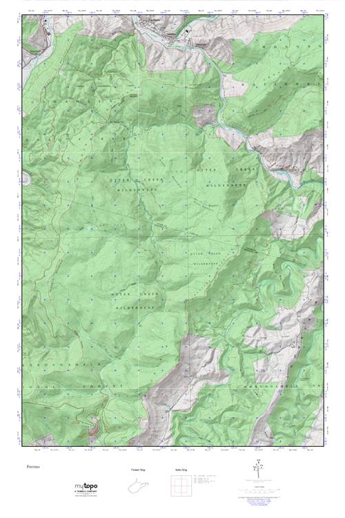
Otter Creek MyTopo Explorer Series Map
Couldn't load pickup availability
Topographic map of Otter Creek in the state of West Virginia. From the MyTopo Explorer Series.
This topo map features shaded relief and comes with UTM / MGRS and Latitude/Longitude grids.
For more than two decades, MyTopo has provided maps to the most adventurous among us.. those who love to explore our nation’s remote wilderness areas, climb our highest peaks, and trek across our vast public lands. This map is part of a curated collection of the most popular places for which MyTopo customers have designed maps. It is a “bucket list” of the most amazing places to hike, hunt, and explore.
This map contains the following named places: Bear Run,Bennet Rock Trail,Big Spring Run,Big Springs Gap,Big Springs Gap Trail,Black Fork District,Blackwater River,Brushy Creek,Camp Hollow,Cave Run,Coal Run,Condon Run,Coon Bone Island,Devils Gulch,Dry Fork,Elklick Run Spring,Ferron Experimental Forest,Fishing Trough Hollow,Fork Mountain,Green Mountain,Green Mountain Trail,Haddix Run,Hamrick School,Harper Run,Hendricks,Hendricks Post Office,Hickman Slide Hollow,Hog Knob,Hog Run,John B Hollow,Kent Lambert Spring,Kerns Cemetery,Krafts Ridge,Kuntzville,Laurel Run,Lester Falnagan Spring,McGowan Mountain,McNeely Cemetery,Moore Run,Moore Run Trail,Mountain Side Trail,Mylius School,Otter Creek,Otter Creek School,Otter Creek Trail,Otter Creek Wilderness,Otter Creek Wildlife Management Area,Panther Camp Ridge,Panther Camp Run,Possession Camp Run,Red Run,Red Run Station,Richford,Rosendorf,Shavers Lick Run,Shavers Mountain Trail,Slip Hollow,Spring Run,Sully,Three Spring Run,Town of Hendricks,Turkey Run,Turkey Run Trail,Two Spring Run,Wilson Hollow,Yellow Creek,Yellow Creek Trail