MyTopo
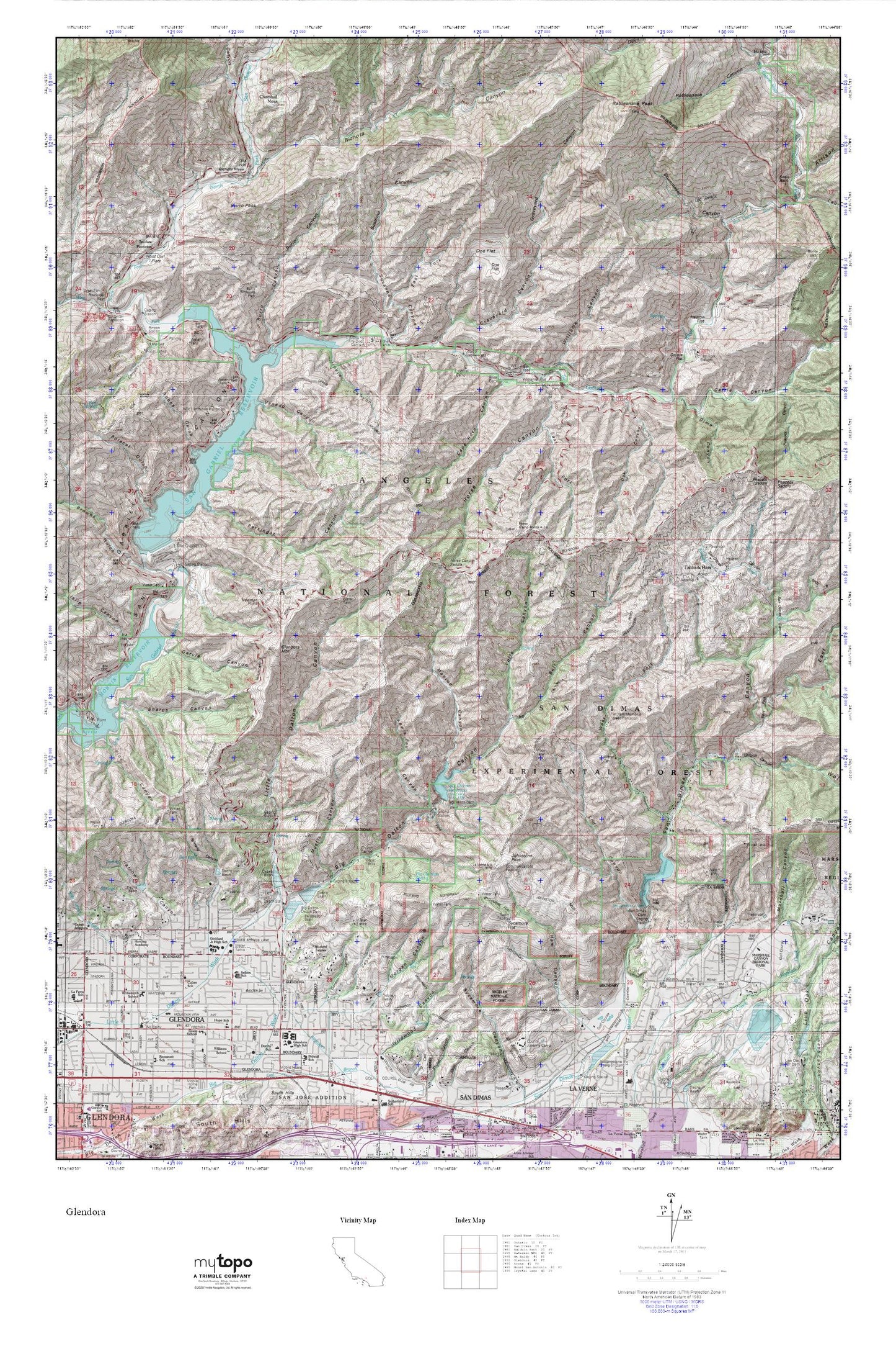
Glendora MyTopo Explorer Series Map
Couldn't load pickup availability
Topographic map of Glendora in the state of California. From the MyTopo Explorer Series.
This topo map features shaded relief and comes with UTM / MGRS and Latitude/Longitude grids.
For more than two decades, MyTopo has provided maps to the most adventurous among us.. those who love to explore our nation’s remote wilderness areas, climb our highest peaks, and trek across our vast public lands. This map is part of a curated collection of the most popular places for which MyTopo customers have designed maps. It is a “bucket list” of the most amazing places to hike, hunt, and explore.
This map contains the following named places: 91741,91750,Allison Gulch,Area 1 Work Center Forest Service Facility,Azusa Powerplant Conduit,Bell Canyon,Berry Flat,Bichota Canyon,Bichota Mesa,Big Cienega Spring,Big Dalton 32-000 Dam,Big Dalton Canyon,Big Dalton Debris Dam,Big Dalton Reservoir,Browns Gulch,Burro Canyon,Burro Peak,Burro Shooting Park,Camp Bonita,Camp Oak Grove,Cape Horn Canyon,Carlin Military Academy,Cattle Canyon,Chamisal Mesa,City of Glendora,City of Glendora Fire Station 151,Cornerstone Bible Church,Cotton Tail Plantation,Coyote Flat,Cullen Elementary School,Dalton Forest Service Facility,Dalton Station,Davis Mine,Detention Camp,Dime Canyon,Doe Flat,East Fork Horse Canyon,East Fork San Dimas Canyon,East Fork Station,East Fork Susanna Canyon,Eldoradoville Campground,Englewild Canyon,Fern Springs,Finkbiner Park,First Christian Church,Flintham Memorial Forest Plantation,Follows Camp,Garcia Canyon,George Manooshian Park,Glendora,Glendora Alliance Church,Glendora City Hall,Glendora City Police Department,Glendora High School,Glendora Mountain,Glendora Public Library,Glendora Ranger Station,Goddard Middle School,Gordon Canyon,Grace Episcopal Church,Grace School,Graveyard Canyon,Ham Canyon,Harding Academy,Harrow Canyon,Heaton Flat,Hoot Owl Flats,Hope Lutheran Church,Hope Lutheran School,Horse Canyon,Horse Canyon Saddle,Hudson Bay Camp,Hummingbird Creek,Islip Canyon,Johnstone Peak,Keril Canyon,Laurel Gulch,Lewis Paul Canyon,Little Dalton Canyon,Little Dalton Debris Dam,Little Dalton Picnic Area,Lodi Canyon,Loraine Avenue Baptist Church,Lost Canyon,Lowell Brandt Park,Marshall Canyon,Marshall Canyon Golf Course,Mills Park,Minero Canyon,Monroe Canyon,Morgan Canyon,Morris Reservoir,Mount Baldy District Ranger Office,Mull Canyon,Mystic Canyon,Newman Point,North Fork San Gabriel River,Oak Canyon,Oaks Picnic Area,Ole Hammer Park,Peacock Canyon,Peacock Saddle,Persinger Canyon,Pigeon Target Shooting Area,Pine Canyon,Polecat Gulch,Rattlesnake Peak,Rincon Canyon,Robbs Gulch,San Dimas 32-010 Dam,San Dimas Canyon,San Dimas Canyon Golf Course,San Dimas Experimental Forest,San Dimas Reservoir,San Dimas Station,San Gabriel Dam,San Gabriel Guard Station,San Gabriel Reservoir,Sellers Elementary School,Shady Oaks Camp,Sharps Canyon,Shoemaker Canyon,Sierra La Verne Golf Course,Susanna Canyon,Swan Rock,Sycamore Flat,Tanbark Creek,Tanbark Flats,Tecolate Plantation,United Methodist Church of Glendora,Venedo Canyon,Volfe Canyon,West Fork Roadside Rest,West Fork San Dimas Canyon,West Fork San Gabriel River,Whitcomb Continuation High School,Wild Honeybee Plantation,Williams Camp,Williams Canyon,Williams Flat,Willow Springs Park,Wolfskill Canyon,Wolfskill Falls