MyTopo
Ipswich MyTopo Explorer Series Map
Couldn't load pickup availability
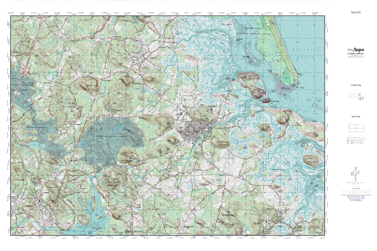
Topographic map of Ipswich in the state of Massachusetts. From the MyTopo Explorer Series.
This topo map features shaded relief and comes with UTM / MGRS and Latitude/Longitude grids.
For more than two decades, MyTopo has provided maps to the most adventurous among us.. those who love to explore our nation’s remote wilderness areas, climb our highest peaks, and trek across our vast public lands. This map is part of a curated collection of the most popular places for which MyTopo customers have designed maps. It is a “bucket list” of the most amazing places to hike, hunt, and explore.
This map contains the following named places: 01938,01969,01983,Appleton Farms,Aqawam,Averills Island,B W Palmer State Park,Bagwell Island,Bare Hill,Bartholomew Hill,Bear Hill,Bentley Heliport,Bialek Park,Black Brook,Blueberry Hill,Broad Creek,Bull Brook,Bull Brook Reservoir,Bull Brook Reservoir Dam,Burley School,Bush Hill,Cable Memorial Hospital,Candlewood Golf Club,Cawles Memorial Cemetery,Central School,Choate Bridge,Clark Pond,Cornerstones School,Cross Banks,Dow Brook,Dow Brook Reservoir,Dow Brook Reservoir Dam,Doyon Memorial School Library,Eagle Hill,Eagle Hill River,Eagle Hill River Marshes,Eagle Island,Egypt River,Essex County,Essex School,Fifteen Tree Hill,First Church in Ipswich,First Congregational Church,Fourmile Pond,Fox Creek,Free Public Library,Grape Island,Grape Island Creek,Gravelly Brook,Great Hill,Great Neck,Hall-Haskell House,Hamilton,Hawk Meadow,Heartbreak Hill,Highland Cemetery,Hood Pond,Hood Pond Dam,Howlett Brook,Hunsley Hills,Ipswich,Ipswich Bay Yacht Club,Ipswich Bluff,Ipswich Census Designated Place,Ipswich Fire Department Station 1 Headquarters,Ipswich Fire Department Station 2,Ipswich High School,Ipswich Historical Society Building,Ipswich Junior High School,Ipswich Middle-High School Media Center,Ipswich Mills Dam,Ipswich Police Department,Ipswich Post Office,Ipswich Public Library,Ipswich River,Ipswich River Dam,Ipswich River Marshes,Ipswich River Reservoir,Ipswich Shopping Center,Ipswich Station,Ipswich Town Hall,Ipswich Visitors Center,Jewett Hill,John Heard House,Kent Corner,Kimball Brook,Labor in Vain Creek,Laws Creek,Leightons Corner,Linebrook,Linebrook School,Little Neck,Little Turners Hill,Locust Grove Cemetery,Long Causeway Brook,Long Hill,Lower Millpond,Lower Millpond Dam,Maryknoll Sisters Novitiate,Metcalf Creek,Middle Ground,Mile Brook,Mile Brook Dam,Mile Brook Reservoir,Miles River,Moon Hill,Muddy Brook,Muddy Run,Nancys Corner,Neck Creek,New Meadows Golf Club,North Ridge,Old North Burying Ground,Old South Cemetery,Our Lady of LaSalette Seminary,Paine Creek,Paul F Doyon Memorial School,Pigeon Hill,Pine Creek,Pine Grove Cemetery,Pine Grove School,Pinefield,Pingree School,Pingree School Library,Pintail Pond,Plover Hill,Proctor Elementary School,Prospect Hill,Pye Brook,Rantoul Pond,Rantoul Pond Dam,Rider Heliport,Rockery Pond,Roger Island,Roger Island River,Roger Island River Marshes,Rogers School,Rooty Plain,Rowley,Rowley Burial Ground,Rowley Census Designated Place,Rowley Fire Department,Rowley Post Office,Rowley Station,Rowley Town Police Department,Russell Orchards,Sacred Heart Juniorate,Sandy Point,Scott Hill,Shatswell School,Sisters of the Notre Dame de Namur,Six Goose Creek,Smith Hill,Snow Airport,Stacy Creek,Steward Elementary School,Third Creek,Tilton Hill,Timber Hill,Topsfield,Topsfield Census Designated Place,Topsfield Fire Department,Topsfield Post Office,Topsfield Station,Topsfield Town Library,Town Hill,Town of Ipswich,Town of Rowley,Town of Topsfield,Treadwell Island,Treadwell Island Creek,Turkey Hill,Turner Hill,Upper Millpond,Upper Millpond Dam,Vineyard Hill,Whites Hill,Willow Hill,Willowdale State Forest,Wilson Pond,Winthrop Elementary School