MyTopo
Snowden MyTopo Explorer Series Map
Couldn't load pickup availability
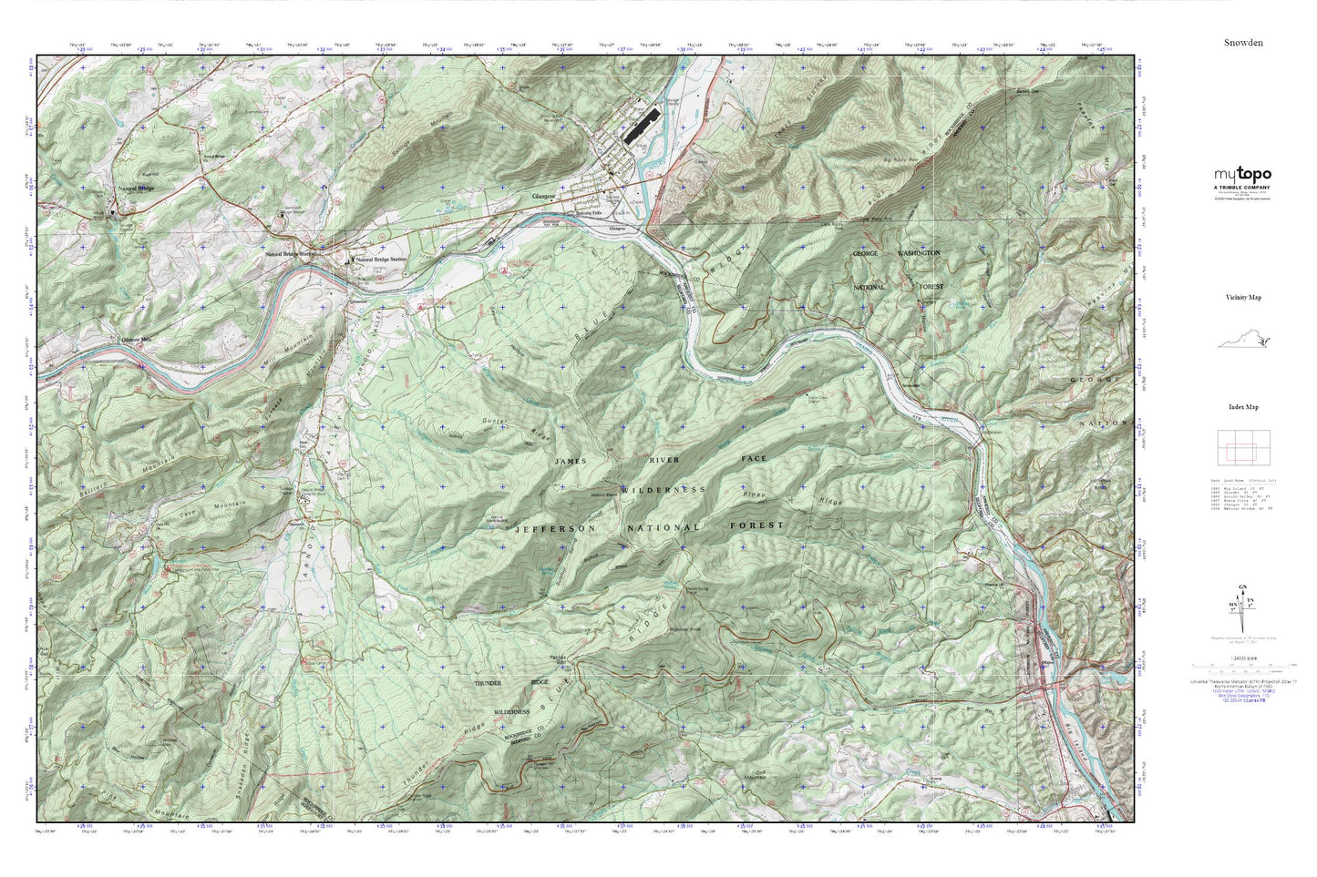
Topographic map of Snowden in the state of Virginia. From the MyTopo Explorer Series.
This topo map features shaded relief and comes with UTM / MGRS and Latitude/Longitude grids.
For more than two decades, MyTopo has provided maps to the most adventurous among us.. those who love to explore our nation’s remote wilderness areas, climb our highest peaks, and trek across our vast public lands. This map is part of a curated collection of the most popular places for which MyTopo customers have designed maps. It is a “bucket list” of the most amazing places to hike, hunt, and explore.
This map contains the following named places: 24579,Appomattox County Sheriffs Office,Arnold Valley,B G Locher Bridge,Back Run,Balcony Falls,Balcony Falls Dam,Balcony Falls Trail,Bear Hollow,Belfast Creek,Belfast Trail,Bellamy Creek,Big Cove Branch,Big Hellgate Creek,Big Rocky Row,Billys Branch,Black Bridge Airport,Brookville-Timberlake Fire Department,Buck Hill,Camp Powhatan,Campbell County Rescue Squad,Cashaw Creek,Cave Mountain,Cave Mountain Church,Cave Mountain Dam,Cave Mountain Lake,Cave Mountain Recreation Area,Cedar Creek,Crawford Creek,Cushaw Dam,Cushaw Reservoir,Devils Marbleyard,Drummond Hill,East Fork Elk Creek,Elk Creek,Faith Church,Falling Rock Creek,Furnace Mountain,Gilmore Mills,Glasgow,Glasgow Baptist Church,Glasgow Cemetery,Glasgow Elementary School,Glasgow Police Department,Glasgow Post Office,Glasgow Presbyterian Church,Glasgow Rescue Squad Rescue 3,Glasgow Volunteer Fire Department,Glenwood Church,Glenwood Furnace,Glenwood Ranger Station,Greenlee,Greenlees Ferry,Gunter Ridge,Gunter Ridge Trail,Hickory Stand,Highcock Knob,Hoop Pole Gap,Hopper Creek,Hopper Creek Group Camp,Hunting Spring,James River Face Wilderness,James River Valley Overlook,Johns Hollow,Johns Hollow Shelter,Little Hellgate Creek,Little Rocky Row,Locher Tract Picnic Area,Marble Spring,Marble Spring Shelter,Matts Creek,Matts Creek Shelter,Maury River,Mill Mountain,Natural Bridge,Natural Bridge Camp for Boys,Natural Bridge Church,Natural Bridge District,Natural Bridge Elementary School,Natural Bridge Post Office,Natural Bridge Station,Natural Bridge Station Post Office,Oppossum Hollow,Petites Gap,Piney Ridge,Piney Ridge Trail,Rocky Row Run,Rocky Row Trail,Salling Family Cemetery,Sawmill Hollow,Sharon Cemetery,Sheppe Pond,Skillern Mountain,Smith Tract Campground,Snow Creek,Snow Creek Recreation Area,Snowden,Sulphur Ridge Trail,Sulphur Spring,Sulphur Spring Hollow,Sulphur Spring Trail,Terrapin Mountain Overlook,Thunder Ridge Wilderness,Tolley Cemetery,Town of Glasgow,Wildcat Mountain,Wildcat Trail