MyTopo
Pisgah Forest MyTopo Explorer Series Map
Couldn't load pickup availability
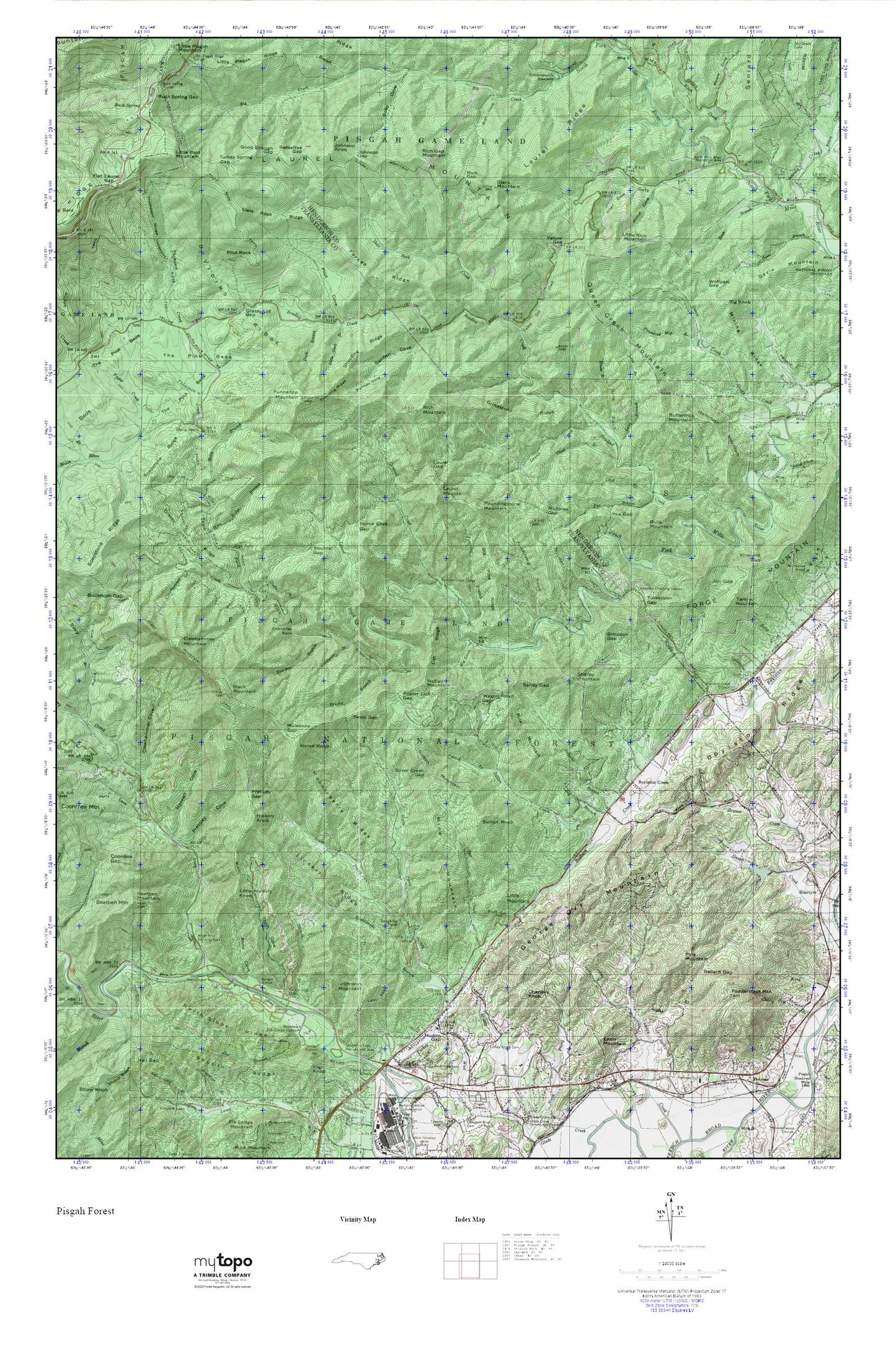
Topographic map of Pisgah Forest in the state of North Carolina. From the MyTopo Explorer Series.
This topo map features shaded relief and comes with UTM / MGRS and Latitude/Longitude grids.
For more than two decades, MyTopo has provided maps to the most adventurous among us.. those who love to explore our nation’s remote wilderness areas, climb our highest peaks, and trek across our vast public lands. This map is part of a curated collection of the most popular places for which MyTopo customers have designed maps. It is a “bucket list” of the most amazing places to hike, hunt, and explore.
This map contains the following named places: 28742,28768,Allen Cove,Andy Cove,Avery Creek,Ballard Gap,Bearpen Branch,Bearpen Mountain,Bee Branch,Big Cove,Big Creek,Big Knob,Big Pine Ridge,Billy Branch,Black Mountain,Black Mountain Trail,Blacksnake Branch,Blythe Branch,Boylston Baptist Church Graveyard,Boylston Creek,Boylston Creek Church,Boylston Ridge,Bradley Creek,Brushy Branch,Buck Mountain,Buck Spring,Buck Spring Gap,Buck Springs Lodge,Buck Springs Tunnel,Buckhorn Gap,Buckhorn Shelter,Buttermilk Mountain,Cantrell Creek,Cantrell Creek Lodge,Case Branch,Cat Ridge,Charleys Knob,Clawhammer Cove,Clawhammer Creek,Clawhammer Mountain,Coontree Gap,Copperas Rock,Darb Branch,Davidson River Recreational Area,Davie Mountain,Deep Gap,Dividing Ridge,Dog Creek,English Chapel,Enon Mountain,Flat Laurel Gap,Fodderstack Mountain,Forked Ridge,Funneltop Mountain,George Orr Mountain,Glady Branch,Goldmine Branch,Good Enough Gap,Grassy Lot Gap,Grassy Ridge,Grindstone Ridge,Hammett Branch,Hammett Mountain,Hawkins Lake,Hendersonville Reservoir,Hickory Knob,High Falls,Horse Cove Gap,Horse Knob,House Branch,Huckleberry Ridge,Hudlin Gap,Jim Gap,Johnson Gap,Johnson Knob,Johnson Mountain,Jumping Branch,Lake Tahoe,Laughing Falls,Laural Lake Dam,Laurel Brook,Laurel Creek,Laurel Gap,Laurel Lake Estates,Laurel Mountain,Laurel Mountain Trail,Laurel Ridge,Lindsay Ridge,Little Bald Mountain,Little Darb Branch,Little Hickory Knob,Little Mountain,Little Rich Mountain,Long Branch,Maxwell Cove,McCall Mountain,Mince Cove,Mine Mountain,Mine Mountain Estates,Mining Ridge,Moore Cove,Mother Earth Lower Dam,Mother Earth Upper,Mother Earth Upper Dam,Mount Pisgah Recreation Site,Muleshoe Gap,Mullinax Gap,Mullinax Trail,Nellie Cove,North Mills River Recreation Area,North Prong Turkey Creek,North Slope Ridge,North Transylvania Fire and Rescue Station 13,Oak Woods,Osborne Branch,Otter Hole,Pea Branch,Pea Gap,Perry Cove,Pierce Lake,Pilot Cove,Pilot Rock,Pilot Rock Trail,Pine Mountain,Pisgah Ranger Station,Polecat Branch,Poplar Creek,Poplar Lick Gap,Pounding Mill Branch,Poundingmill Branch,Poundingstone Mountain,Pressley Cove,Pressley Gap,Queen Creek Mountain,Rich Cove,Rich Gap,Rich Gap Mountain,Rich Mountain,Rocky Fork,Rush Branch,Sam Branch,Sandy Gap,Sassafras Gap,Schenck Job Corps Center,Seniard Creek,Sharpy Mountain,Shooting Ridge,Shut-in Branch,Silver Creek,Silver Creek Gap,Simpson Gap,Slate Rock Creek,Slate Rock Ridge,Soapstone Ridge,South Prong Turkey Creek,Squirrel Gap,Starens Branch,Stuart Cemetery,Sunfish Cove,Sutton Creek,Sutton Knob,Sutton Mountain,Sweetwater Branch,Tarkiln Mountain,Thad Branch,Thompson Creek,Thompson Ridge,Thompson Ridge Trail,Thrift Cove,Township of Boyd,Turkey Pen Gap,Turkey Spring Gap,Turkeypen Checking Station,Turkeypen Gap,Vineyard Gap,Wagon Road Gap,Wash Creek,West Ridge Branch,White Pine Camping Area,Wolf Ford,Wolfpen Gap,Woody Branch,Yellow Gap,Yellow Gap Creek