MyTopo
Chesterfield MyTopo Explorer Series Map
Couldn't load pickup availability
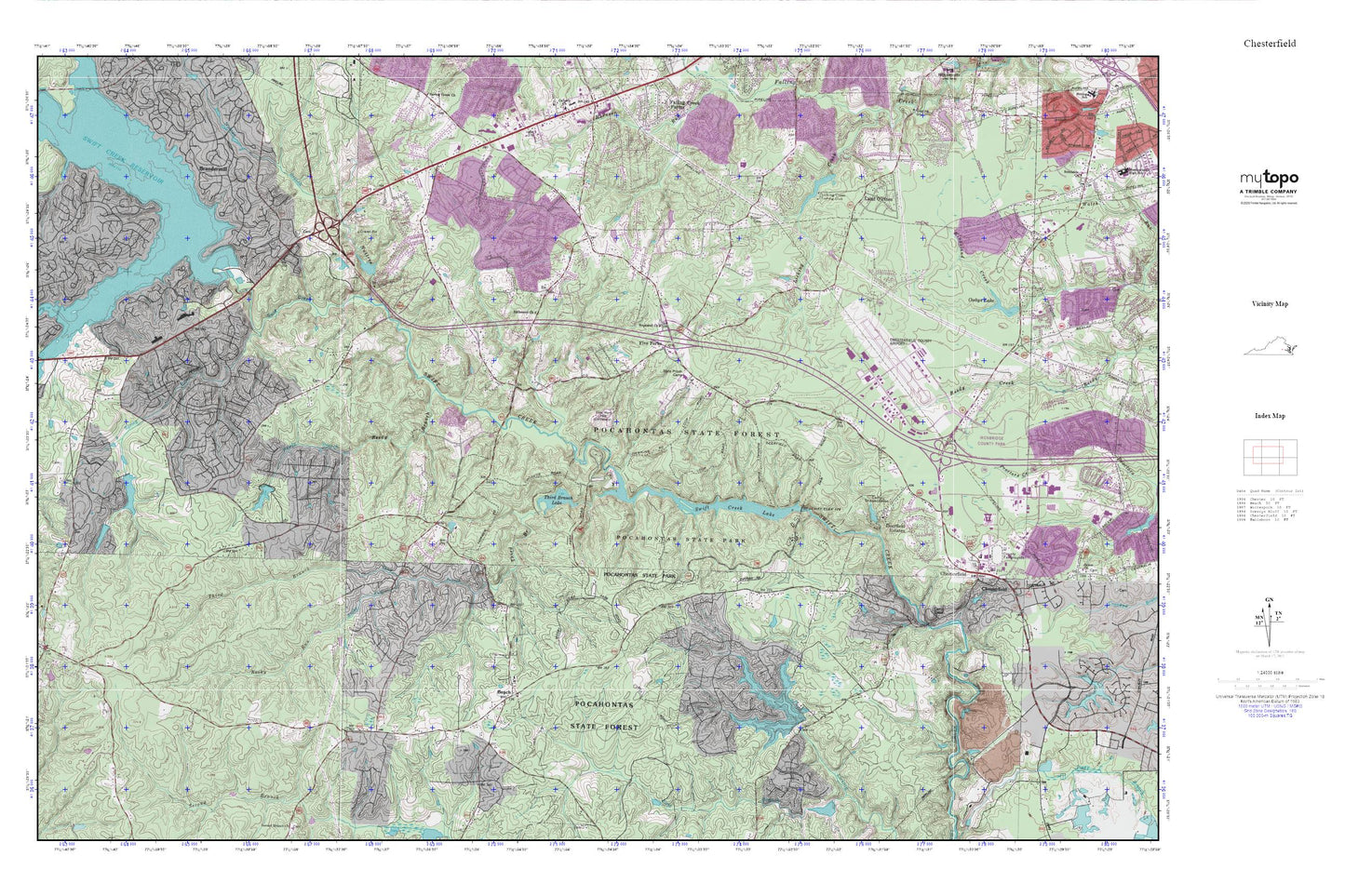
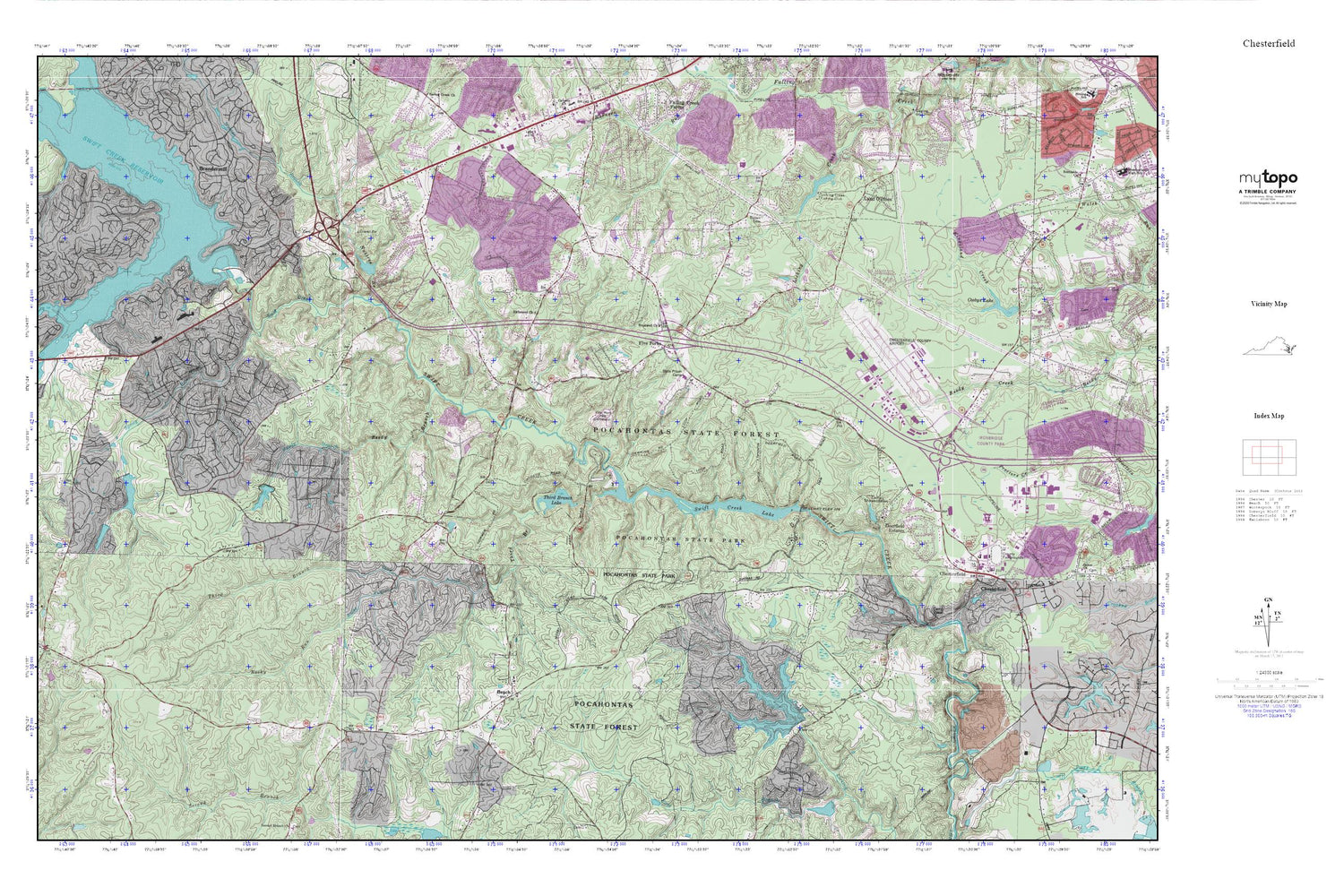
Topographic map of Chesterfield in the state of Virginia. From the MyTopo Explorer Series.
This topo map features shaded relief and comes with UTM / MGRS and Latitude/Longitude grids.
For more than two decades, MyTopo has provided maps to the most adventurous among us.. those who love to explore our nation’s remote wilderness areas, climb our highest peaks, and trek across our vast public lands. This map is part of a curated collection of the most popular places for which MyTopo customers have designed maps. It is a “bucket list” of the most amazing places to hike, hunt, and explore.
This map contains the following named places: 23112,23832,Airport Station Number 15,Alberta Smith Elementary School,Bailey Bridge Middle School,Beach,Beaver Dam,Bethia Church,Bethia United Methodist Church Cemetery,Birkdale Golf and Country Club,Brandermill,Brandermill Census Designated Place,Brandermill Post Office,Brown Grove Baptist Church Cemetery,Brown Grove Church,Camp Baker,Camp Shawondasee,Central Virginia Correctional Unit 13,Chesterfield,Chesterfield County,Chesterfield County Courthouse,Chesterfield County Fire / Emergency Medical Services Department - Administration,Chesterfield County Jail,Chesterfield County Museum,Chesterfield County Police Department Forensic,Chesterfield County Police Department Headquarters,Chesterfield County Police Department Vice,Chesterfield County Police Training Academy,Chesterfield County Public Library,Chesterfield County Sheriff's Office,Chesterfield Court House,Chesterfield Court House Census Designated Place,Chesterfield Detention Center,Chesterfield Fire and Emergency Medical Services Station 15 Airport,Chesterfield Fire and Emergency Medical Services Station 19 Winterpock,Chesterfield Fire and Emergency Medical Services Station 7 Clover Hill,Chesterfield Historical Society Museum,Chesterfield Industrial Park,Chesterfield Post Office,Chesterfield Women's Diverstion Center,Clover Hill Elementary School,Clover Hill High School,Clover Hill Station Number 7,Cosby Dam,Cosbys Lake,Crenshaw Elementary School,Dale District,Dale Memorial Park,Dale Quarry,Deerfield Estates,Dry Creek,Fendley,Five Forks,Fuqua Cemetery,Genito Estates,Genito Post Office,Good Hope School,Good News Free Will Baptist Church,Heritage Christian Academy,Hopewell Church,Hopewell Methodist Church Cemetery,Jacobs Road Elementary School,Jefferson Volunteer Fire Department,Kings Forest,Land O'Pines,Licking Creek Fishing Club,Licking Creek Fishing Club Dam,Licking Creek Fishing Club Lake,Manchester High School,Manchester Volunteer Rescue Squad Station 2,Midlothian Quarry,Nash Road Lake,Nash Road Lake Dam,Nuttree,Nuttree Branch,O B Gates Elementary School,Oak Forest Baptist Church,Old Tomahawk Cemetery,Perdue,Pocahontas Acres,Pocahontas State Forest,Pocahontas State Park,Pocahontas State Park Museum,Pre-Release Activities Center,Qualla Farms,Reedy Branch,Richmond Church,Richmond Executive-Chesterfield County Airport,Robinwood,Rock Castle Business Park,Rocky Run,Rolling Hills,Shoosmith Sanitary Landfill,SkysStat 1 Base 6,Southern Area Landfill,Spring Run,Spring Run Elementary School,Summit,Swift Creek Baptist Church,Swift Creek Dam,Swift Creek Farms,Swift Creek Lake,Swift Creek Reservoir Dam,Third Branch,Third Branch Lake,Tomahawk Church,Virginia State Police MedFlight I,West Branch Dry Creek,Winterpock Station Number 19,Woodlake,Woodlake Census Designated Place