MyTopo
Tray Mountain MyTopo Explorer Series Map
Couldn't load pickup availability
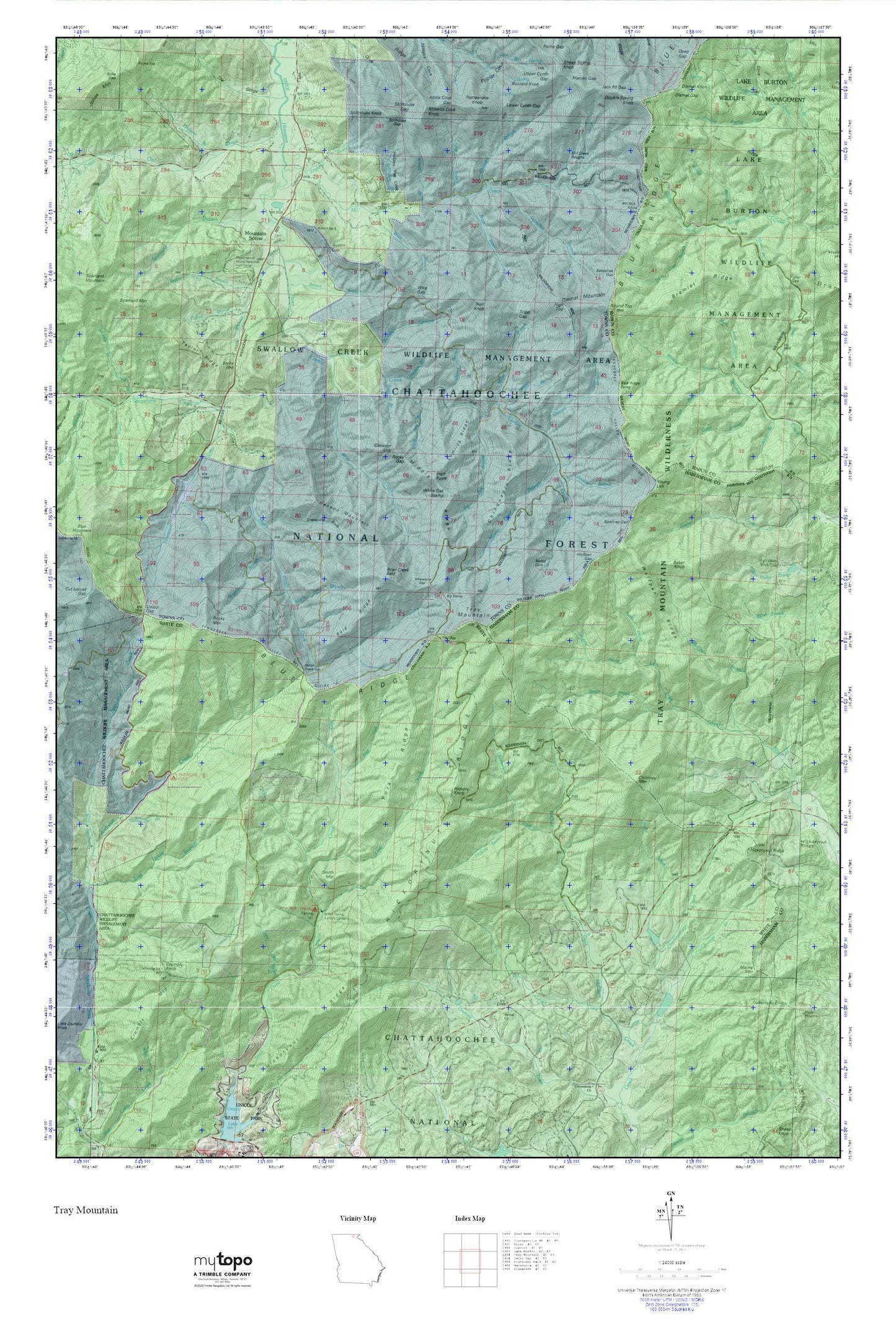
Topographic map of Tray Mountain in the state of Georgia. From the MyTopo Explorer Series.
This topo map features shaded relief and comes with UTM / MGRS and Latitude/Longitude grids.
For more than two decades, MyTopo has provided maps to the most adventurous among us.. those who love to explore our nation’s remote wilderness areas, climb our highest peaks, and trek across our vast public lands. This map is part of a curated collection of the most popular places for which MyTopo customers have designed maps. It is a “bucket list” of the most amazing places to hike, hunt, and explore.
This map contains the following named places: Addis Cove Gap,Addis Gap,Alice Branch,Andrews Cove Campground,Andrews Creek,Anna Ruby Campground,Anna Ruby Falls,Anna Ruby Falls Scenic Area,Austin Gap,Baker Knob,Bald Ridge,Beegum Branch,Bethel Cemetery,Bethel Church,Betty Branch,Big Net Branch,Big Stamp,Blue Ridge Swag,Bramlet Ridge,Brier Creek,Brier Creek Bald,Brown Branch,Buzzard Branch,Buzzard Knob,Carol Branch,Carroll Ridge,Chastain Creek,Chickamauga Branch,Chimney Mountain,Chinquapin Branch,Chinquapin Ridge,Corbin Creek,Craig Creek,Crowder Lick,Crumbly Knob,Crumbly Mountain,Department of Natural Resources Work Center,Devils Den Branch,Dismal Gap,Dismal Knob,Dismal Mountain,Double Branch,Double Spring Branch,Double Spring Knob,East Fork Smith Creek,England Branch,Fuller Gap,Grapevine Cove,Gurley Branch,Hanson Mountain,Hickory Branch,Hickory Flat Cove,Hickory Knob,Hickorynut Ridge,High Point,High Shoals Creek,High Shoals Falls Scenic Area,High Top,High Valley Boys Club,Hogpen Branch,Indian Grave Gap,Jack Pit Gap,Jake Branch,Kendall Branch,Little Net Branch,Lolly Cove,Lost House Branch,Lower Cynth Gap,Lumlick Ridge,Macedonia Division,Macks Mountain,Mandy Branch,Maple Spring Branch,Mary Anne Branch,McClure Creek,Middle Prong Left Fork Soquee River,Middle Ridge,Milksick Cove Knob,Mill Creek,Mill Creek Roughs,Miller Branch,Mossy Cove Branch,Mount Zion Church,Mountain Scene,Nell Knob,North Prong Left Fork Soquee River,Owl Creek,Patton Branch,Perry Cove Branch,Pheasant Branch,Polecat Branch,Poplar Cove,Queen Branch,Rattlesnake Knob,Rocky Gap,Rocky Mountain,Rogers Branch,Round Top,Sassafras Branch,Sassafras Gap,Sautee Watershed Number 10 Dam,Sautee Watershed Number 10 Lake,Silas Branch,Sims Gap,Smith Mountain,Snake Branch,Soapstone Creek,Sooky Gap,Sorrels Branch,South Prong Goshen Creek,Spaniard Branch,Spring Cove,Stable Branch,Steeltrap Gap,Steep Creek,Stillhouse Branch,Stillhouse Gap,Stillhouse Knob,Swallow Creek Wildlife Management Area,Taylor Ridge,The Gorge,Towns County Fire and Rescue Station 5,Tray Gap,Tray Mountain,Tray Mountain Wilderness,Tripp Branch,Tripp Gap,Unicoi Gap,Upper Cynth Gap,West Fork Smith Creek,Wheeler Branch,Whetstone Gap,White Oak Stamp,Wike Branch,Wike Gap,Wildcat Branch,Wimpy Branch,Wolfpen Branch,Wolfpen Gap,Wolfpen Ridge,Woods Branch,York Creek,York Ridge,Young Lick