
MyTopo
Pomeroyton MyTopo Explorer Series Map
Couldn't load pickup availability
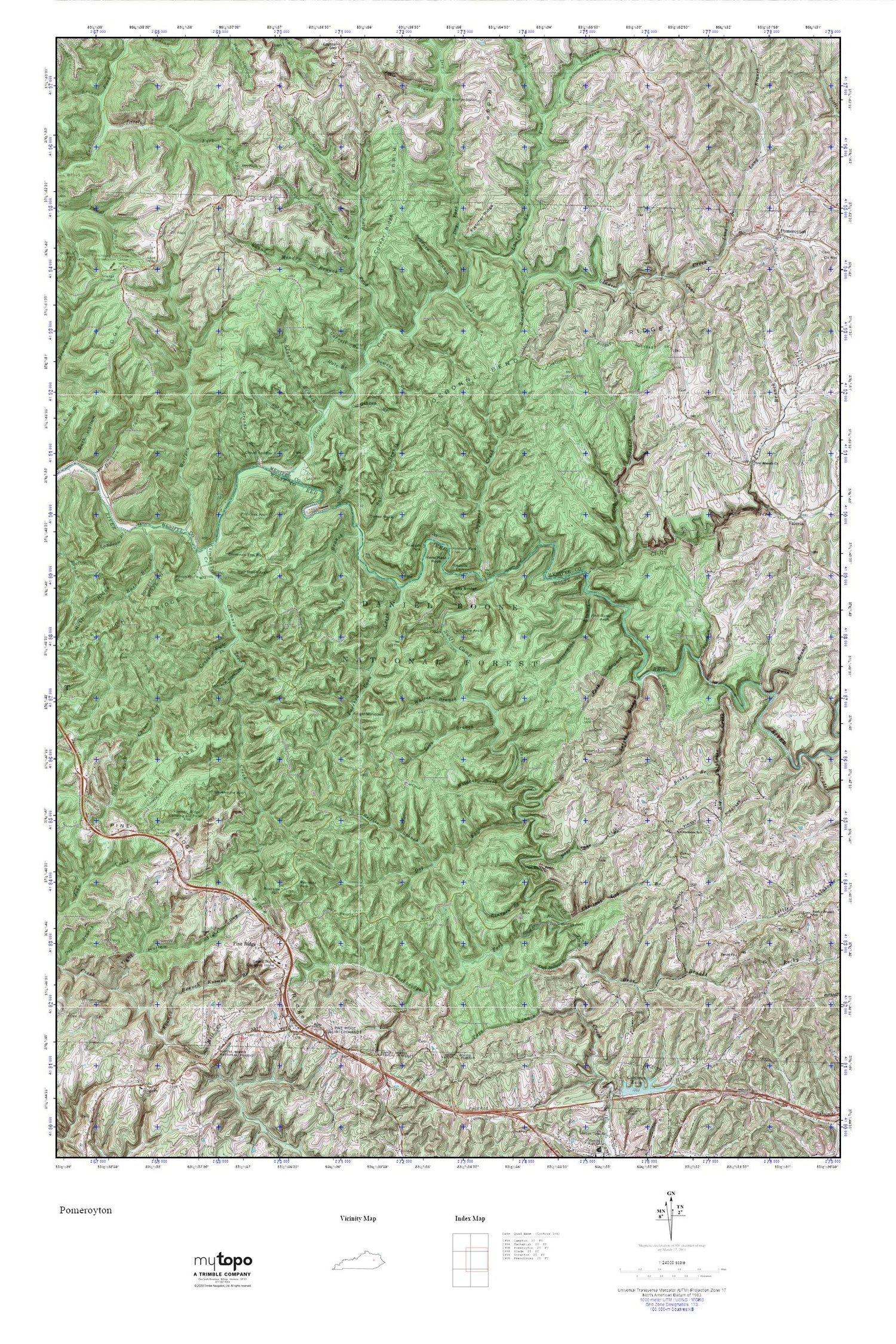
Topographic map of Pomeroyton in the state of Kentucky. From the MyTopo Explorer Series.
This topo map features shaded relief and comes with UTM / MGRS and Latitude/Longitude grids.
For more than two decades, MyTopo has provided maps to the most adventurous among us.. those who love to explore our nation’s remote wilderness areas, climb our highest peaks, and trek across our vast public lands. This map is part of a curated collection of the most popular places for which MyTopo customers have designed maps. It is a “bucket list” of the most amazing places to hike, hunt, and explore.
This map contains the following named places: 41360,Adena Arch,Alvan Drew School,Amphitheater Trail,Angel Windows,Banks Branch,Bear Branch,Bearpen Branch,Bell Branch,Big Calaboose Creek,Big Woods School,Browns Branch,Buck Trail,Calaboose Post Office,Calaboose Ridge,Calaboose School,Campbell Ridge,Cane Branch,Castle Arch,Center Cemetery,Chestnut Log Branch,Chimney Top Creek,Chimney Top Railroad Station,Chimney Top Rock,Clifty Creek,Clifty Wilderness,Cloud Splitter,Cloud Splitter Rock,Copperas Creek,Corner Ridge,Dessie Scott Childrens Home,Dog Fork,Dry Fork,Frenchburg Correctional Facility,Garrett Branch,Gibson Branch,Gladie Creek,Gladie Creek Gorge,Glendive Post Office,Greasy Branch,Green Garret Railroad Siding,Green Gose Branch,Hale Branch,Half Moon Arch,Half Moon Rock,Hardeman Post Office,Hells Kitchen,Hens Nest Rock,Hidden Arch,Indian Stairway,Josie Branch,King Branch,Klaber Branch,Koomer Branch,Koomer Ridge,Koomer Ridge Camping and Picnic Area,Koomer Ridge Trail,Landsaw Branch,Landsome Branch,Laurel Branch,Laurel Fork,Long Branch,Lost Branch,Mariba Fork,Middle Fork,Moonshiner Arch,Osborne Bend Ridge,Osborne Branch,Owl Hollow Branch,Page Branch,Parched Corn Creek,Peck Branch,Peniel Church,Pinch-Em Tight Gap,Pinch-Em Tight Trail,Pine Branch,Pine Branch Baptist Church,Pine Ridge,Pine Ridge Lookout Tower,Pine Ridge Post Office,Pine Ridge Railroad Station,Pine Ridge Visitor Center,Pomeroyton,Pomeroyton Cemetery,Pomeroyton Post Office,Pomeroyton Union Church,Powell Branch,Princess Arch,Red Wild and Scenic River,Red-byrd Arch,Reffits Branch,Right Fork Chimney Top Creek,Rock Bridge Arch,Rock Bridge Falls,Rock Bridge Picnic Area,Rock Bridge Trail,Rockbridge Fork,Rose Drake Branch,Rough Trail,Round Meadow Branch,Rush Branch,Sal Branch,Salt Fork,Sargent Branch,Sarges Branch,Silvermine Arch,Silvermine Arch Trail,Silvermine Branch,Sky Bridge,Sky Bridge Recreation Site,Solomon Branch,Sons Branch,Sulpher School,Swift Camp Creek,Swiftcamp Creek Trail,Tarr Ridge,Tarr Ridge Picnic Area,Tight Hollow,Timmons Arch,Tower Rock,Trimble Bend,Trimble Bend School,Turtle Back Arch,Twin Branch,United States Weather Station,Whistling Arch,Whites Branch,Wildcat Creek,Wildcat Trail,Wolfpen Creek


