MyTopo
Rabun Bald MyTopo Explorer Series Map
Couldn't load pickup availability
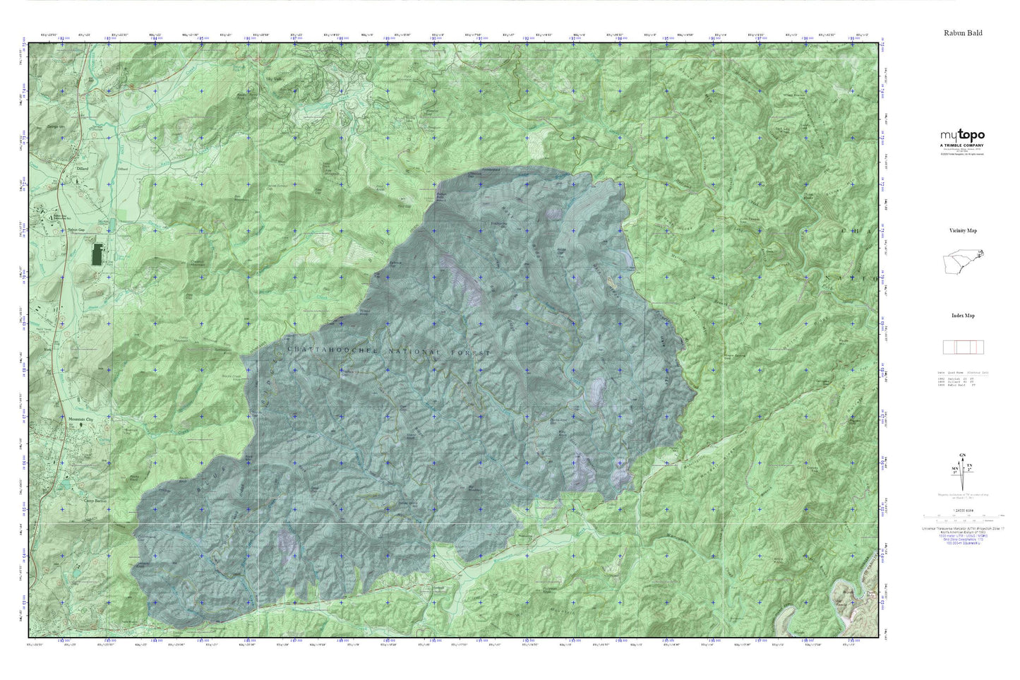
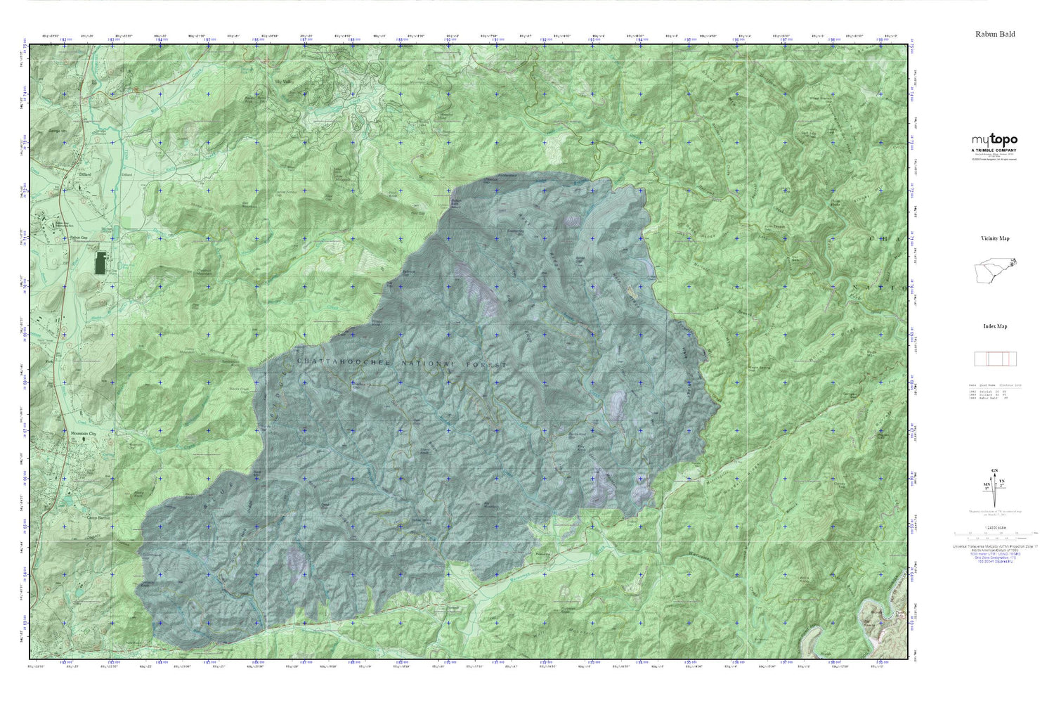
Topographic map of Rabun Bald in the state of Georgia. From the MyTopo Explorer Series.
This topo map features shaded relief and comes with UTM / MGRS and Latitude/Longitude grids.
For more than two decades, MyTopo has provided maps to the most adventurous among us.. those who love to explore our nation’s remote wilderness areas, climb our highest peaks, and trek across our vast public lands. This map is part of a curated collection of the most popular places for which MyTopo customers have designed maps. It is a “bucket list” of the most amazing places to hike, hunt, and explore.
This map contains the following named places: 30525,30537,30562,Addie Branch,Addie Gap,Alex Gap,Alex Mountain,Antioch,Antioch Church,Apple Valley,Bailey Branch,Beck Mountain,Beck Ridge,Beegum Gap,Ben Mountain,Bent Ridge,Betty Creek,Big Mountain,Big Ridge,Billingsley Creek,Blacks Branch,Blacks Creek,Blacks Creek Knob,Blackstump Gap,Blue Heights Church,Burrell Branch,Cabin Mountain,Camp Barron,Chestnut Gap,Chestnut Mountain,Chestnut Ridge,City of Dillard,Cold Mine Branch,Coldspring Gap,Courthouse Gap,Cox Lake,Cox Lake Dam,Dan Gap,Dan Ridge,Darling Spring,Darnell Creek,Deep Gap,Dillard,Dillard Police Department,Dillard Post Office,Double Knob,Ducks Nest Gap,Duncan Cemetery,Emory Branch,Flat Top,Flint Gap,Flint Knob,Fodderstack,George Mountain,Gibson Gap,Goble Gap,Hale Cemetery,Hale Church,Hale Church Cemetery,Hale Ridge,Hamby Cemetery,Head of Tennessee Baptist Church,High Top,Hogback,Hoods Creek,Hoojah Branch,Indian Grave Hill,Jerry Branch,John Teague Gap,Katy Knob,Kell Cemetery,Kelly Cemetery,Kelly Creek,Locust School Gap,Long Branch,Maple Spring Gap,Marsen Knob,Martin Creek,McCurry Cemetery,Meek Field,Metcalf Creek,Milksick Cove,Morsingills Creek,Mountain City,Mountain City Division,Mountain City Police Department,Mountain City Post Office,Mud Creek,Oakey Mountain,Owl Gap,Pine Gap,Pinnacle Knob,Pleasant Hill Church,Pollywah Knob,Pounding Mill Creek,Rabun Bald,Rabun Gap,Rabun Gap Academy,Rabun Gap Nacoochee School,Rabun Gap Nacoochee School Lake,Rabun Gap Nacoochee School Lake Dam,Rabun Gap Post Office,Rabun Gap Quarry,Rabun School Dam,Ramey Creek,Ramey Field,Rattlesnake Knob,Raven Knob,Rock Mountain,Rock Mountain Creek,Rock Ridge,Rocky Knob,Saltrock Gap,Sarahs Creek,Scrugg Gap,Sheep Cliff,Sheep Knob,Silver Branch,Smith Branch,Spring Lake,Stillhouse Branch,Sutton Branch,Thomas Creek,Thomas Field,Town of Mountain City,Tuckaluge Creek,Turkey Cove,Valley Volunteer Fire Station,WALH Radio Tower,WALH-AM (Mountain City),Wall Mountain,Walnut Fork,Warwoman Volunteer Fire Station,Warwoman Wildlife Management Area,Wesley Chapel Cemetery,Whiteoak Flats,Wild Hog Ridge,Wilson Gap,Wilson Knob,Windy Gap,Woodall Ridge,York