MyTopo
Crozet MyTopo Explorer Series Map
Couldn't load pickup availability
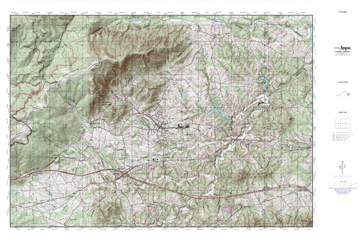
Topographic map of Crozet in the state of Virginia. From the MyTopo Explorer Series.
This topo map features shaded relief and comes with UTM / MGRS and Latitude/Longitude grids.
For more than two decades, MyTopo has provided maps to the most adventurous among us.. those who love to explore our nation’s remote wilderness areas, climb our highest peaks, and trek across our vast public lands. This map is part of a curated collection of the most popular places for which MyTopo customers have designed maps. It is a “bucket list” of the most amazing places to hike, hunt, and explore.
This map contains the following named places: 22943,Beagle Gap,Beagle Gap Overlook,Bear Den Mountain,Beaver Creek,Beaver Creek Mountain,Beaver Creek Number One Dam,Beaver Creek Reservoir,Beaver Creek Reservoir Park,Beaver Hill Mobile Home Park,Bermbergers Dam,Bermbergers Pond,Blair Park,Blue Ridge Acres,Broad Axe,Broad Axe Creek,Broad Axe School,Brooksville,Brookville Tunnel,Brookwood,Brownsville,Brownsville Elementary School,Bucks Elbow Mountain,Calf Mountain,Calf Mountain Overlook,Casa Maria,Clover Farm,Cornerstone Church of Albemarle,Cottonwood Farm Airport,Country View,Crozet,Crozet Baptist Church,Crozet Census Designated Place,Crozet Elementary School,Crozet Methodist Church,Crozet Post Office,Crozet Volunteer Fire Department Station 5,Crozet Water Supply Dam,Crozet Water Supply Reservoir,Dry Bridge,Emmanuel Cemetery,Emmanuel Church,Foothill Village,Freetown,Garnett Dam,Gillums Mountain,Glenaire,Greenwood,Greenwood Hollow,Greenwood Post Office,Greenwood School,Greenwood Tunnel,Henleys Dam,Henleys Lake,Hillsboro Cemetery,Hillsboro Church,Ivy Meadows,Ivy Woods,J T Henly Middle School,James Oldham Ordinary,Jarman Gap,Jarmans Mill,Lake Albemarle,Lake Albemarle Dam,Lake Road Church,Laurel Hills,Lebanon Cemetery,Lebanon Presbyterian Church,Lickinghole Creek,Little Yellow Mountain,Mad Run,Meadow Branch Hollow,Mechums River,Midway,Midway School,Mint Springs Recreation Area,Mirador,Mirador Heliport,Mount Olivet Cemetery,Mount Plains Cemetery,Mount Plains Church,Mount Salem Cemetery,Mount Salem Church,Mount Zion Church,Newtown,Orchard Acres,Parkview,Parrott Branch,Peacock Hill,Peacock Hill Dam,Piedmont,Piedmont Church,Pounding Branch,Powells Creek,Ramsey,Rock Gate Cemetery,Rosehill,Saddle Hollow,Sawmill Ridge Overlook,Sawmill Ridge Trail,Sawmill Run Overlook,Sawmill Run Shelter,Seven Oaks Farm,Skyline Crest,Slabtown Branch,Sneads Mobile Home Park,Spring Creek,Stockton Creek,Stony Run,Tabor Presbyterian Church,Temple Hill,The Cedars,The Country Store,The Longhouse,The Meadows,Thurston,Tiverton,Tuckedaway Branch,Union Baptist Church,WANV-FM (Staunton),Watts Branch,Wayland Park,WCYK-AM (Crozet),WCYK-FM (Crozet),Western Albemarle High School,Western Albemarle Rescue Squad Station 5,Westover Hills,Whispering Pines,Whites Dam,Whites Pond,Will Woods Branch,Windy Hill,WVTU-FM (Charlottesville),Yancey Mills,Yellow Mountain,Yellow Mountain Creek