
MyTopo
Isle Au Haut West MyTopo Explorer Series Map
Couldn't load pickup availability
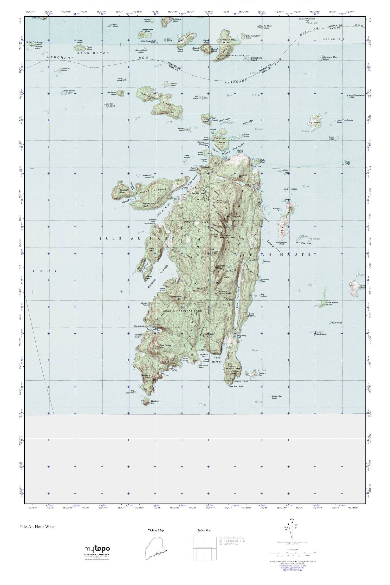
Topographic map of Isle Au Haut West in the state of Maine. From the MyTopo Explorer Series.
This topo map features shaded relief and comes with UTM / MGRS and Latitude/Longitude grids.
For more than two decades, MyTopo has provided maps to the most adventurous among us.. those who love to explore our nation’s remote wilderness areas, climb our highest peaks, and trek across our vast public lands. This map is part of a curated collection of the most popular places for which MyTopo customers have designed maps. It is a “bucket list” of the most amazing places to hike, hunt, and explore.
This map contains the following named places: 04645,Airy Ledge,Bald Mountain,Barred Harbor,Barter Creek,Barter Island Ledges,Battery Island,Bay West,Big Brewster,Bills Island,Birch Point,Black Dina,Black Dina Trail,Black Ledges,Blackhorse Island,Boom Beach,Bowditch Trail,Bull Brook,Burnt Island,Burnt Island Thorofare,Burnt Ledge,Cape Ann Ledge,Channel Rock,Cliff Trail,Colby Ledge,Colby Pup,Coombs Mountain,Deep Cove,Dodges Cove,Doliver Island,Duck Brook,Duck Harbor,Duck Harbor Campground,Duck Harbor Cemetery,Duck Harbor Landing,Duck Harbor Ledge,Duck Harbor Mountain,Duck Harbor Trail,Eastern Ear Island,Eastern Ear Ledge,Eastern Head,Ebens Head,Ebens Head Trail,Edies Trail,Ewe Island,Farrel Island,Flake Island,Flat Ledge,Fog Island,George Head Island,George Head Ledge,Gooseberry Island,Goss Beach,Great Meadow,Haddock Ledge,Halfway Rock,Harbor Island,Harbor Island Ledge,Hardwood Island,Head Harbor,Horseman Ledge,Horseman Point,Horseman Point Trail,Isle Au Haut,Isle Au Haut Light Station,Isle Au Haut School,Isle Au Haut Thorofare,Jerusalem Mountain,Jerusalem Mountain Trail,Keeler Rock,Kimball Head,Kimball Island,Kimball Rock,Laundry Cove,Leach Rock,Little George Head Island,Little McGlathery Island,Little Spoon Island,Long Pond,Lookout,Lookout Point,Marsh Cove,Marsh Cove Head,Marsh Cove Ledges,McGlathery Island,Merchant Brook,Merchant Island,Merchant Island Cemetery,Merchant Row,Merchants Cove,Merchants Point,Middle Ledges,Moores Harbor,Moores Harbor Ledge,Moores Head,Mount Chaplain,Mouse Island,Moxie Island,Nathan Island,National Merchant Trail,Negro Head,Northwest Cove,Old Cove,Old Cove Trail,Pats Brook,Pell Island,Pell Island Passage,Pond Point,Popplestone Point,Rabbits Ear,Ram Island,Ram Island Ledge,Revere Memorial Library,Richs Cove,Richs Ledge,Richs Point,Roaring Bull Ledge,Robinson Point,Rock T,Rocky Mountain,Rosebud Island,Round Island,Sawyer Ledge,Sawyer Mountain,Sawyer Notch Trail,Scraggy Ledge,Seal Ledges,Seal Point Trail,Sharks Point,Sheep Thief Gulch,Southern Mark Island,Sparrow Island,Squeaker Cove,Steve Island,The Bandies,The Cow Pen,The Seal Trap,The Washers,Thunder Gulch,Thunder Gulch Trail,Town of Isle au Haut,Trail Point Trail,Trial Point,Trial Point Ledge,Turners Cemetery,Turnip Yard,Wentworth Mountain,West Halibut Ledges,West Malibu Ledges,Western Ear Island,Western Ear Ledge,Western Head,Western Head Trail,Wheat Island,Whitehorse Island,Wreck Island,York Island,York Ledges


