MyTopo
Elk Park MyTopo Explorer Series Map
Couldn't load pickup availability
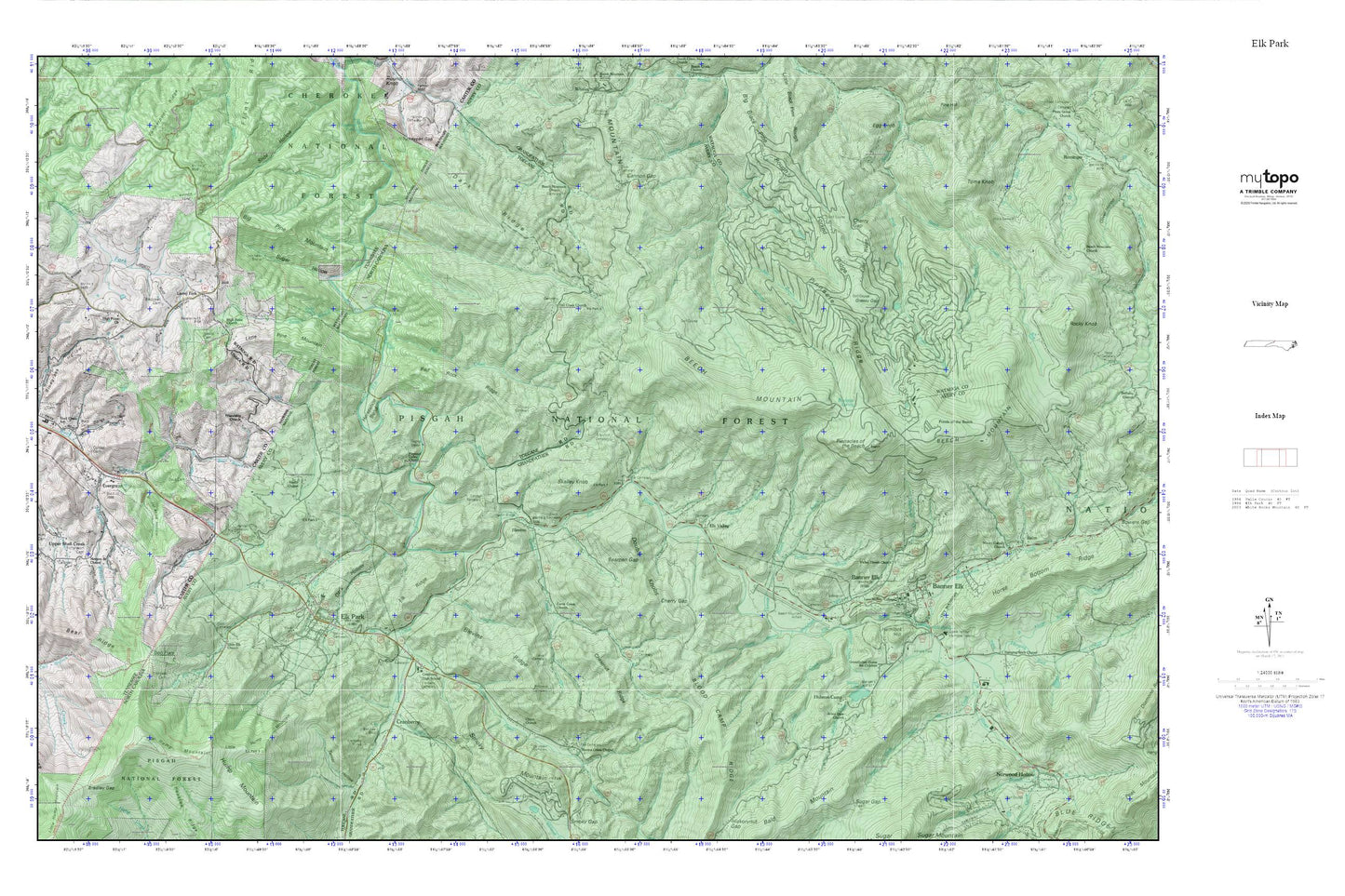
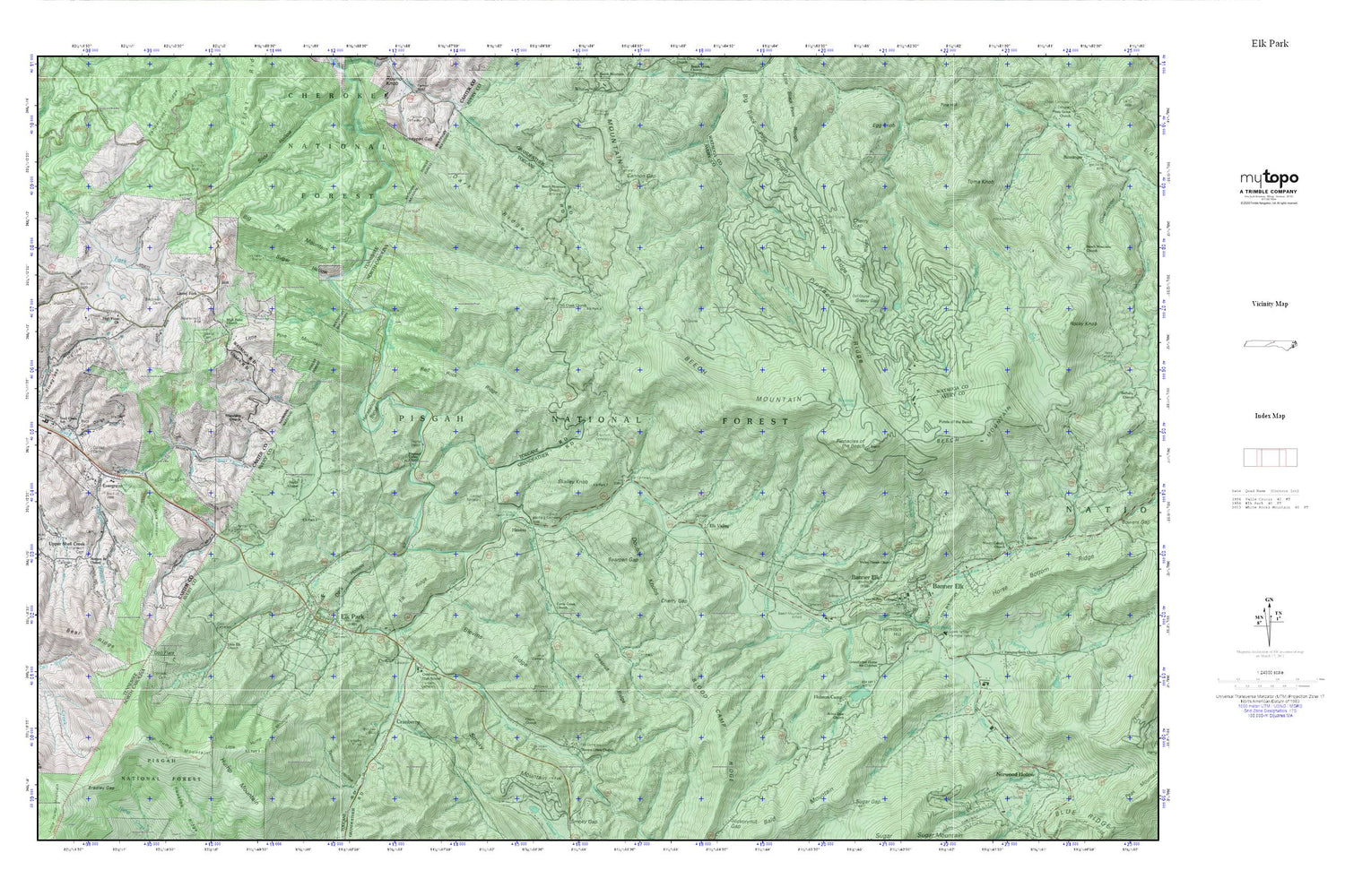
Topographic map of Elk Park in the states of North Carolina, Tennessee. From the MyTopo Explorer Series.
This topo map features shaded relief and comes with UTM / MGRS and Latitude/Longitude grids.
For more than two decades, MyTopo has provided maps to the most adventurous among us.. those who love to explore our nation’s remote wilderness areas, climb our highest peaks, and trek across our vast public lands. This map is part of a curated collection of the most popular places for which MyTopo customers have designed maps. It is a “bucket list” of the most amazing places to hike, hunt, and explore.
This map contains the following named places: 28604,28622,Arbor Dale Church,Avery County Emergency Medical Services Banner Elk Station,Avery County Emergency Rescue Squad Ambulance Service,Banner Cemetery,Banner Elk,Banner Elk Elementary School,Banner Elk Police Department,Banner Elk Post Office,Banner Elk Volunteer Fire and Rescue,Bear Branch,Bear Ridge,Bearpen Gap,Beech Creek School,Beech Mountain,Beech Mountain Church,Beech Mountain Police Department,Beech Mountain Volunteer Fire Department - Station 2,Beech Mountain Volunteer Fire Department Station 1,Big Black Pine Rough,Big Falls,Big Pine Mountain,Blackwell Cemetery,Blevins Creek,Blevins Creek Chapel,Blevins Ridge,Blood Camp Ridge,Bluegrass Hollow,Buck Cemetery,Buck Mountain,Buck Mountain School,Buckeye Spring,Cannon Cemetery,Cannon Gap,Caraway Cemetery,Cherokee Wildlife Management Area,Cherry Gap,Chestnut Ridge,Cook Cemetery,Cooper Branch,Cordell Cemetery,Cranberry,Cranberry Cemetery,Cranberry Creek,Cranberry Dam,Cranberry High School,Cranberry Lake,Cranberry Mines,Crawford Cemetery,Curtis Creek,Curtis Creek Church,Dark Hollow,Dark Ridge,Dolan Hollow,Doll Branch,Doll Flats,Don Nelan Appalachian Trail Shelter,Double Knobs,Elk Falls Point of Interest,Elk Park,Elk Park Elementary School,Elk Park Post Office,Elk Park Volunteer Fire Department,Elk Ridge,Elk River Airport,Elk Valley,Eller Cemetery,Ellis Cemetery,Evergreen,Evergreen Freewill Baptist Church,Fall Creek,Fall Creek Church,Fall Creek Volunteer Fire Department Station 1,Forked Ridge,Fox Cemetery,Friendship Church,Grace Hartley Memorial Hospital,Grandfather Home for Children,Grassy Gap,Grassy Gap Creek,Greenbrier Creek,Hanging Rock Chapel,Hanging Rock Creek,Heaton,Heaton Bridge,Hemlock Hill,Hicks Cemetery,High Point Church,Holston Camp,Holtsclaw Cemetery,Horney Branch,Horse Bottom Creek,Horseshoe Bend,Houston Ridge,Hump Mountain,Isaacs Cemetery,Jones Branch,Jones Cemetery,Jones Falls,Laban,Laurel Fork,Laurel Fork School,Laws Cemetery,Lee Branch,Lee Cemetery,Lees-McRae College,Leroy Creek,Little Black Pine Rough,Little Elk Church,Little Elk Creek,Little Hump Mountain,Little Pine Mountain,Lost Ridge,McClain Cemetery,Mill Creek,Mill Pond,Miller Branch,Miller Hollow,Morgan Branch,Morgan Branch Chapel,Mount Calvary Church,Oaks Cemetery,Palmer Cemetery,Peavine Branch,Perkins Cemetery,Perkins Hollow,Perry Cemetery,Pinnacle Ridge,Pinnacles of the Beech,Pisgah Game Lands,Pleasant Valley Church,Pond Creek,Ponds of the Beech,Potts Cemetery,Pritchard Cemetery,Puckett Branch,Ramp Branch,Red Rock Ridge,Richardson Cemetery,Sawmill Branch,Shawneehaw Creek,Shell Creek School,Skalley Branch,Skalley Knob,Smith Cemetery,State Line Branch,Sugar Creek,Sugar Hollow,Sunrise View Church,Taylor Chapel,Toms Knob,Town of Banner Elk,Town of Beech Mountain,Town of Elk Park,Township of Banner Elk,Township of Cranberry,Township of Elk Park,Township of Heaton,Trivett Cemetery,Union Church,Upper Shell Creek,Upper Shell Creek Christian Church,Upper Shell Creek School,Valley Haven Church,Whitehead Creek,Wildcat Creek,Wildcat Lake,Wilder Mine Hollow,Wilson Cemetery,Winter Hollow,Winters Cemetery