MyTopo
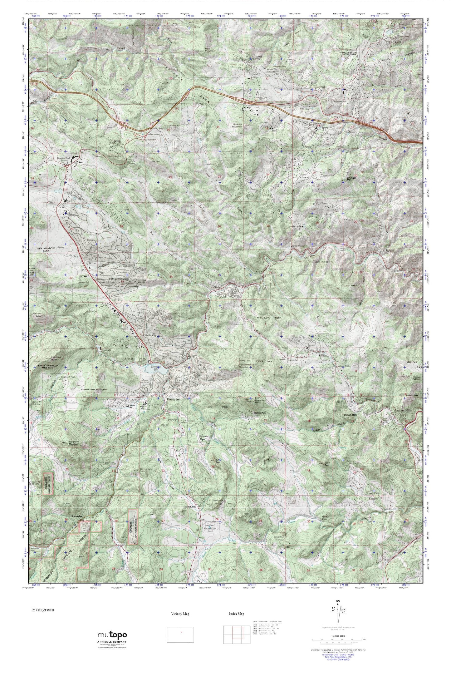
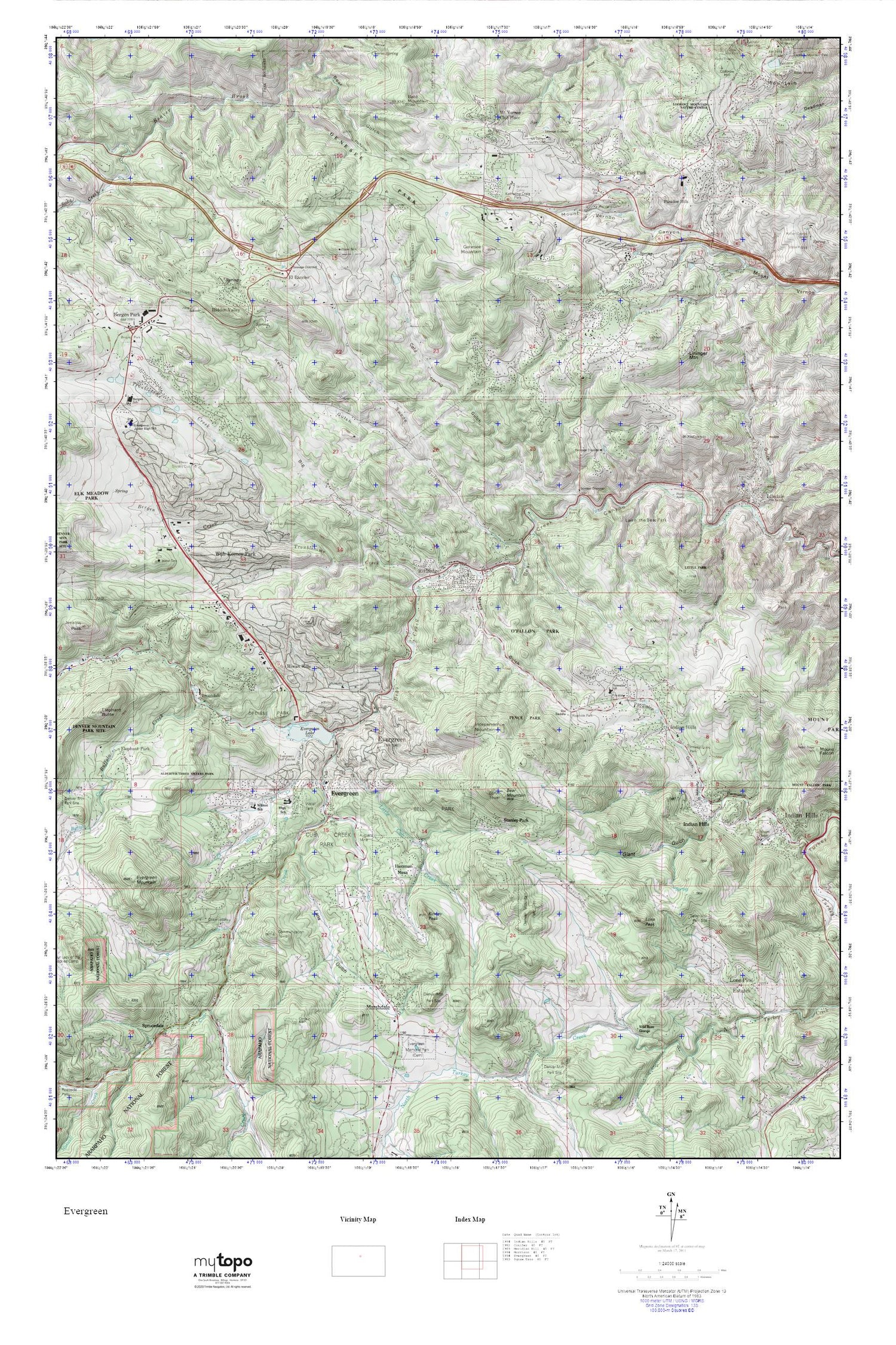
Evergreen MyTopo Explorer Series Map
Couldn't load pickup availability
Topographic map of Evergreen in the state of Colorado. From the MyTopo Explorer Series.
This topo map features shaded relief and comes with UTM / MGRS and Latitude/Longitude grids.
For more than two decades, MyTopo has provided maps to the most adventurous among us.. those who love to explore our nation’s remote wilderness areas, climb our highest peaks, and trek across our vast public lands. This map is part of a curated collection of the most popular places for which MyTopo customers have designed maps. It is a “bucket list” of the most amazing places to hike, hunt, and explore.
This map contains the following named places: 80453,80454,80457,Alderfer/Three Sisters Park,Arrowhead Community Park,Augusta Mine,Bald Mountain,Bear Creek Quarry,Bear Mountain,Beaver Brook Trail,Bell Park,Bergen Creek,Bergen Meadow Elementary School,Bergen Park,Bergen Park Evangelical Free Church,Big Gulch,Blue Creek,Buffalo Creek,Burroughs Feldspar Mine,Capitol Central Mine,Central Jefferson Division,Christ The King Catholic Church,Church of the Hills,Church of the Transfiguration,Church of the Transfiguration Cemetery,Cody Park,Cold Spring Gulch,Corwina Park,Cub Creek,Cub Creek Park,Dedisse Park,Devils Gulch,Dix Saddle,El Rancho,Elephant Park,Evergreen,Evergreen Cemetery,Evergreen Census Designated Place,Evergreen Dam,Evergreen Fire / Rescue Station 1,Evergreen Fire / Rescue Station 2,Evergreen Fire / Rescue Station 3,Evergreen Fire / Rescue Station 4,Evergreen Fire Rescue Station 6,Evergreen Fluorite Deposit Mine,Evergreen Golf Course,Evergreen Lake,Evergreen Middle School,Evergreen Mountain,Evergreen Post Office,Fillius Park,First Baptist Church,First Church of Christ Scientist,Foothill Mine,Foothills Fire and Rescue Department Mount Vernon Substation,Foothills Fire and Rescue Grapevine Substation,Foothills Fire and Rescue Idledale Station,Foothills Fire and Rescue Lookout Mountain Station,Foothills Fire and Rescue Rainbow Hills Station,Foothills Mine,Genesee,Genesee Camp,Genesee Census Designated Place,Genesee Fire and Rescue,Genesee Mountain,Genesee Park,Genesee Ridge,Genesee Sewage Treatment Dam,Genesee Sewage Treatment Reservoir,Giant Gulch,Gilmore Chapel,Grapevine Mine,Herzman Mesa,Hidden Valley,Highland Rescue Team Ambulance Station,Hiwan Country Club,Hiwan Hills,Hiwan Homestead Museum,Hiwan Number 1 Dam,Hiwan Number 1 Reservoir,Hiwan Number 6 Dam,Hiwan Number 6 Reservoir,Idledale,Idledale Census Designated Place,Idledale Post Office,Independence Mountain,Indian Hills Census Designated Place,Indian Hills Fire / Rescue,Indian Hills Fire Department Heliport,Indians Hills,Jefferson County,Jefferson County Sheriff's Office Mountain Precinct,Katherine Craig Park,Kerr Gulch,Kinney Peak,Kittredge,Kittredge Census Designated Place,Kittredge Post Office,Lair o' the Bear Park,Lans Gulch,Lininger Mountain,Little Cub Creek,Little Park,Lone Peak,Lone Pine Estates,Lookout Mountain Nature Center,Lutheran Church of the Cross,Marshdale,Morton Heliport,Mount Vernon Club Place,Mount Vernon Country Club,Mountain Meadow Heights,Mountain Song Foursquare Church,Myers Gulch,O'Fallon Park,Panorama Heights,Paradise Hills,Parmalee Elementary School,Parmalee Gulch Park,Pence Park,Rainbow Hills,Ralston Elementary School,Riva Chase,Rockland Cemetery,Sawmill Gulch,Seven Hills-Yetter Ranch Pegmatite Quarry,Shingle Creek,Silver Glen Ranch Pegmatite Quarry,Soda Creek,Spring Ranch,Sprucedale,Stanley Park,Sunrise Peak Mine,Sunrise Peak Pegmatite Quarry,Swede Gulch,Swede-Kerr Gulches Pegmatite Quarries,Tall Timber Airport,Troublesome Creek,Troutdale,Wah Keeney Park,Wasson Beryl Deposit,Wasson Ranch Pegmatite Quarry,Wild Rose Grange,Wilmot Creek,Wilmot Elementary School,Wright Lease Mine