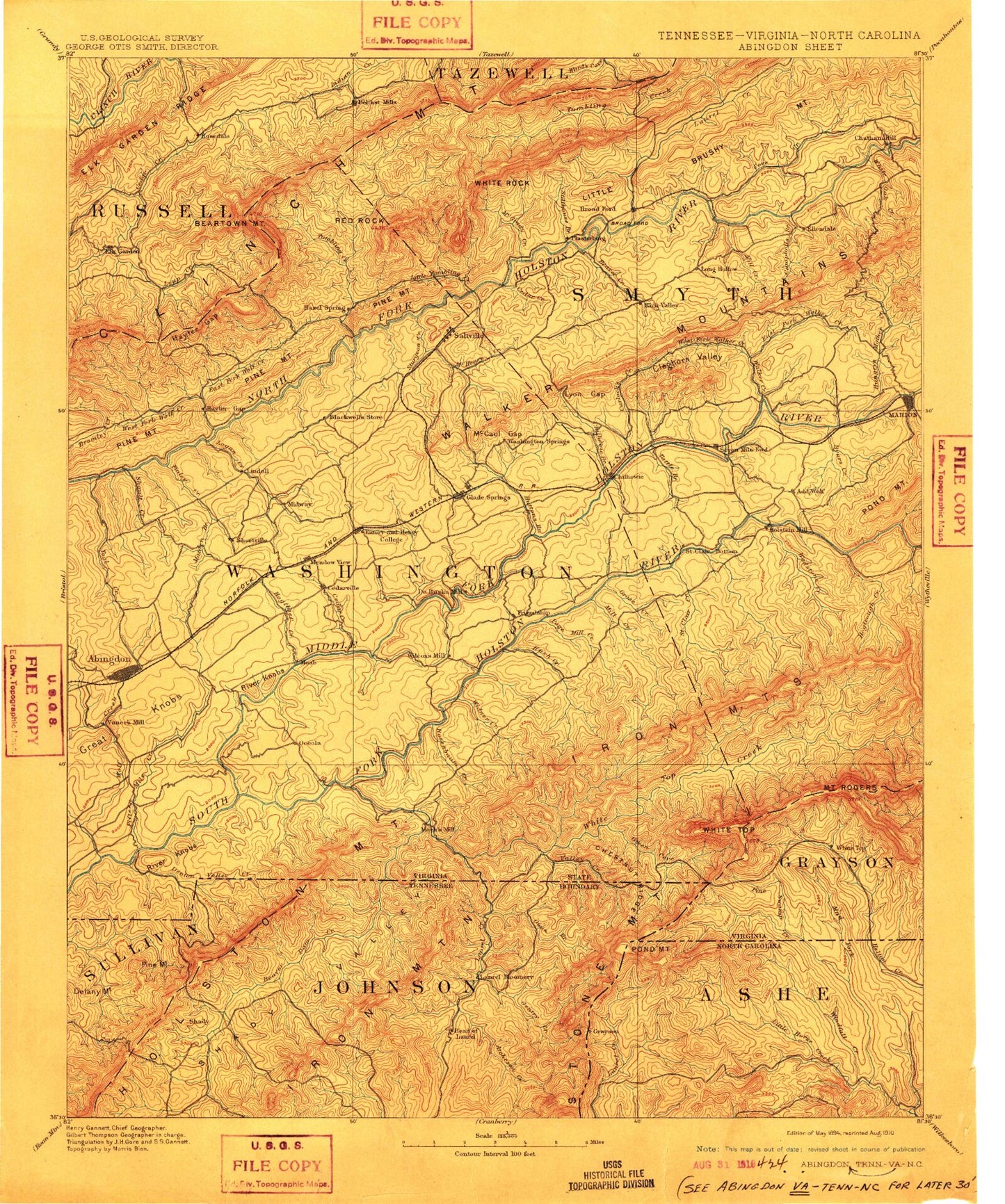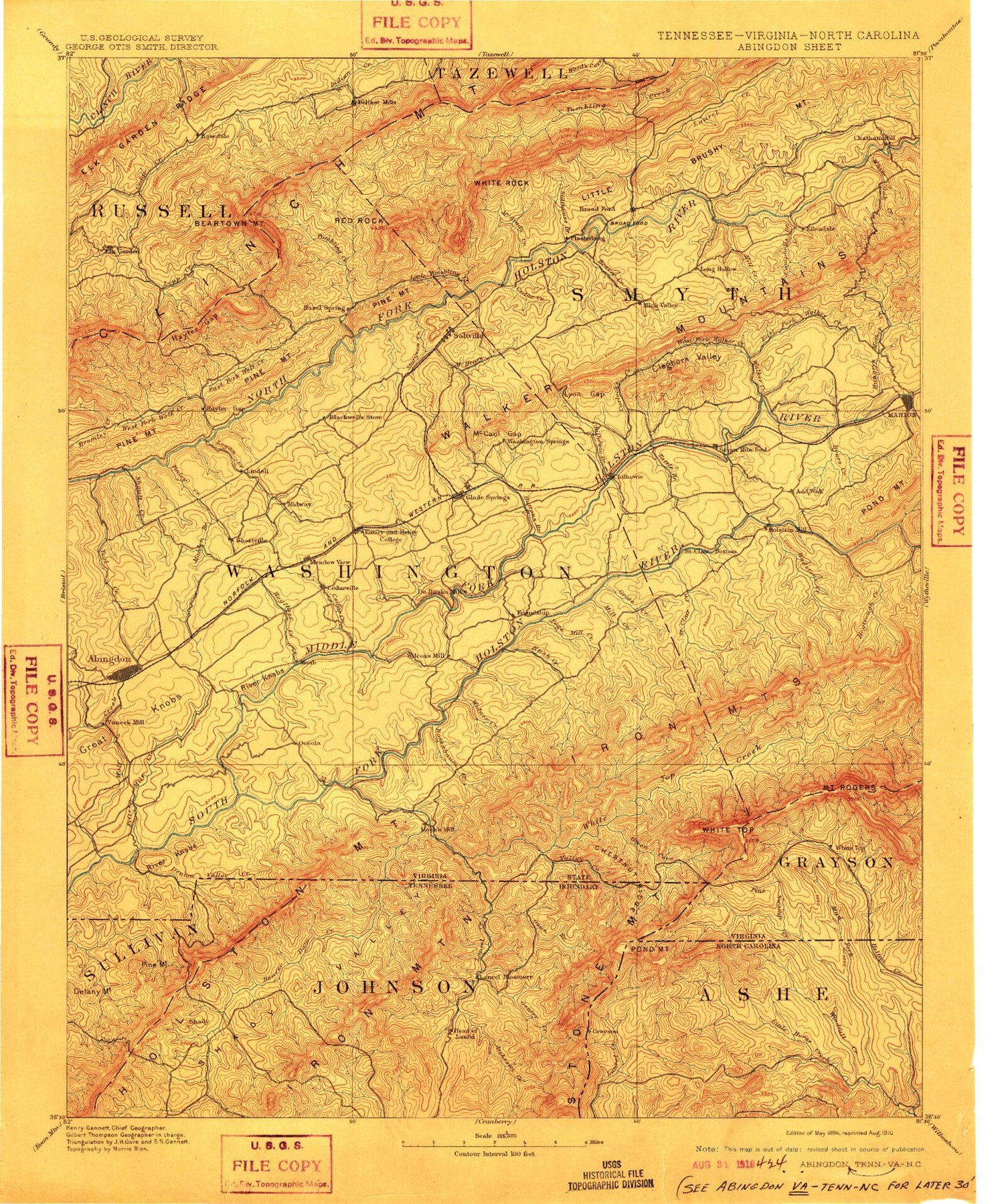
MyTopo
Historic 1894 Abingdon Virginia 30'x30' Topo Map
Couldn't load pickup availability
Historical USGS topographic map of Abingdon in the state of Virginia. Scale: 1:125000. Print size: 17" x 24"
This map was published in 1894 and is in the following counties: Ashe, Carter, Grayson, Johnson, Russell, Smyth, Sullivan, Tazewell, Washington.
The map contains contour lines, roads, rivers, towns, streams, and lakes. Printed on high-quality waterproof paper with UV fade-resistant inks.
Contains the following named places: Baldwin Branch, Fees Branch, Mud Creek, Stone Mountains, Laurel Creek, Bearpen Ridge, Buckeye Branch, Davis Hollow, Elliot Branch, High Trestle Branch, Holston Valley, Beetree Branch, Berrys Creek, Big Low Gap, Blind Hollow, Brindle Hollow, Bumgardner Branch, Campbell Hollow, Carlock Creek, Cherry Orchard Hollow, Chilhowie, Cleghorn Valley Creek, Crooked Branch, Dry Branch, Fall Hollow, Gill Hollow, Great Knobs, Greever Branch, High Trestle Branch, Horseshoe Bend, Jamison Gap, Jordan Hollow, Latture Field, Little Low Gap, Lyons Gap, McHenry Creek, McQueen Branch, McQueen Gap, Pendleton Branch, Plum Creek, River Knobs, Saint Clair Bottom, Sand Ridge, Shular Hollow, Southwest Virginia 4-H Center, Spoon Gap Creek, Stone Coal Hollow, Sulphur Spring Creek, Tattle Branch, Town Creek, Valley Creek, Watauga Valley, White Branch, Wood Hollow, Alvarado, Watauga, Allen Hollow, Allison Gap, Back Fork, Baker Branch, Baker Branch, Baker Hollow, Baker Ridge, Bark Camp Branch, Barnett Hollow, Barton Branch, Barton Gap, Bear Branch, Bear Ridge, Bear Tree Gap, Beartown Branch, Beaver Creek, Beaverdam Creek, Beech Creek, Bell Hollow, Bently Hole, Bethany Creek, Big Branch, Big Creek, Big Hill, Big Knob Ridge, Big Laurel Creek, Bills Ridge, Bishop Branch, Blackwell Branch, Blevins Branch, Blue Grass Trail, Bowman Branch, Braudy Branch, Brier Cove, Brier Ridge, Broadwine Branch, Broady Bottom, Brown Gap, Brumley Ridge, Brush Creek, Buckeye Hollow, Buckhorn Ridge, Bucks Branch, Burgess Creek, Burnt Cabin Hollow, Burnt Hill, Buzzard Den Branch, Buzzard Den Branch, Buzzard Den Ridge, Byars Creek, Byers Creek, Cabin Creek, Cabin Ridge, Camp Cedars, Camp Pocahontas, Campbell Creek, Casey Hollow, Cedar Branch, Cedar Creek, Charles Branch, Chatham Hill, Cherry Tree Camp, Cherry Tree Gap, Chestnut Branch, Chestnut Flats, Chestnut Hollow, Chestnut Ridge, Chestnut Ridge, Chestnut Ridge, Chestnut Ridge, Chestnut Ridge, Clark Mountain Trail, Cleghorn Valley, Clinch Mountain Spur, Clinch Mountain State Wildlife Management Area, Clyburn Hollow, Cold Branch, Collins Hollow, Comers Branch, Cooley Camp Branch, Count Branch, Count Creek, Counts Cove, Cove Ridge, Cox Mill Creek, Cranshaw Hollow, Creasy Hollow, Crewey Branch, Cullop Branch, Cursing Hollow, Damascus, Daves Branch, Daves Ridge, Davis Hollow, DeBusk Hollow, Deans Branch, Deep Gap, Denton Valley, Doane Hollow, Double Spring Branch, Dry Branch, Dry Branch, Dry Branch, Dry Branch, Dry Fork, Dry Run, Dunford Ridge, East Fork Cedar Creek, East Fork Hall Creek, East Fork Hopkins Branch, East Fork Wolf Creek, Edington Branch, Edington Cove, Elk Garden, Elk Garden, Elk Garden Ridge, Elk Ridge, Elkhorn Branch, Emory, Feathercamp Branch, Feathercamp Ridge, Fees Ridge, Fifteenmile Creek, Finley Creek, Fisher Hollow, Fogleman Branch, Frank Coe Hollow, Fullen Branch, Gimlet Branch, Glade Spring, Gobble Branch, Grable Branch, Grant Hollow, Grassy Branch, Grassy Hollow, Greasy Rock Hollow, Green Cove Creek, Greenway Branch, Greenway Creek, Grindstone Branch, Grosses Creek, Halfmile Creek, Hall Creek, Halls Cove, Hanger Hollow, Hardscrabble Hollow, Hayters Gap, Hayters Gap, Helton Hollow, Henry Widener Branch, Hess Hollow, Hogtrough Hollow, Hogwallow Branch, Holston Mill, Holt Hollow, Honey Locust Branch, Honey Locust Knobs, Hooks Branch, Hopkins Branch, Horseshoe Bend, Horseshoe Bend, Horton Valley, Howard Hollow, Hubbard Branch, Hubbard Hole, Hungry Mother Creek, Hungry Mother State Park, Hurley Hollow, Hurricane Gap, Hutton Creek, Incline Hollow, Indian Run, Iron Mountain Trail, Jerrys Creek, Jinkerson Branch, Joe Doss Hollow, John Hess Hollow, Johnson Hollow, Kelly Ridge, Ketchum Branch