MyTopo
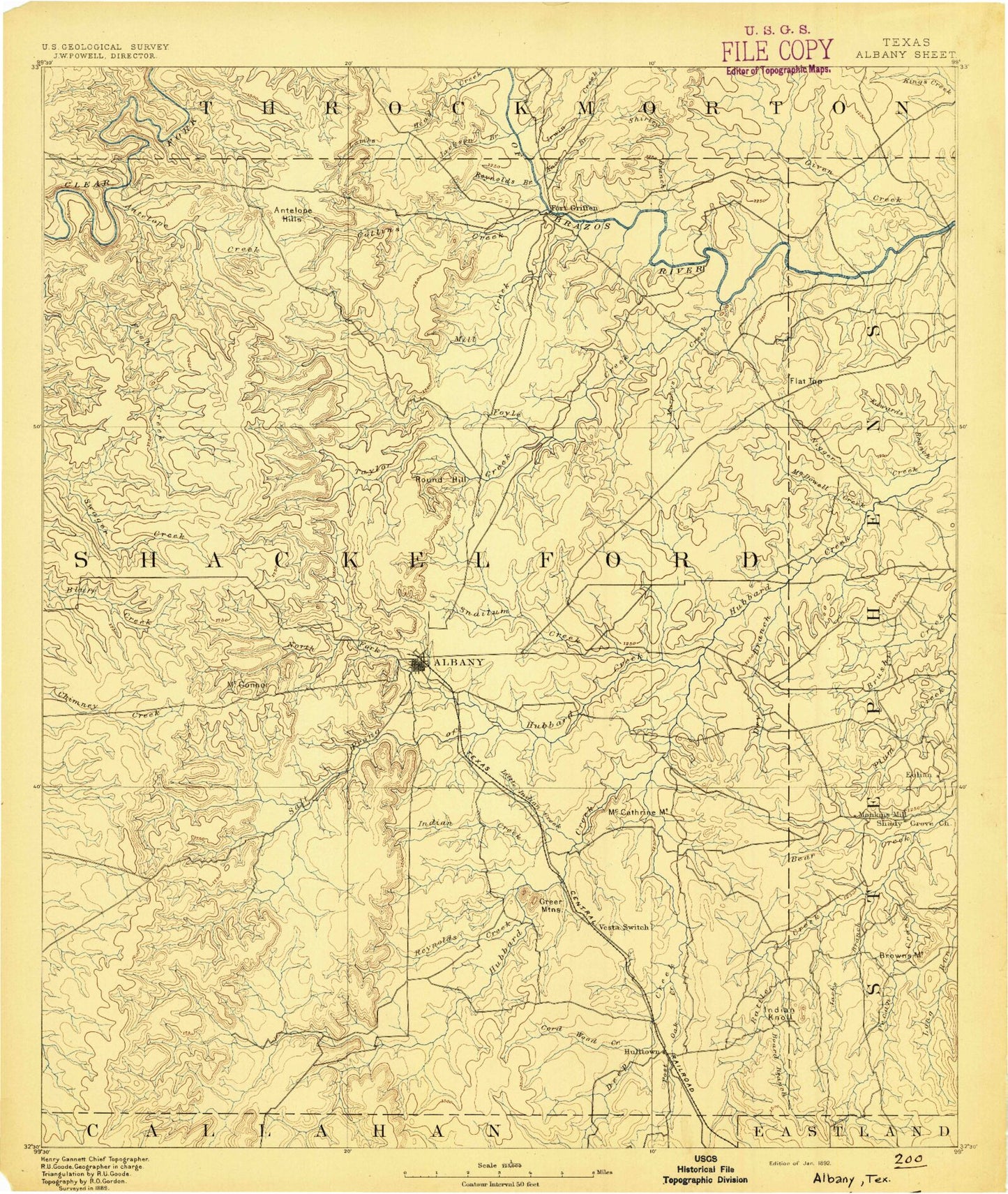
Historic 1892 Albany Texas 30'x30' Topo Map
Couldn't load pickup availability
Historical USGS topographic map of Albany in the state of Texas. Scale: 1:125000. Print size: 17" x 24"
This map was published in 1892 and is in the following counties: Callahan, Eastland, Haskell, Shackelford, Stephens, Throckmorton.
The map contains contour lines, roads, rivers, towns, streams, and lakes. Printed on high-quality waterproof paper with UV fade-resistant inks.
Contains the following named places: Hubbard Creek Lake, Albany, Antelope Creek, Antelope Hills, Battle Creek, Bear Branch, Board Branch, Brown Mountain, Brushy Creek, Cat Branch, Collins Creek, Cook Camp, Cook Creek, Cook Ranch, Cordwood Creek, De La Fosse Lake, Deadman Draw, Deep Creek, Diller Lake, Dry Branch, Edwards Branch, Eubanks Creek, Flat Rock Creek, Flat Top, Flat Top, Fort Griffin State Park, Foyle Creek, Gray Mountain, Greer Mountains, Hog Branch, Ibex Oil Field, Indian Creek, Indian Knoll, Jacks Branch, Jackson Branch, Lambshead Creek, Leeper Creek, Little Indian Creek, Long Run, Matthews Ranch, McCathrine Mountain, McDowell Creek, Meeks Branch, Mill Creek, Moran, Murphy Creek, Nail Ranch, Negro Creek, Newcomb Creek, North Fork Salt Prong Hubbard Creek, O'Neal Oil Field, Palm Ranch, Pecan Creek, Plum Branch, Plum Branch, Post Oak Creek, Red Gap, Reynolds Branch, Reynolds Creek, Round Hill, Round Top Mountain, Shirley Branch, Snailum Creek, Snyder Lake, Stagestand Branch, Taylor Creek, The Island, Webb Memorial Park, Wolf Creek, Brushy Branch, Buck Branch, Jenkins Creek, McCarty Lake, Middle Kings Creek, Mugginsville Mountain, Salt Prong Hubbard Creek, South Branch McDowell Creek, Woodson Oil Field, Acampo, Eolian, Eureka, Fort Griffin, Mankins Mill, Sedwick, Lusk, Shackelford County, Ibex Pumping Station, Wylie Lake Dam, Wylie Lake, Moran City Lake Dam, Moran Lake, Johnson Lake Dam, Johnson Lake, Stassney Lake Dam, Stassney Lake, Lake de La Fosse Dam, Elliot Lake Dam, Elliot Lake, Diller Lake Dam, McCarty Lake Dam, Casey Lake Dam, Casey Lake, Nail Lake Number 1 Dam, Nail Lake Number 1, Nail Lake Number 2 Dam, Nail Lake Number 2, Green Reservoir Number 1 Dam, Green Reservoir Number 1, Green Reservoir Number 2 Dam, Green Reservoir Number 2, Pico Lake Dam, Pico Lake, McCowan Lake Dam, McCowan Lake, Taylor Lake Dam, Taylor Lake, Texas Company Lake Dam, Hubbard Creek Reservoir, Lester Clark Dam, Stevens Company Water Company Lake Dam, Stevens Company Water Company Lake, Lambshead Tank Dam, Lambshead Tank, Vanzandt Lake Number 1 Dam, Vanzandt Lake Number 2, Vanzandt Lake Number 2 Dam, Vanzandt Lake Number 2, Albany Division, Moran Division, Fort Griffin State Historical Park, Shackelford County Courthouse Historic District, Fort Griffin State Historical Park Trail, Eureka, City of Albany, City of Moran