MyTopo
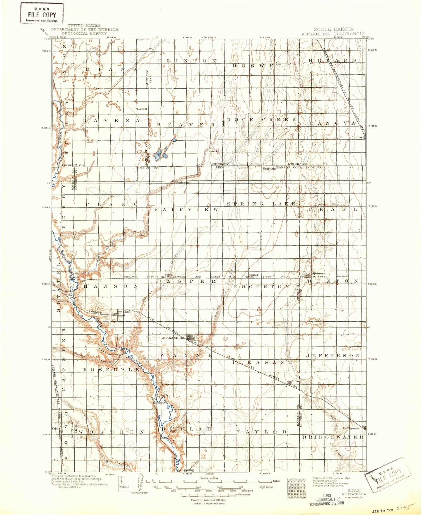
Historic 1899 Alexandria South Dakota 30'x30' Topo Map
Couldn't load pickup availability
Historical USGS topographic map of Alexandria in the state of South Dakota. Scale: 1:125000. Print size: 18" x 24"
This map was published in 1899 and is in the following counties: Davison, Hanson, McCook, Miner, Sanborn.
The map contains contour lines, roads, rivers, towns, streams, and lakes. Printed on high-quality waterproof paper with UV fade-resistant inks.
Contains the following named places: Gross Lake State Public Shooting Area, Alexandria, Bitter Lake, Bitter Lake State Public Shooting Area, Bloom Creek, Bridgewater, Burke Slough, Burke Slough State Public Shooting Area, Dry Run, Dry Run, Dry Run, Ediger State Public Shooting Area, Lake Eli, Emery, Enemy Creek, Ethan, Ethan Lake, Farmer, Firesteel Creek, Forsch Lake, Forsch Lake State Public Shooting Area, Fulton, Fulton Lake, Glee Lake, Gross Lake, Hanson Lake, Johnson Creek, Lehrman Slough, Lehrman Slough State Public Shooting Area, Lions Lake, Long Lake, Long Lake State Public Shooting Area, Lutz Lake, Macke Lake, Morris Lake, Morris Lake State Public Shooting Area, O'Neal Lake, Pierre Creek, Pooley Creek, Riverside Camp, Rock Creek, Rockport Colony, Rosedale Colony, School Section Lakes, Spencer, Spencer State Public Shooting Area, Spring Lake, Stone House Lake, Tschetter Slough, Tschetter Slough State Public Shooting Area, Twin Lakes, Twin Lakes State Public Shooting Area, Welker Lake, Plano, Hanson Dam, Fulton Dam, Ethan Dam, Farwell, Riverside, Canova, Epiphany, Ness Chain Lake, Lake Leo, Hanson County, City of Alexandria, Town of Canova, City of Emery, Town of Ethan, Town of Farmer, Town of Fulton, City of Spencer, Township of Diana, Township of Ravenna, Township of Clinton, Township of Roswell, Township of Howard, Township of Beaver, Township of Rock Creek, Township of Canova, Township of Ziskov, Township of Pleasant, Township of Taylor, Township of Beaulah, Township of Wayne, Township of Worthen, Township of Rosedale, Township of Edgerton, Township of Jasper, Township of Hanson, Township of Spring Lake, Township of Plano, Township of Fairview, Township of Jerrerson, Township of Benton, Township of Pearl, Township of Bridgewater, Township of Jefferson, Township of Beulah, Millbrook Colony, Oak Lane Colony, Upland Colony, Wild Oak Golf Club, Hanson County Waterfowl Production Area