MyTopo
Historic 1900 Anniston Alabama 30'x30' Topo Map
Couldn't load pickup availability
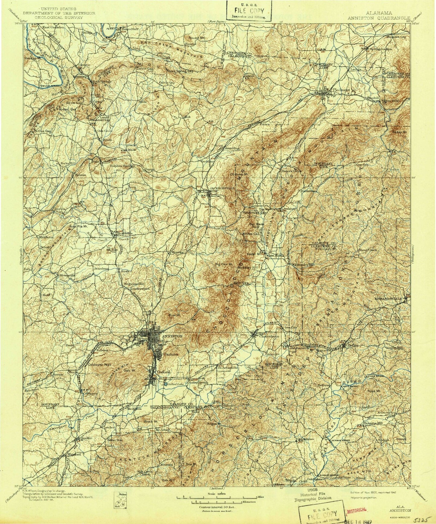
Historical USGS topographic map of Anniston in the state of Alabama. Scale: 1:125000. Print size: 17" x 24"
This map was published in 1900 and is in the following counties: Calhoun, Cherokee, Cleburne, Etowah, Talladega.
The map contains contour lines, roads, rivers, towns, streams, and lakes. Printed on high-quality waterproof paper with UV fade-resistant inks.
Contains the following named places: Aderholts Lake, Alexander Gap, Alexandria Creek, Anniston Beach, Baltzell Mountains, Bells Lake, Bennetts Lake, Big Cove Creek, Blue Mountain, Blue Mountain, Blue Mountain Ridge, Boozers Lake, Brook Mountain, Burns Park, Cable Hill, Caffey Hill, Camp Willett, Camp Zinn, Cemetery Hill, Chums Lake, Cobb City, West End Anniston, Coffee Creek, Coldwater Peak, Colvin Gap, Colwell, Crystal Springs Lake, Darbys Lake, Davis Hill, Dry Creek Mountain, Duke, Egbert Hill, Eulaton, Ewing, Finks Lake, Ford Hill, Gardner Hill, Glencoe, Golden Springs, Goodwin Lake, Hamiltons Lake, Howitzer Hill, Ingram Creek, Iron Mountain, Jerry Hill, Jones Hill, Keysburg, King Hill, Laney, Letchers, Little Cove Creek, Lowrimores Crossroads, Middle Gate, Miller Hill, Nesbitt Lake, Overton Lake, Oxanna, Peck Hill, Pelham Heights, Perry Hill, Phillips Gap, Ramsey Hill, Remount Creek, Reservoir Ridge, Reynolds Hill, Round Mountain, Mount Royal, Ryther Hill, Saks, Samplers Lake, Sherman Heights, Silver Ridge, Skeleton Mountains, South Branch Cane Creek, Sunset Hill, Tarsus, Thompson Lake, Tidmore Bend, Trenci Hill, Twin Mountains, Walker Gap, Weavers Creek, Wellington, West Wellington, Wheeler Hill, Wilson Mountain, Wygant Hill, Zinn Park, Cone Reservoir Dam, Yahou Dam, Yahou Lake, Owens Dam, Lake Contreras, Pelham Range Dam, Doss Lake, Harpers Lake Number One, Finks Dam, Reilly Lake, Reilly Lake Dam, Policemen Lake, Policeman Lake Dam, McCullars Number 1 Dam, McCullars Lake Number 1, McCullars Number 2 Dam, McCullars Lake Number Two, Edwards Lake, Edward Dam, Saxons Lake, Saxon Dam, Coley Lake, Coley Dam, Coley Dam, Kellys Dam, Patterson Lake, Patterson Dam, Donner Dam, Donner Lake, Nunally Dam, Gray Dam, Thrasher Dam, Thrasher Lake, Keyes Dam, Keyes Lake, Bells Dam, Big Oak Dam, Big Oak Lake, Lee Dam, Lees Lake, Lay Dam, Church Lake, Presbyterian Church Dam, Overton Dam, Templeton Dam, Templeton Pond, Harrelson Dam, Harrelson Lake, McBride Lake, McBride Dam, Bonners Lake, Bonner Dam, Bennett Dam, Cobb Quarry, Colvin, Gadsden Raceway, Green Valley Raceway, Reaves, Rock Spring Junction, Smiths Crossroads, Anniston Country Club, Anniston Plaza Shopping Center, Askew Field, Battle Creek, Bethel, Betta-Life, Boozers Lake, Broadwells Mill, Brutonville, Cane Creek, Church Street Plaza Shopping Center, Colvins Gap, Crystal Springs, Davis Gap, Eastwood, Five Points Shopping Center, Four Mile, Germany Springs Park, Golden Springs Shopping Center, Halls Chapel, Hillcrest, Holly Springs, Indian Oaks Country Club, Jacks Shopping Center, Jacksonville City Park, Jacksonville Plaza Shopping Center, Jacksonville Sewage Treatment Plant, Jaycee Park, John Pelham Monument, Lenlock, Lenlock Shopping Center, McClellan Mart Shopping Center, Mechanicsville, Memorial Stadium, Memorial Stadium, Mount Polk, New Liberty, Parkwood, Pelham Park, Pelham Plaza Shopping Center, Post Oak, Prickettville, Rock Pile Mountain, Rock Spring Gap, Saks Shopping Center, Spring Valley, Stoney Brook Golf Course, Tyler Park, Union, Wellborn, West Anniston Park, West Point, Fords Valley, Keeling Island, Pennys Crossroads, Pine Grove, Keeling Bend, Alexandria Valley, Big Pine Hills, Blue Springs, Bobs Creek, Booker T City, Boyd Spring Branch, Burns Valley, Point Calhoun, Chalybeate Mountain, Clarkes Gap, Coker Mountain, Easterwood Branch, Havers Creek, Hurds Gap, Leatherwood Slough, Linders Spring Branch, Maxwell Cove, Nesbitt Hill, Oak Level, Ohatchee Mountains, Possum Trot, Rabes Branch, Ricks Branch, Sulphur Springs Creek, Virgil Creek, Washer Hill, Wayside, Youngblood Gap, Cedar Springs, Kellys Lake, Leatherwood