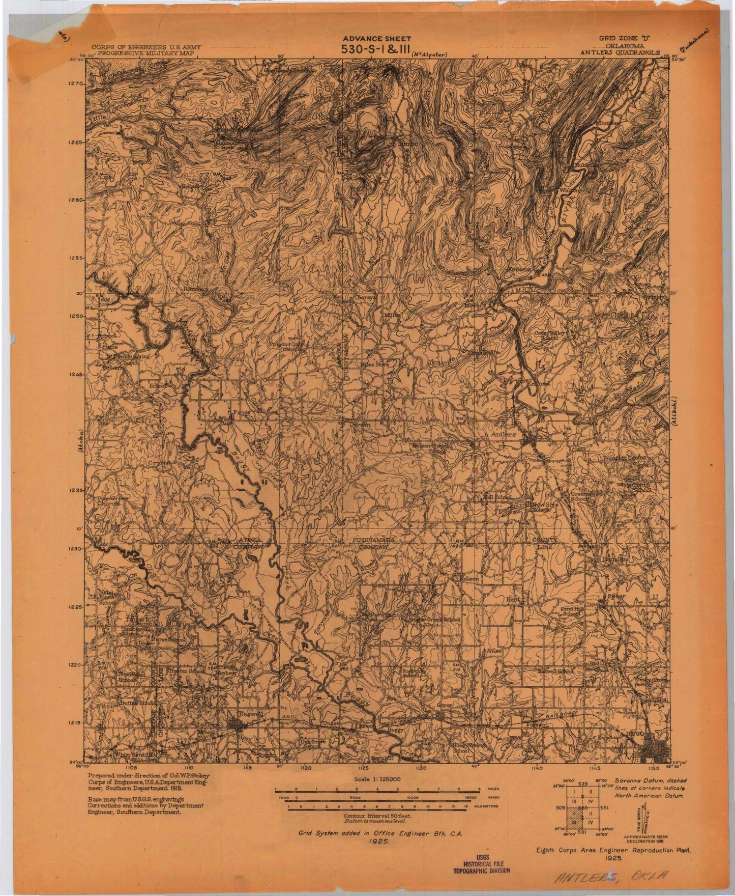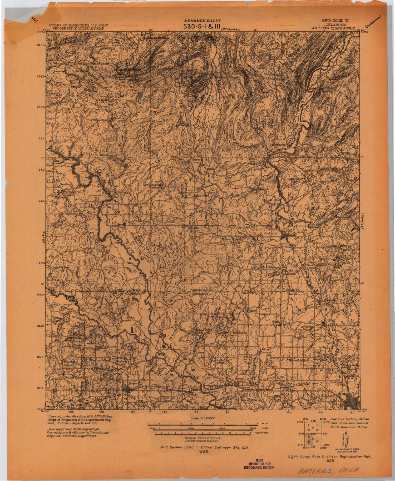
MyTopo
Historic 1925 Antlers Oklahoma 30'x30' Topo Map
Couldn't load pickup availability
Historical USGS topographic map of Antlers in the state of Oklahoma. Scale: 1:125000. Print size: 19" x 24"
This map was published in 1925 and is in the following counties: Atoka, Bryan, Choctaw, Pushmataha.
The map contains contour lines, roads, rivers, towns, streams, and lakes. Printed on high-quality waterproof paper with UV fade-resistant inks.
Contains the following named places: Allen Lake, Ansley Park, Antlers, Atoka Lake, August Creek, Bear Creek, Beaver Creek, Beaverdam Creek, Bee Creek, Bench Lake, Beulah Creek, Big Branch, Big Mountain, Bitter Creek, Blowout Hollow, Blowup Creek, Blue Creek, Boehler Lake, Bog Spring Branch, Boggy Cutoff, Boswell, Box Spring Mountain, Box Springs Mountain, Breadtown Creek, Briar Branch Creek, Brushy Lake, Buck Creek, Buck Creek Mountain, Bugaboo Canyon, Bull Creek, Bull Creek Mountain, Cabin Creek, Caney Creek, Caney Creek, Caroline Creek, Cat Creek, Cat Hollow, Cat Hollow, Cedar Creek, Cedar Creek, Cedar Hollow, Center Point, Charlie Creek, Chickasaw Creek, Clay Branch, Clear Boggy Creek, Clear Creek, Clear Lake, Cobb Lake, Coffee Creek, Colbert Lake, Colby Creek, Cold Springs Creek, Cold Springs Creek, Cole Creek, Crab Tree Branch, Crooked Creek, Crowder Creek, Davenport Creek, Delaware Creek, Dobbins Lake, Double Springs Creek, Dry Lake, Dry Pointer Creek, Dumpling Creek, East Branch August Creek, East Sandy Creek, Edmond Slough, Elm Creek, Farris, Flat Top Mountain, Fobb Creek, Frederick Creek, Grassy Branch, Grassy Creek, Grassy Hollow, Grassy Hollow, Grassy Lake, Greasy Creek, Hackett Creek, Haggerman Creek, Hampton Creek, Harrington Branch, Hasell Lake, Hiawana Creek, Hiawana Prairie, Hickory Flat, Hogpen Lake, Holly Branch, Hopena Lake, Horsehead Creek, Horsehead Creek, Horsehead Mountain, Hugo, Impson Church, Impson Valley, Jacob Hollow, Johns Creek, Johns Valley, Judge Cox Branch, Kennedy Hollow, Kimbrough Creek, Kosoma, Lamey Slash, Lane, Lily Pond Creek, Little Bugaboo Creek, Little Caney Creek, Little Cedar Creek, Little Davenport Creek, Little Kimbrough Creek, Little Mountain, Little Tenmile Creek, Little Wildhorse Creek, Logan Hollow, Long Bell Creek, Long Mountain, Lost Mountain, Louie Lake, Maddox Creek, Marble Creek, Mayhew Creek, McGee Creek, McGee Valley, Medicine Branch, Mill Creek, Monkeywrench Creek, Mosley Lake, Mud Creek, Newkirk Lake, North Branch Double Springs Creek, North Branch Elm Creek, North Fork Long Creek, Otter Hollow, Panther Creek, Panther Creek, Parker Mountain, Patterson Creek, Peacock Hollow, Pecan Branch, Pine Creek, Pine Creek, Pine Hollow, Pole Creek, Potapo Creek, Potubbi Creek, Prairie Hollow, Racetrack Prairie, Randolph Creek, Rard Branch, Ray Creek, Ray Hollow, Razorback Mountain, Robison Creek, Rock Creek, Rocky Branch, Rodney Mountain, Ross Branch, Rough Hollow, Rough Hollow, Salt Lake, Sand Branch, Sand Branch, Sandy Creek, Sandy Creek, Shawnee Creek, Shorty Creek, Silver Creek, Soper, South Branch Double Springs Creek, South Branch Elm Creek, Spring Branch, Spring Branch, Spring Branch, Stink Branch, Stovepipe Creek, Sugar Creek, Sugar Creek, Sugarloaf Hill, Sunshine Hollow, Tanyard Creek, Taylor Creek, Tenmile Creek, Tenmile Lake, Texas Hole, Timber Hill, Unger, West Sandy Creek, Whisky Creek, Whisky Hollow, Whisky Hollow, White Rock Mountain, Wildcat Canyon, Wildcat Creek, Wildcat Hollow, Wildcat Trail, Wildhorse Creek, Wilson Creek, Wilson Hollow, Yerby Branch, Big Rocks, Boehler, Cade, Crystal, Darwin, Dela, Dunbar, Ethel, Eubanks, Forney, Fugate, Greenwood, Hamden, Jasper, Jumbo, Kellond, Kent, Lone Pine, Mayhew, Miller, Moyers, Negro Bend, Nelson, Old Farris, Payton Crossing, Sand Bluff, Speer, Sunkist, Wadena, Choctaw County, Antlers Waterworks, Lake Newkirk Dam, Krebs Lake Dam, Krebs Lake, Oknoname 023002 Dam, Oknoname 023002 Reservoir