MyTopo
Historic 1891 Ashland Alabama 30'x30' Topo Map
Couldn't load pickup availability
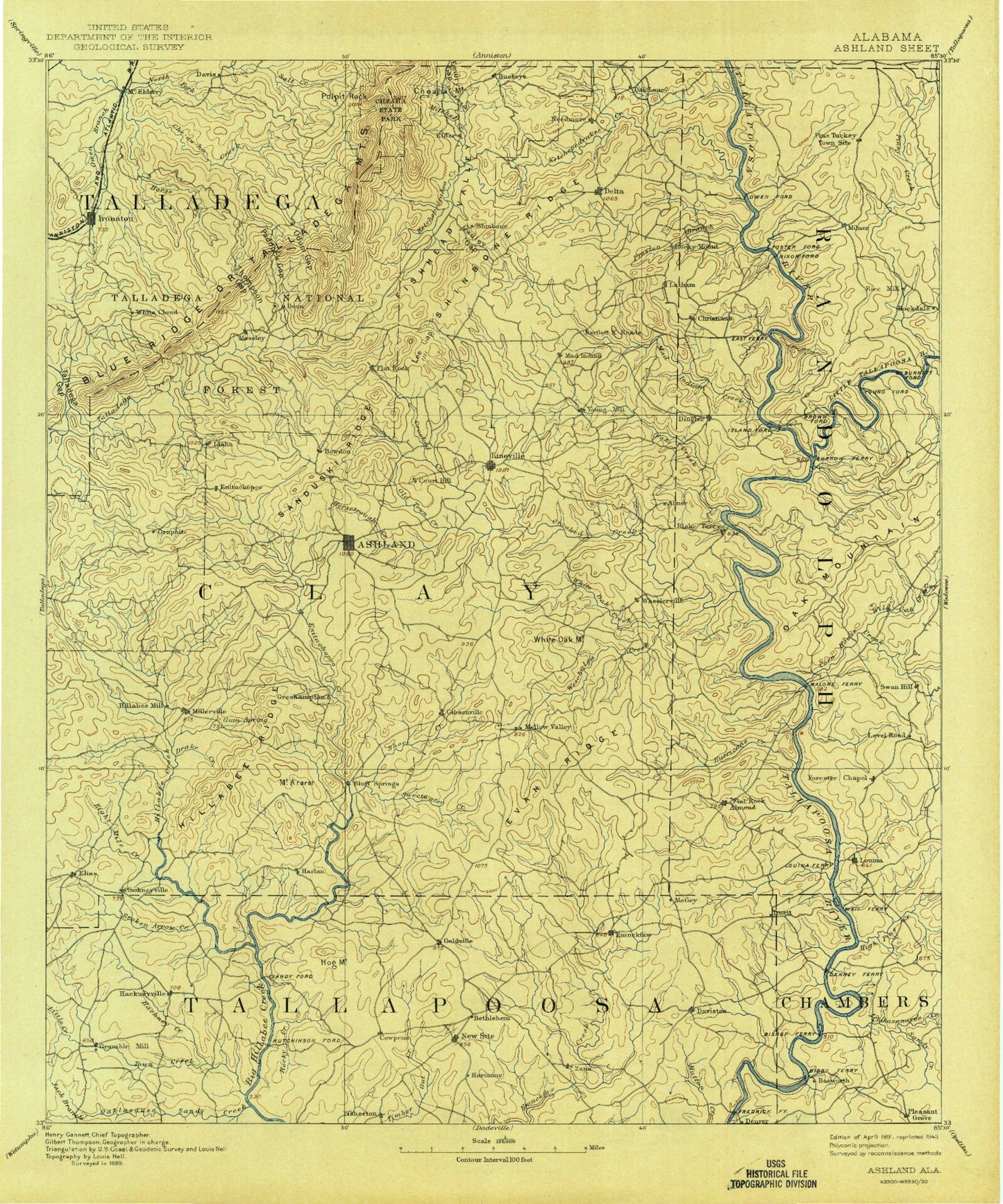
Historical USGS topographic map of Ashland in the state of Alabama. Scale: 1:125000. Print size: 17" x 24"
This map was published in 1891 and is in the following counties: Chambers, Clay, Cleburne, Randolph, Talladega, Tallapoosa.
The map contains contour lines, roads, rivers, towns, streams, and lakes. Printed on high-quality waterproof paper with UV fade-resistant inks.
Contains the following named places: Buck Branch, Abanda, Allen Branch, Andanley Branch, Barfield, Barnes Memorial Park, Birdsong Creek, Bishop Mountain, Brewer Creek, Broken Arrow Creek, Buck Branch, Buck Mountain, Burkhalter Branch, Carlisle Branch, Carr Creek, Caty Creek, Cockrell Mountain, Concord Lake, Corinth, Cotney Lot Creek, Cowpens, Daviston, Dewberry Branch, Dewberry Branch, Dinner Creek, Dipping Vat Creek, Fixico Creek, Flat Rock, Forester Chapel, Foster Crossroad, Gin Pond Creek, Ginhouse Branch, Grapevine Creek, Greasy Creek, Hackney Creek, Hackneyville, Hall Creek, Harkins Crossroads, High Pine Creek, Hillabeehago Branch, Hodge Island, Hodges Creek, Hodnett Mill Creek, Hog Mountain, Holdridge Branch, Hunter Branch, Hunter Branch, Hunter Creek, Hurricane Branch, Hutton Creek, Ingram Branch, Jacks Branch, Jeter Branch, Jett Mountain, Jones Branch, Jones Creek, Jones Vane Creek, Kennedy Branch, Lane Branch, Laney Creek, Little Creek, Little Emuckfaw Creek, Little Mississippi Creek, Little Pineywood Creek, Loombeam Creek, Mattox Branch, Micaville, Milam Creek, Miles Branch, Mill Branch, Moore Branch, Moore Creek, Muleshoe Bend, Oak Mountain, Oaktasasi Creek, Parker Branch, Perryville, Plunkett Mountain, Poe Branch, Price Branch, Price Island, Rocky Branch, Rocky Creek, Rotton Creek, Sandy Creek, Sandy Creek, Shool Creek, Street Mountain, Swan Hill, Sweetwater Creek, Tanyard Branch, Triplett Creek, Turkeypen Creek, Turpentine Still Branch, Union Hill, Wadley, Wedowee Creek, Wesobulga Creek, White Oak Creek, Wildcat Creek, Wolfpen Creek, Monaghan Dam, Monaghan Lake, Whatley Dam, Whatley Pond, Osborne Dam, Patterson Dam, Patterson Lake, Clegg and Pearson Dam, Clegg and Pearson Lake, Concord Dam, College Lake Dam, College Lake, Frost Lake, Frost Dam, Transco Dam, Knight Dam, Blair Number 1 Dam, Blair Number 2 Dam, Crooked Creek Watershed Dam Number 16, Carter Lake, Lineville Club Lake, Lineville Dam, Boyd Lake, Boyd Dam, Brady Lake, Brady Lake Dam, Grays Lake, Gray Dam, Tallapoosa River Hunting Club, Sparkling Springs, Denny Lake, Hog Mountain Goldmine, Evan Ridge, White Oak Mountain, Big Hunting Club, Blake, Buckhannon Creek, Cedron, Concord, Folsom, Liberty, Piedmont Upland, Cornhouse Creek, Manning Placer Mine, Mitchell Prospect Number One, Amason Prospect, Farrar-Wallace Prospect, Walker Prospect, Knights Mill Prospect, Dawkins Prospect, Carter Prospect, Corinth, Landowners Hunting Club, Section Eighteen Prospect, Empire Mine, Atlas Mine, Hood-Graves Mine, Benjamin Prospect, Grizzel Prospect, Cockrell Placer Mine, Shiloh, Smith Mine, Lineville Mine, Peerless Mine, Crystalline Flake Mine, Clay County Country Club, Alabama Gold and Mica Mine, Monitor Mine, Barrett Mine, American Mine, Southern Mine, Sewell-Caldwell Prospect, Eley Mine, Haraldson Mine, McLellan Mine, Little Samson Prospect, Idaho Mine, Crucible Prospect, Hobbs Prospect, Horns Peak Mine, Acme Mine, California Prospect, Ashland Mine, Griessemer Mine, Southern Star Mine, May Brothers Mine, Pocahontas Mine, Enterprise Mine, Whatley Mine, Axton-Noe Mine, Alabama Number Two Mine, Stringfellow Prospect, Allen Mine, Jefferson Mine, Crucible Mine, Norway Mine, Smith Prospect, Dunlin Mine, Dempsey Prospect, Dempsey Mine, Yates Mine, Chikasanoxee Creek, Osborn Creek, Rock Pile Creek, Tanyard Branch, Town Creek, Blair Lake Number 2, Denny, Beaverdam Creek, Cedar Creek, Hurricane Creek, Level Road, Little Tallapoosa River, Mill Creek, New Site, No Business Creek, Almond, Berwick, Bluff Springs, Bosworth, Cleveland Crossroads, Cooley Crossroads, Corinth, Dingler, Frog Eye, Gibsonville, Goldville, Louina, Malone, Mellow Valley, Milner, Motley, Ofelia, Pinkneyville, Pine Tuckey