MyTopo
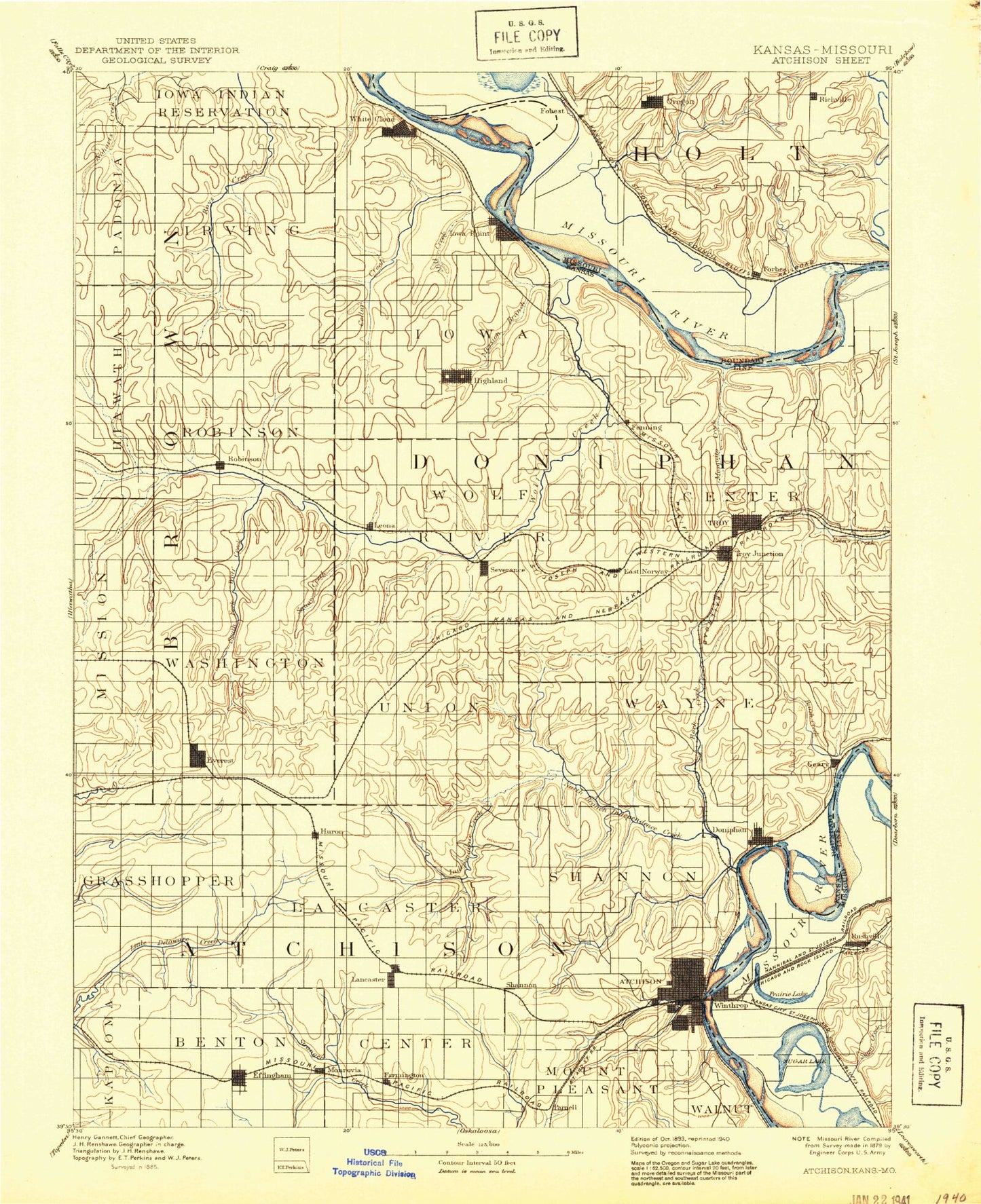
Historic 1893 Atchison Kansas 30'x30' Topo Map
Couldn't load pickup availability
Historical USGS topographic map of Atchisonin the states of Kansas, Nebraska, Missouri. Scale: 1:125000. Print size: 17" x 24"
This map was published in 1893 and is in the following counties: Andrew, Atchison, Brown, Buchanan, Doniphan, Holt, Platte, Richardson.
The map contains contour lines, roads, rivers, towns, streams, and lakes. Printed on high-quality waterproof paper with UV fade-resistant inks.
Contains the following named places: Township of Hiawatha, Township of Irving, Old Channel Big Nemaha River, Mill Creek, Cedar Creek, Fox Creek, Spring Creek, White Cloud, Nolands Creek, Township of Iowa, Iowa Point, Lookout Mountain, Wolf River, Township of Center, Mission Creek, North Fork Wolf River, Township of Robinson, Township of Washington, South Fork Wolf River, Buttermilk Creek, Middle Fork Wolf River, Robinson, Brown County State Park, Township of Wolf River, Severance, Squaw Creek, Halling Creek, Leona, Highland, Rittenhouse Branch, Township of Independence, Nelson Creek, Springs Branch, Cold Ryan Branch, Rock Creek, Moray, Kenney Creek, Pennell Creek, Coon Creek, Fanning, Sparks, Striker Branch, Township of Marion, Brush Creek, Cottonwood Creek, Blair, Troy, Mosquito Creek, Township of Grasshopper, Township of Lancaster, Atchison County Park, Kennekuk, Everest, Hazel Creek, Independence Creek, Huron, Purcell, Township of Union, North Branch Independence Creek, Atchison County State Park, Jordan Creek, Bendena, Township of Shannon, Doniphan, Township of Wayne, Figge Lake, Effingham, Little Stranger Creek, North Fork Stranger Creek, Lancaster, Farmington, Monrovia, Whiskey Creek, White Clay Creek, Deer Creek, Shannon, Amelia Earhart Stadium, Reisner Park, Brewery Creek, Atchison, Lang Hollow, Jackson Park, Brown State Fishing Lake and Wildlife Area, Atchison State Fishing Lake and Widlife Area, Iowa Reservation, Brown County State Lake, Brown County State Lake Dam, Clear Creek Lake, Atchison County Dam, Glacier Uplands, Duncan Creek, Good Intent, Charlie Creek, West Atchison Mall, Atchison Mall, Helena, Lost Shirt Creek, Brenner, Denton, Parnell, Atchison County, Doniphan County, City of Atchison, City of Highland, City of Huron, City of Denton, City of Effingham, City of Everest, City of Lancaster, City of Leona, City of Robinson, City of Severance, City of Troy, City of White Cloud, Huron Wastewater Treatment Plant, Lancaster Sewage Treatment Plant, Robinson Wastewater Treatment Plant, Effingham Sewer Treatment Plant, Atchison Water Treatment Facility, Everest Sewer Treatment Plant, Troy Wastewater Treatment Plant Peters Creek, Highland Sewer Treatment Plant, Shannon Industrial Park, Denton Wastewater Plant, Severance Wastewater Plant, Troy Wastewater Treatment Plant Mosquito Creek, Lovelady Mobile Home Park, Bellevue Country Club, Pineview Country Club, Atchison County Fairgrounds, Doniphan County Fairgrounds, Agricultural Partners Co - Operative Grain Elevator Number 2, Agricultural Partners Co - Operative Grain Elevator Number 7, Blair Grain Elevator, Jackson Farmers Grain Elevator Number 3, Jackson Farmers Grain Elevator Number 4, Meng Farms, Klinefelter Creek, Old Channel Big Nemaha River, Iowa Reservation, Atchinson Bend, Barrett Hollow, Davis Branch, Doniphan Bend, Dyer Branch, Easter Creek, Forbes, Forbes Creek, Forest City, Goose Creek, Hickory Creek, Hicks Hollow, Horseshoe Slough, Howley Branch, Lewis and Clark Village, Lewis and Clark Lake, Lewis and Clark State Park, Lincoln Creek, Little Bean Lake, Fivemile Lane, Lost Creek, McQueen Bend, McWilliams Creek, Meade Creek, Mill Creek, Mud Lake, Pullen Branch, Rock Creek, Schlotz Branch, Short Creek, Sugar Creek, Thorp Branch, Welty Park, Whales Creek, Oregon, Rushville, Winthrop, Little Bean Marsh State Natural History Area, Curzon, Sugar Lake, Armour, Richville, Sugar Lake, Frank Milne Dam, Milne Lake, Dead Mans Hole Dam, Dead Mans Hole, Township of Lake, Township of Rush, Township of Forbes, Township of Forest, Township of Lewis, Riverbreaks Conservation Area, City of Forest City, City of Oregon, Town of Lewis and Clark Village, Town of Rushville, Rushville Bend