MyTopo
Historic 1914 Avery Idaho 30'x30' Topo Map
Couldn't load pickup availability
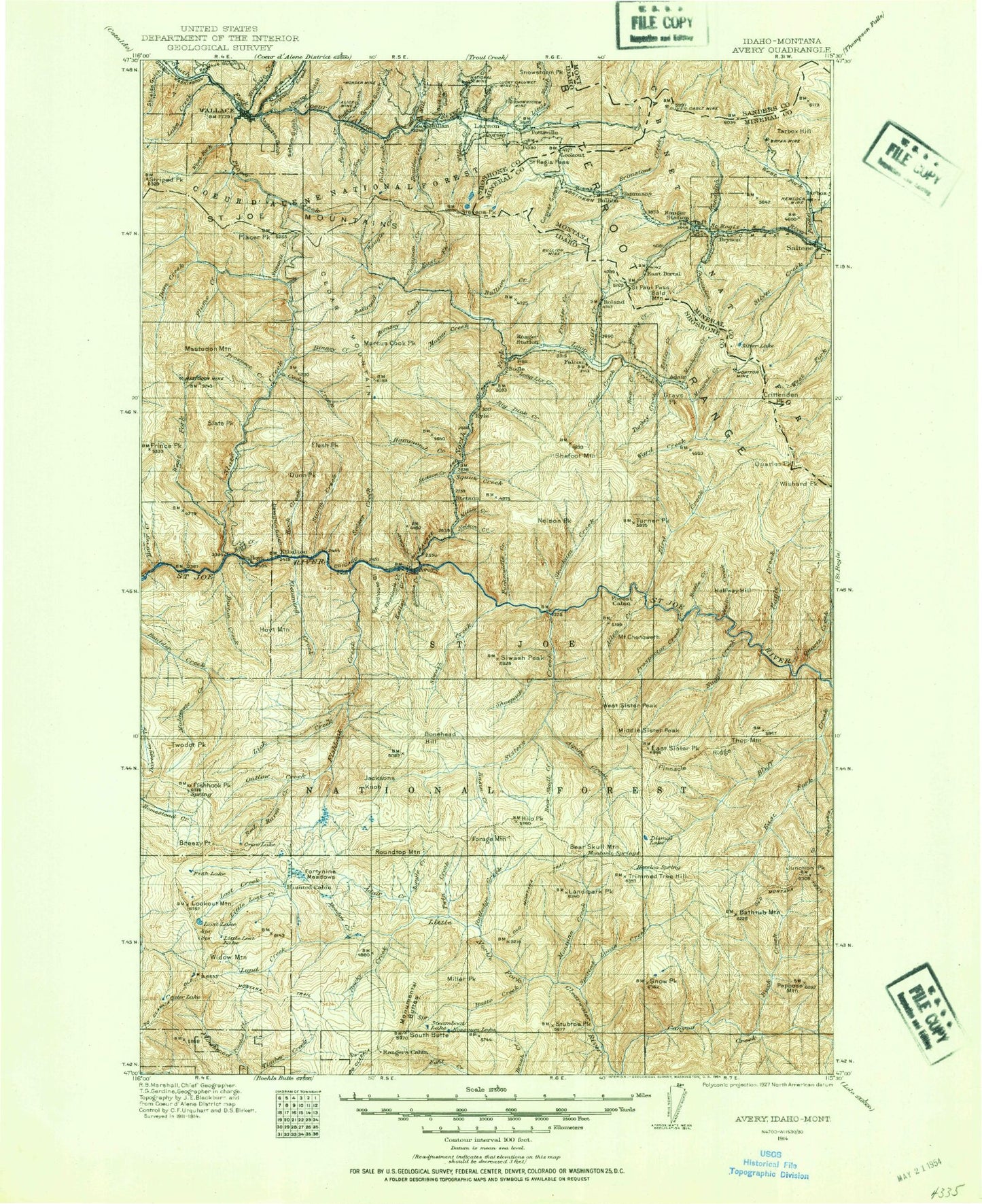
Historical USGS topographic map of Avery in the state of Idaho. Scale: 1:125000. Print size: 17" x 24"
This map was published in 1914 and is in the following counties: Mineral, Sanders, Shoshone.
The map contains contour lines, roads, rivers, towns, streams, and lakes. Printed on high-quality waterproof paper with UV fade-resistant inks.
Contains the following named places: Bald Mountain, Bullion Mine, Bullion Pass, Daisy Gulch, Galena Mine, Hardpan Point, Klondike Gulch, Lookout Pass, Lucky Calumet Mine, Mullan Pass, O'Brien Gulch, Roland Point, Saint Paul Pass Tunnel, Shoshone Park, Snowstorm Peak, Stubtoe Peak, Wonderful Creek, Wonderful Mine, Little North Fork South Fork Coeur d'Alene River, S Bridge, Adair Creek, Adams Creek, Alice Mine, Allen Creek, Allen Creek, Allen Ridge, Ally Gulch, Ally Point, Alpine Creek, Argentine Creek, Arid Peak, Avery Creek, Avery Hill, Bad Luck Creek, Bad Tom Mountain, Badger Creek, Barren Hill, Bathtub Creek, Bathtub Meadows, Bathtub Mountain, Bear Creek, Bear Skull Creek, Benchmark Hill, Bennett Creek, Bennett Point, Bernier Creek, Bernier Point, Big Dick Creek, Big Dick Point, Binney Creek, Bird Creek, Birthday Creek, Bitterroot Mountains, Blackjack Creek, Blue Grouse Creek, Bluebird Creek, Bluebird Point, Bluff Divide, Bluff Point, Bootleg Creek, Bottle Creek, Boulder Divide, Brebner Flat, Breezy Point, Breezy Saddle, Brush Hill, Brushy Creek, Buck Creek, Bullet Creek, Bullion Creek, Burton Creek, Butte Creek, Cache Creek, Cairn Creek, Cairn Creek, Canyon Creek, Canyon Creek, Canyon Peak, Carbonate Hill Mine, Caribou Creek, Cedar Creek, Cedar Lake, Cedar Mountain, Cedar Mountain, Cedar Mountain Trail, Champion Creek, Champion Point, Mount Chenoweth, Chute Creek, Clear Creek, Cliff Creek, Coddington Creek, Coeur d'Alene Saint Joe Divide, Copper King Mine, Corvus Creek, Cougar Creek, Coyote Creek, Craddock Creek, Cranky Gulch, Crow Lake, Culdesac Creek, Daisy Gulch, Daly Gulch, Dam Creek, Daveggio Meadows, Debbitt Basin, Delaney Creek, Dennis Knob, Dexter Gulch, Dismal Lake, Dominion Peak, Dry Gulch, Dry Gulch, Dunce Creek, Dunn Peak, Durham Creek, Eagle Creek, East Butte, East Fork Bluff Creek, East Fork Brush Creek, East Fork Fishhook Creek, East Fork Twin Creek, East Fork Willow Creek, Point Eightyone, Elbow Gulch, Elevator Creek, Elmo Mine, Experimental Draw, Fish Lake, Fisher Creek, Fishhook Creek, Fishhook Peak, Flash Peak, Flatiron Knobs, Flora Gulch, Flume Creek, Foolhen Creek, Foolhen Mountain, Forage Creek, Forage Mountain, Fortune Meadows, Fortune Point, Fortynine Gulch, Fortynine Meadows, Franklin Mine, Frazier Creek, Fritz Creek, Fume Creek, Fuzzy Creek, Fuzzy Peak, Gentle Annie Gulch, Gibson Point, Glen Creek, Gold Hill, Gold Hunter Mine, Grays Peak, Gypo Creek, Halfway Hill, Hammond Creek, Hardpan Creek, Harvey Creek, Hemlock Spring Creek, Point Henry, Hilo Creek, Hilo Peak, Hoodoo Ridge, Hord Gulch, Horn Gulch, Horseshoe Creek, Hoyt Creek, Hoyt Mountain, Italian Creek, Jitney Gulch, Junction Creek, Jungle Creek, Kelley Creek, Kelly Pinnacle, Kyle Creek, Lake Creek, Landmark Peak, Lick Creek, Lightning Creek, Lightning Ridge, Line Gulch, Little Lost Lake, Little North Fork Campground, Lone Lake, Long Liz Creek, Long Liz Point, Lookout Mountain, Loop Creek, Lost Lake, Lost Lake, Lost Lake Creek, Lower Shoepack Point, Lower Stevens Lake, Lucky Friday Mine, Lucky Swede Gulch, Lumberjack Creek, Lund Creek, Mack Gulch, Malamute Creek, Malamute Point, Malin Creek, Malin Point, Mammouth Springs Campground, Manhattan Creek, Marion Creek, Mastodon Mine, Mastodon Mountain, Meadow Creek, Middle Creek, Miller Creek, Mineral Creek, Mink Creek, Mirror Creek, Mirror Peak, Montana Creek, Montana Ridge, Monumental Buttes, Moon Pass, Moon Peak, Morgan Creek, Morning Mine, Morning Mine 4, Morning Mine 5, Moses Butte, Moss Creek, Motor Creek, Mowich Creek, Mozier Creek, Mozier Peak, Mullan, Murray Creek, N P Hill, National Mine