MyTopo
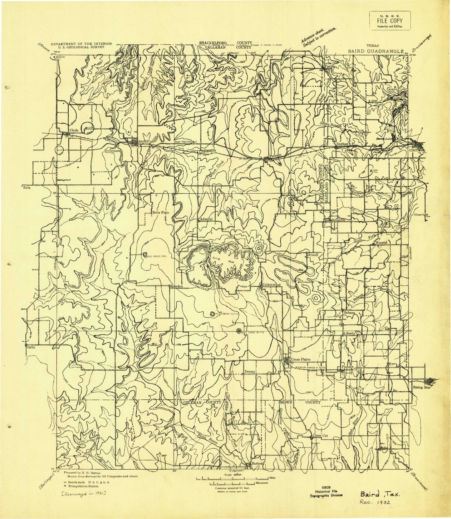
Historic 1932 Baird Texas 30'x30' Topo Map
Couldn't load pickup availability
Historical USGS topographic map of Baird in the state of Texas. Scale: 1:125000. Print size: 20" x 24"
This map was published in 1932 and is in the following counties: Brown, Callahan, Coleman, Eastland.
The map contains contour lines, roads, rivers, towns, streams, and lakes. Printed on high-quality waterproof paper with UV fade-resistant inks.
Contains the following named places: Bear Branch, Bee Branch, Bernie Lake, Bluff Branch, Brushy Creek, Buffalo Branch, Bull Pasture Windmill, Burkett Oil Field, Burnt Branch, Lake Cisco, Clear Creek, Condemn Branch, Cooper Creek, Cottonwood Creek, Cottonwood Creek, Coyote Peak, Crooked Creek, Cross Cut, Cross Plains, Cross Plains Oil Field, Club Hollow, Dinner Branch, Dinner Branch, Dooley Creek, East Caddo Peak, East Fork Brushy Creek, Four-Hundred Acre Windmill, Goble Windmill, Haynes Windmill, Herd Branch, High Windmill, Lick Branch, Little Pecan Bayou, Live Oak Branch, Live Oak Branch, Live Oak Creek, Lovelady Creek, Mesquite Branch, Mexia Creek, Mexican Hat Hill, North Prong Pecan Bayou, Paint Creek, Phil-Pe-Co Lake, Putnam, Richardson Windmill, Rocky Branch, Rough Creek, Sand Branch, Scott Oil Field, Sheep Creek, Sneed Windmill, South Prong Pecan Bayou, Spring Gap, Trap Windmill, West Caddo Peak, West Fork Brushy Creek, West Prong Burnt Branch, Wolf Hollow, Baird Lake, Cross Cut Oil Field, Baird, Bell Park, Clyde, Kaiser Creek, Salt Branch, T P Lake, Wilkerson Branch, Dothan, Admiral, Atwell, Belle Plain, Cottonwood, Jayell, Mitchell, Nimrod, Pioneer, Rowden, Sabanno, Scranton, Webbville, Williams, Callahan County, Lakewood Reservoir Dam, Dothan Water Station Levee, Dothan Water Station Lake, Retention Dam, Battle Creek Channel Lake, Soil Conservation Service Site 19 Dam, Soil Conservation Service Site 19 Reservoir, Soil Conservation Service Site 20 Dam, Soil Conservation Service Site 20 Reservoir, Soil Conservation Service Site 24 Dam, Soil Conservation Service Site 24 Reservoir, Knox Dam Number 1, Knox Lake Number 1, Knox Dam Number 2, Knox Lake Number 2, Knox Dam Number 3, Knox Lake Number 3, Coleman Dam, Soil Conservation Service Site 8 Dam, Soil Conservation Service Site 8 Reservoir, Soil Conservation Service Site 9 Dam, Soil Conservation Service Site 10 Dam, Soil Conservation Service Site 10 Reservoir, Soil Conservation Service Site 22 Dam, Soil Conservation Service Site 22 Reservoir, Burkett Lake, Soil Conservation Service Site 34 Dam, Soil Conservation Service Site 34 Reservoir, Soil Conservation Service Site 12 Dam, Soil Conservation Service Site 12 Reservoir, Soil Conservation Service Site 11a Dam, Soil Conservation Service Site 11a Reservoir, Soil Conservation Service Site 26 Dam, Soil Conservation Service Site 26 Reservoir, Soil Conservation Service Site 10 Dam, Soil Conservation Service Site 10 Reservoir, Soil Conservation Service Site 22 Dam, Soil Conservation Service Site 22 Reservoir, McDonough Lake Dam, McDonough Lake, Soil Conservation Service Site 8 Dam, Soil Conservation Service Site 8 Reservoir, Soil Conservation Service Site 1b Dam, Soil Conservation Service Site 1b Reservoir, Soil Conservation Service Site 2 Dam, Soil Conservation Service Site 2 Reservoir, Soil Conservation Service Site 4 Dam, Soil Conservation Service Site 4 Reservoir, Soil Conservation Service Site 6 Dam, Soil Conservation Service Site 6 Reservoir, Soil Conservation Service Site 3 Dam, Soil Conservation Service Site 3 Reservoir, Soil Conservation Service Site 7 Dam, Soil Conservation Service Site 7 Reservoir, Soil Conservation Service Site Number 9 Dam, Soil Conservation Service Site Number 9 Reservoir, Soil Conservation Service Site 5 Dam, Soil Conservation Service Site 5 Reservoir, Soil Conservation Service Site 21 Dam, Soil Conservation Service Site 21 Reservoir, Soil Conservation Service Site 23 Dam, Soil Conservation Service Site 23 Reservoir, Soil Conservation Service Site 12 Dam, Soil Conservation Service Site 12 Reservoir, Soil Conservation Service Site 10 Dam, Soil Conservation Service Site 10 Reservoir, Soil Conservation Service Site 1a Dam, Soil Conservation Service Site 1a Reservoir, Soil Conservation Service Site 18a Dam, Soil Conservation Service Site 18a Reservoir, Hall Lake Dam, Hall Lake, Windham Lake Dam, Windham Lake, Soil Conservation Service Site 7 Dam, Soil Conservation Service Site 7 Reservoir, Soil Conservation Service Site 9 Dam, Soil Conservation Service Site 9 Reservoir, Soil Conservation Service Site 6 Dam, Soil Conservation Service Site 6 Reservoir, Mexia Dam, Baird Lake, Baird Railroad Lake Dam, Baird Railroad Lake, Putnam Dam, Putnam Lake, La Reata Dam, La Reata Lake, Cooper Lake Dam, Cooper Lake, Kendall Lake Dam, Kendall Lake, Latimer Lake Dam, Latimer Lake, Smith Lake Dam, Smith Lake, Hatchett Lake Dam, Hatchett Lake, Freeland Lake Dam, Freeland Lake, Texas No Name Number 27 Dam, Texas No Name Number 28 Dam, Texas No Name Number 29 Dam, Texas No Name Number 30 Dam, Baird Division, Cisco Division, Cross Plains Division, The Bears Den Stadium, Pueblo, City of Baird, Town of Cross Plains, Town of Putnam, Baird Quarry, Higgins Quarry