MyTopo
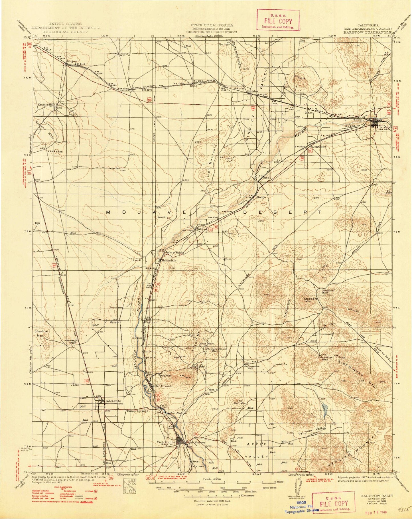
Historic 1934 Barstow California 30'x30' Topo Map
Couldn't load pickup availability
Historical USGS topographic map of Barstow in the state of California. Scale: 1:125000. Print size: 17" x 24"
This map was published in 1934 and is in the following counties: San Bernardino.
The map contains contour lines, roads, rivers, towns, streams, and lakes. Printed on high-quality waterproof paper with UV fade-resistant inks.
Contains the following named places: Altuda Mine, Apex Mine, Apple Valley, Astley Ranch, Barstow Heights Park, Bell Mountain, Bell Mountain, Bell Mountain Wash, Bobcat Canyon, Branch Mine, Brisbane Valley, Buckthorn Wash, Burkhardt Lake, Catholic Hill, Comet Mine, Dana Park, Dent Mine, Desert Knolls Wash, Embody Mine, Fairview Mountain, Fairview Valley, Farly Mine, Foglesong Park, Mount General, Helendale, Hinkley, Hodge, Iron Mountain, Jasper Park, Jessie Saddle, Johnstons Corner, Klondike Mine, Lenwood Park, Lillian Park, Lower Narrows, Lower Slough, Lynx Cat Mountain, Mountain View, North Lake, Oro Grande, Oro Grande Canyon, Oro Grande Mine, Oro Grande Wash, Pedry Mine, Piercy Quarry, Point of Rocks, Quartzite Mountain, Red Hill, Red Raven Mine, Red Top Mine, Shay Quarry, Sidewinder Mine, Sidewinder Mountain, Sidewinder Valley, Silver Mountain, Stoddard Mountain, Stoddard Ridge, Stoddard Valley, Turtle Mountain, Turtle Valley, Twelve Gauge Lake, Upper Narrows, Waterman Hills, Waterman Mine, Wild Wash, Shadow Hills, Bryman, Leon, Hinkley Valley, Fremont Wash, Granite Mountains, Barstow, Victorville, Horseshoe Lake, Airway Beacon 8, Apple Valley Yacht Club, Green Tree Country Club, Victor Valley Country Club, Victorville City Dump, Adelanto, Apple Valley, B Hill, Black Mountain, Frost, Grandview, Hutt, Jimgrey, La Delta, Lenwood, Macks Peak, Mojave Heights, Sparkhule Mountain, Sugarloaf, Wild Crossing, Buckthorn Canyon, Hinkley Valley Grange, H Street Soccer Fields, Irwin Estates, North Barstow, Skyline North, Waterman Park, Barstow Heights, Factory Merchants at Barstow Shopping Center, Silver Lakes Country Club, Silver Lake Farm, Stringham Park, Sun Valley Country Club, Adelanto Park, Bartlett Square Shopping Center, Daha Park, Howard Loy Park, Maverick Baseball Stadium, North Lake, Richardson Park, South Adelanto, South Lake, Sunrise Motorcycle Park, Western States Mine, Westside Park, Apple Valley Gun Club, Apple Valley Ridge, Avalon Park, Bellevue Heights, Center Street Park, Corwin Road Park, Desert Knolls, Desert Valley Shopping Center, Eldridge Ridge, Eva Dell Park, Fairview Dry Lake, Forrest Park, Golden Mesa, Grady Trammel Park, Greentree East, Hook Park, Kemper Campbell Ranch, Pebble Beach Park, Pelican Lake, Rockview Park, San Bernardino County Fairgrounds, The Village, Thunderbird Ranches, Valley Center Shopping Center, Valley High North, Victor Plaza Shopping Center, Victor Valley Shopping Center, Victorville Municipal Golf Course, Village Park, West Wind Golf Course, Apple Pond, Apple Valley Dry Lake, Apple Valley Fire Center, Apple Valley Grange, Bass Hill, Desert Knolls Manor, Highway 18 Park, Little Bell Mountain, Pioneer Mountain, Virginia Park, City of Adelanto, City of Barstow, City of Victorville, Town of Apple Valley, Victor Valley Wastewater Reclamation Authority, Victorville-Hesperia Division, Silver Lakes, Best Rock Quarry