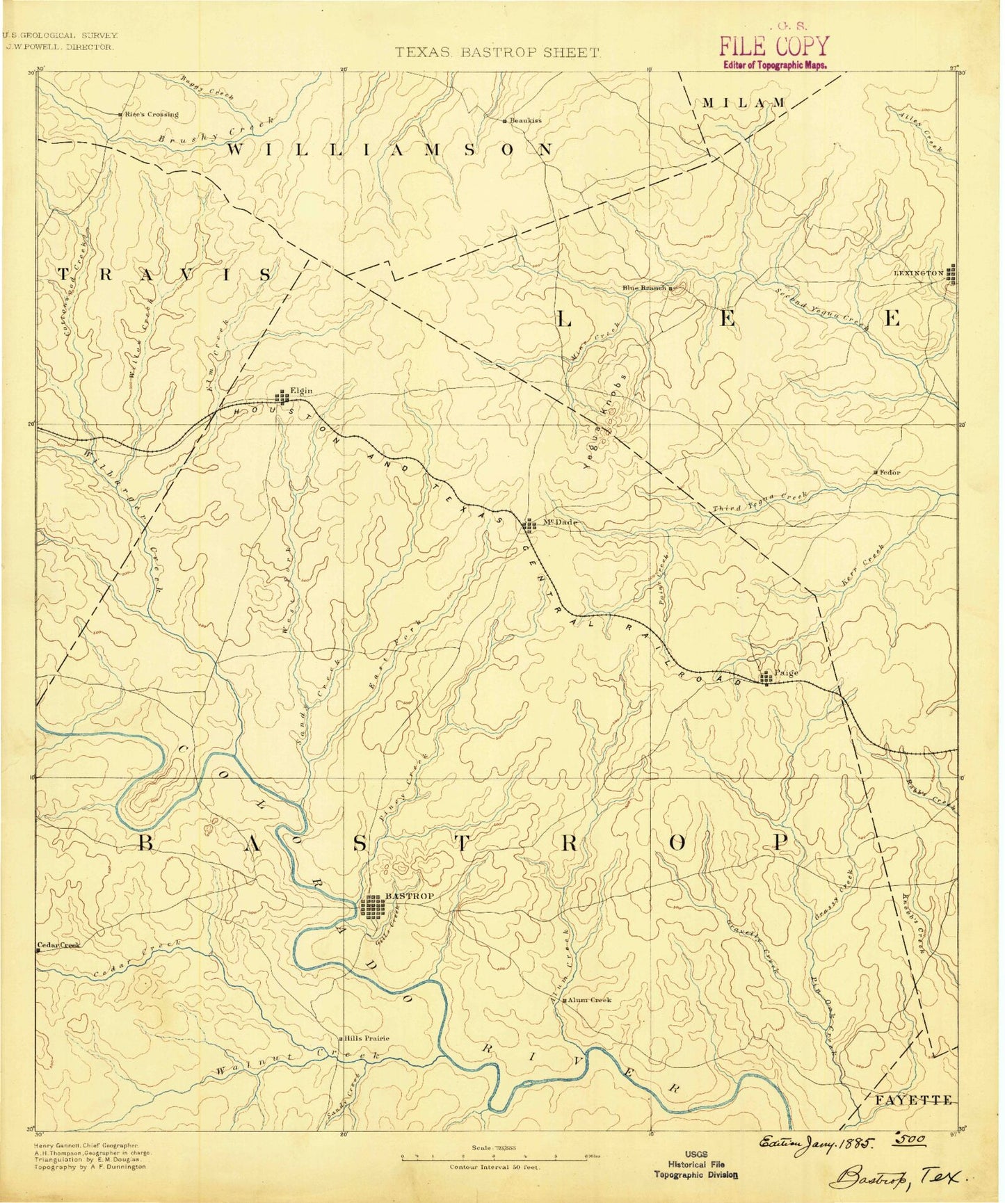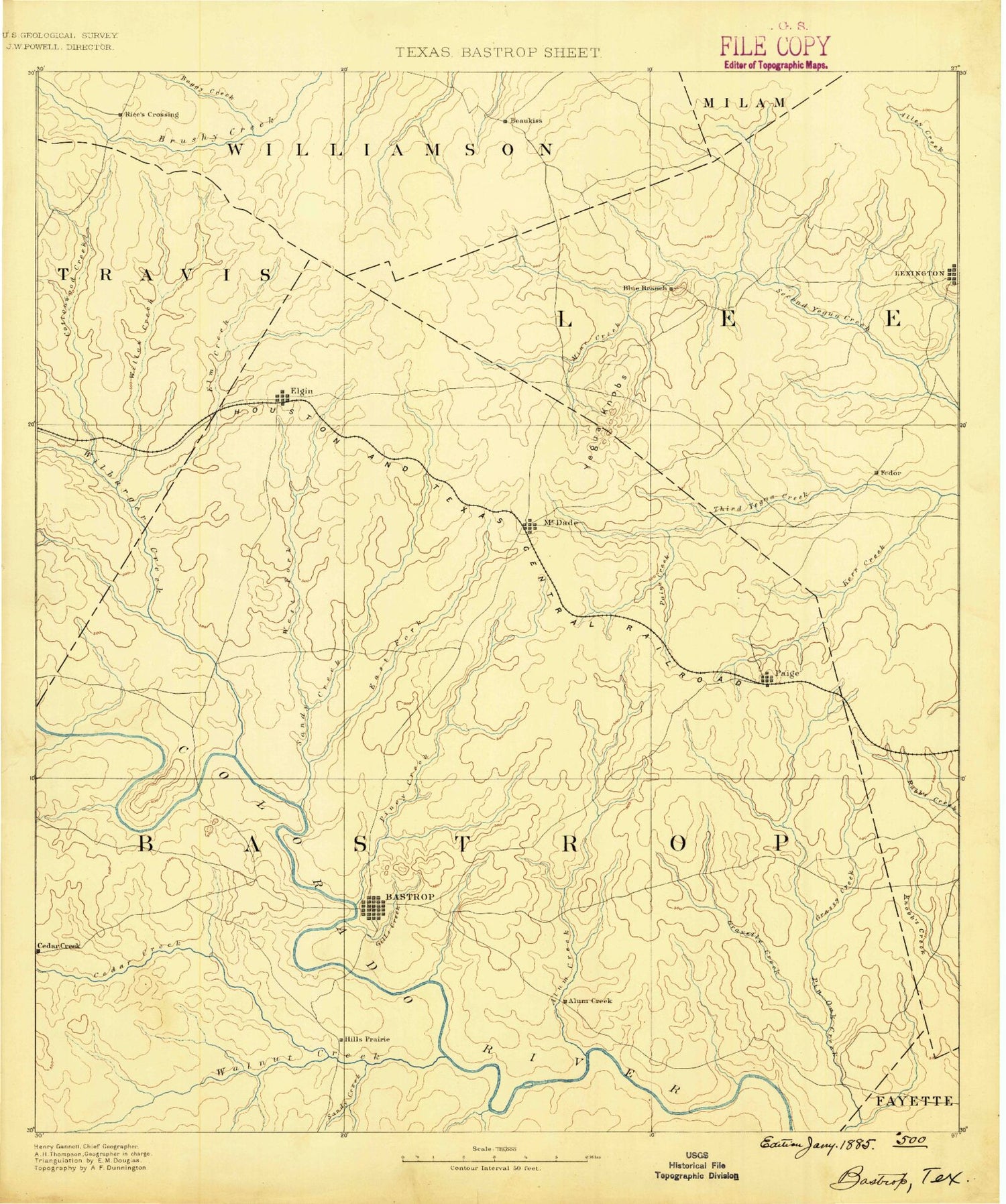
MyTopo
Historic 1885 Bastrop Texas 30'x30' Topo Map
Couldn't load pickup availability
Historical USGS topographic map of Bastrop in the state of Texas. Scale: 1:125000. Print size: 17" x 24"
This map was published in 1885 and is in the following counties: Bastrop, Fayette, Lee, Milam, Travis, Williamson.
The map contains contour lines, roads, rivers, towns, streams, and lakes. Printed on high-quality waterproof paper with UV fade-resistant inks.
Contains the following named places: Alum Branch, Alum Creek, Alum Creek, Bastrop, Bastrop State Park, Big Hollow, Bluff Creek, Buescher State Park, Butler, Caldwell Knob, Cedar Creek, Cedar Creek, Clearview, Coleman Branch, Copperas Creek, Cottonwood Creek, Crafts Prairie, David Bottom, Dogwood Creek, Dreissner Branch, Dry Creek, East Fork Gravelly Creek, East Rock Creek, West Rocky Branch, Garwood Ranch, Gills Branch, Goebel Store, Grassy Creek, Gravelly Creek, Greens Creek, Gum Spring Branch, Hardeman Bend, Harris Branch, Hemphill Bend, Hemphill Prairie, Hills, Hills Prairie, Humble Camp, J D Creek, Kennedy Bluffs, Knobbs Creek, Krones Creek, Littig, Little Alum Creek, Little Lake, Little Sandy Creek, Live Oak Branch, Long Branch, Long Branch, Long Branch, Long Prairie Branch, Maha Creek, Marshy Branch, McDade, McLaughlin Creek, Mid Springs Creek, Moss Branch, Mourn Lake, Paige, Paint Creek, Pigeonroost Hollow, Piney Creek, Pope Bend, Powell Bend, Price Creek, Red Bluffs, Red Gully Creek, Reed Bend, Rocky Creek, Sayersville, Shaw Lake, Spicer Creek, The Knobbs, Turner Creek, West Fork Gravelly Creek, East Rocky Branch, Wilbargers Bend, Willie Branch, Winchester, Yegua Knobbs, Abbott Oil Field, Hunt Branch, Avery Branch, Beaukiss, Boggy Creek, Camp Branch, Carlson, Clay Hill, Cottonwood Creek, Coupeland Branch, Coupland, Cross Creek, Burns Branch, Houghton Branch, Knight Branch, Lexington, Lund, Manda, Morrison Springs Branch, Pucker Springs Branch, Pucker Springs Creek, Rices Crossing, Sand Branch, Shaw Branch, Siloam, Slaughter Branch, Walleye Creek, Wilbarger Creek, Dead Mans Hole Creek, Poyston School, Big Sandy Creek, Blue Branch, Burlson Creek, Cottonwood Creek, Dry Creek, Dry Creek, Elgin, Elm Creek, Gazley Creek, Lentz Branch, Line Creek, Little Alum Creek, Little Piney Creek, Little Sandy Creek, Lower Cedar Hollow, Marshy Branch, Mill Creek, Mine Creek, Owens Branch, Piney Creek, Red Branch, Reeds Creek, Sandy Creek, Sandy Creek, Smithville, Spaulding, Two Mile Branch, Walnut Creek, Willow Creek, Willow Creek, Willow Creek, Willow Creek, Wolf Creek, Alum Creek, Fedor, Manheim, Phelan, Pin Oak, Upton, Utley, Adina, Bastrop County, Blue, Normans Crossing, Hills Prairie, Soil Conservation Service Site 32 Dam, Soil Conservation Service Site 32 Reservoir, Soil Conservation Service Site 12 Dam, Soil Conservation Service Site 12 Reservoir, Soil Conservation Service Site 13 Dam, Soil Conservation Service Site 13 Reservoir, Hamff Lake Number 1 Dam, Hamff Lake Number 1, Hamff Lake Number 2 Dam, Hamff Lake Number 2, Hamff Lake Number 3 Dam, Hamff Lake Number 3, Field Lake Dam, Fields Lake, Droemer Dam, Droemer Lake, Buescher State Park Lake Dam, Buescher Lake, Indian Lake Dam, Indian Lake, Harmon Dam, Harmon Lake, Lake Thunderbird Dam, Lake Thunderbird, Clear Springs Lake Dam, Clear Springs Lake, Sanders Dam, Sanders Lake, Bastrop State Park Dam, Bastrop State Park Lake, Lake Bastrop Dam, Lake Bastrop, Tahitian Village Dam, Tahitian Village Lake, Lincoln Dam, Lincoln Lake, A J Rod Dam, A J Rod Lake, Lazy S Ranch Dam, Sellers Lake Dam, Sellers Lake, Tuck Lake Dam, Tuck Lake, Hicks Lake Dam, Hicks Lake, Smith Lake Dam, Smith Lake, Egger Lake Dam, Egger Lake, Brockstein Lake Dam, Brockstein Lake, Voss Lake Dam, Voss Lake, Duke Lake Number 1 Dam, Duke Lake Number 1, Duke Lake Number 2 Dam, Duke Lake Number 2, Rod Lake Number 1 Dam, Rod Lake Number 2 Dam, Rod Lake Number 2, Parker Lake Dam, Parker Lake Dam, Casper Lake Dam, Casper Lake, Domaschk-Biar Lake Dam, Domaschk-Biar Lake, Golub Lake Dam, Golub Lake, Caraway Lake Number 1 Dam, Caraway Lake Number 1, Caraway Lake Number 2 Dam, Caraway Lake Number 2, Draeger Lake Dam, Draeger Lake, Camp Swift, Wyldwood, Bastrop Division, Cedar Creek-Red Rock Division, Elgin Division, Lexington Division, Shiloh