MyTopo
Historic 1890 Bedford Virginia 30'x30' Topo Map
Couldn't load pickup availability
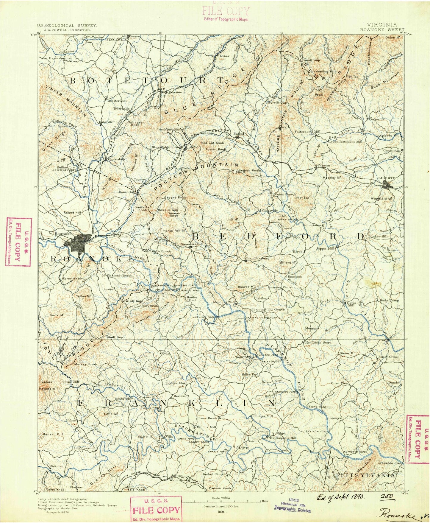
Historical USGS topographic map of Bedford in the state of Virginia. Scale: 1:125000. Print size: 17" x 24"
This map was published in 1890 and is in the following counties: Bedford, Botetourt, Franklin, Pittsylvania, Roanoke, Roanoke (city).
The map contains contour lines, roads, rivers, towns, streams, and lakes. Printed on high-quality waterproof paper with UV fade-resistant inks.
Contains the following named places: Back Creek, Beckys Creek, Bettys Creek, Blackwater River, Body Camp, Body Camp Creek, Bold Branch, Bonbrook, Bramletts Mountain, Breezy Point, Broad Ridge, Buck and Doe Mountain, Buck Run, Buff Creek, Bull Run, Cattail Hollow, Chestnut Level, Clover Creek, Clower Knob, Coles Creek, Coles Knob, Cool Branch, Craddock Creek, Cragged Branch, Creasey Mill Creek, Crowell Gap, Dark Hollow, Difficult Creek, Dillons Mill Branch, Elk Creek, Enochs Creek, Falling Rock Falls, Fiddler Creek, Fitzpatrick Branch, Foul Ground Creek, Gap of Smith Mountain, Gills Creek, Graves Store, Green Mountain, Green Ridge, Grimes Creek, Hales Creek, Harvey Creek, Hatcher Creek, Hatfield Creek, Hay Run, Haystack Mountain, Helm, Hendricks Store, Hickory Lake, High Knob, Horse Pen Branch, Horseshoe Branch, Hunting Creek, Indian Creek, Jumping Run, Kates Creek, Lick Mountain, Lick Run, Little Bull Run, Little Creek, Little Ellie Creek, Little Lynville Creek, Little Mountain, Louse Creek, Lynville Creek, Madcap Creek, Maggodee Creek, Maple Branch, Maple Branch, Mattox Creek, McIlhaney Hill, Mead Mountain, Meadow Ridge, Meads Store, Merriman Run, Mill Creek, Mob Creek, Mollie Branch, Moneta, Mooman Creek, Mosely Mountain, Murray Gap, Murray Knob, Niagara Power Plant Dam, North Fork Gills Creek, Panther Knob, Pilot Mountain, Pine Mountain, Poplar Camp Creek, Powder Mill Creek, Prater Creek, Radford, Read Mountain, Redwood, Roanoke Mountain, Rockcastle Creek, Rocky Branch, East Fork Beaverdam Creek, Middle Fork Beaverdam Creek, Zimmerman Mountain, Shockoe Creek, Shorts Gap, Shoulder Run, Saunders Pond, Standiford Creek, Stone Mountain, Stony Creek, Sunset Lake, Tanker Creek, Teels Creek, The Meadows of Goose Creek, Tick Branch, Timber Ridge, Tom Branch, Tory Knob, Trough Run, Walton Creek, White Oak Creek, Wiggington Knob, Windy Gap, Witcher Creek, Wolf Creek, Booker T Washington National Monument, Thaxton Mountain, Bunker Hill, Burnt Chimney, Crossroads, Diamond Hill, Dugwell, Five Forks, Gogginsville, Goodview, Hardy, Irving, Joppa Mill, Meador, Red Valley, Shady Grove, Wirtz, Mud Lick Creek, Buck Mountain Overlook, Chestnut Ridge, East Ridge, Elmwood Park, Eureka Park, Fallon Park, Fern Park, Fishburn Park, Garnand Branch, Ghent Park, Gum Spring Branch, Highland Park, Jackson Park, Lakewood Park, Lick Run, Maher Field, Mill Mountain Park, Morningside Park, Murray Run, Norwich Park, Ore Branch, Peters Creek, Raleigh Court Park, Shrine Hill Park, South Roanoke Park, Thresher Park, Towers Shopping Center, Wasena Park, Washington Park, Welford Hurt Park, Woodland Park, Angell Branch, Back Creek, Bearwallow Gap, Beaverdam Creek, Beaverdam Creek, Beckner Branch, Bedford Reservoir, Black Rock Hill Overlook, Blackhorse Gap, Bobblets Gap, Bonsack, Bore Auger Creek, Buffalo Creek, Camp Bethel, Camp Creek, Campbells Mountain, Carvin Cove Reservoir, Carvin Creek, Chair Rock Hollow, Chair Rock Ridge, Chestnut Mountain, Cobbs Gap, Cook Creek, Coyner Branch, Coyner Springs, Curby Branch, Curry Creek, Curry Gap, Day Creek, Ellis Run, Falling Creek, Fallingwater Creek, Fallingwater Overlook, Flat Top Mountain, Flat Top Mountain Overlook, Flat Top Mountain Trail, Flattop, Fullhart Knob, Glade Creek, Glove Creek, Goose Creek Valley Overlook, Great Valley Overlook, Hammond Hollow Trail, Hanging Rock Hollow, Harveys Knob Overlook, Headforemost Mountain, Headforemost Mountain Overlook, Hemp Mill Branch, Horsepen Mountain, Iron Mine Hollow Overlooks, Laymantown Creek, Lees Creek, Little Stony Creek, McFalls Mountain, McFalls Ridge, Mill Creek, Mills Gap Overlook, Montvale Overlook, Montvale Wayside, Mount Union, Murrill Gap, Nat Branch, Norfolk and Western Overlook, North Fork Goose Creek