MyTopo
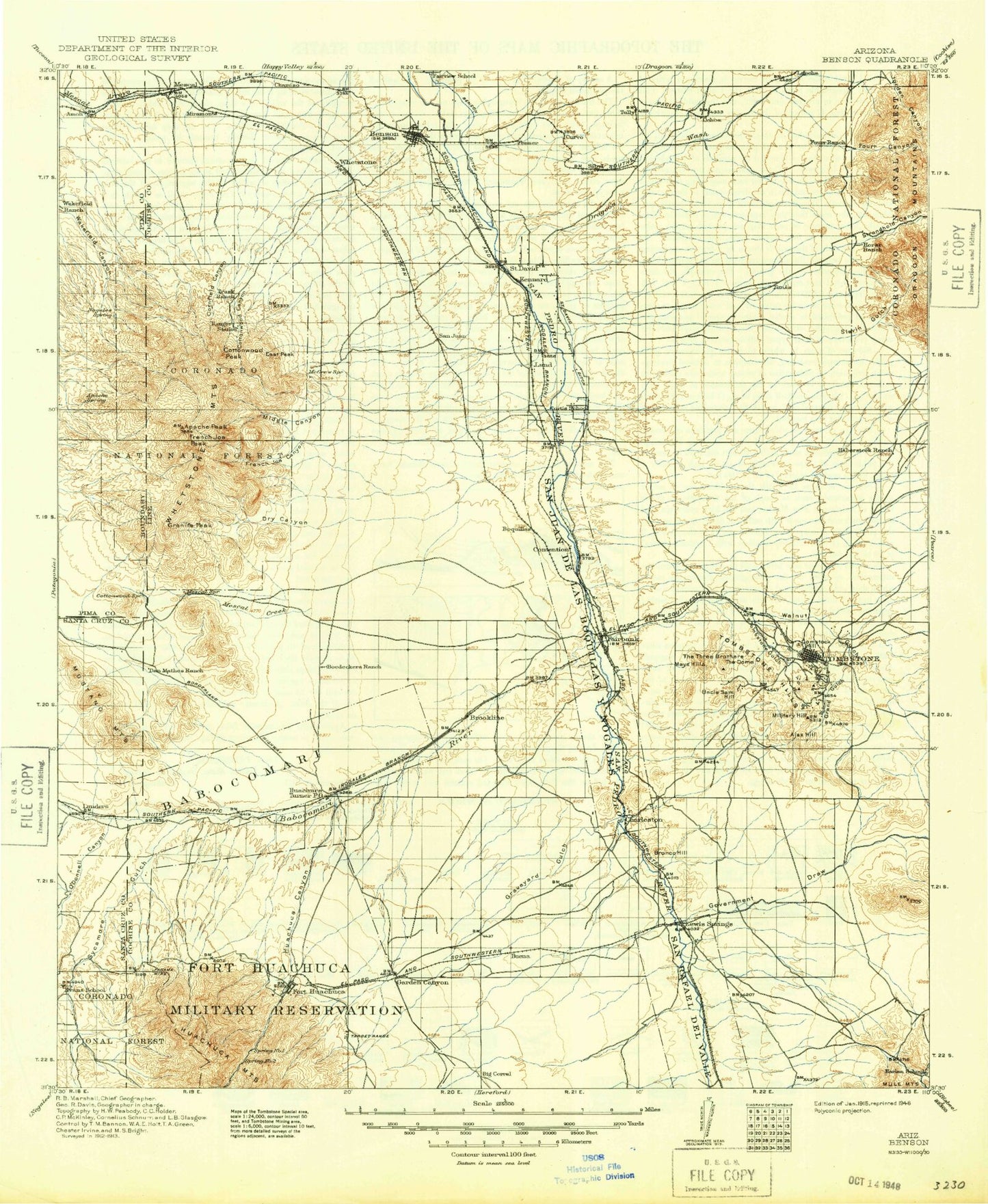
Historic 1915 Benson Arizona 30'x30' Topo Map
Couldn't load pickup availability
Historical USGS topographic map of Benson in the state of Arizona. Scale: 1:125000. Print size: 17" x 24"
This map was published in 1915 and is in the following counties: Cochise, Pima, Santa Cruz.
The map contains contour lines, roads, rivers, towns, streams, and lakes. Printed on high-quality waterproof paper with UV fade-resistant inks.
Contains the following named places: Ajax Hill, Apache Flats, Bakarich-McCool Ranch, Bennett Tank, Benson, Boedecker Tank, Boquillas Ranch, Brunckow Hill, Cedar Tank, Charleston Lead Mine, Clay Tank, Clifford Wash, Comstock Hill, Council Rocks, Coyote Tank, Curtis Tank, Curtis Wash, Curtis Windmill, Donnet-Fry Ranch, Dragoon Wash, Drew Tank, Emerald Gulch, Escalante Wash, Fourr Canyon, Fox Ranch, Fry, Garden Ridge, Government Draw, Graveyard Gulch, Guthrie Ranch, Haberstock Hill, Haberstock Wash, Henderson Wash, Homestead Tank, Horse Ranch, Huachuca City, Hunt Ranch, Johnson Ranch, Kellar Ranch, Keller Ranch, Knob Hill, Land, Laundry Ridge, Lindsey Ranch, Lonesome Valley, Lucky Hills Stock Ranch, Mays Hills, Military Hill, Murphy Tank, Packard Tank, Pomerene, Pomerene Canal, Post Ranch, Reeves Creek, Road Tank, Robertson Wash, Rock Ranch, Rock Spring Canyon, Saint David, Saint David Ditch, San Juan de las Boguillas y Nogales, San Rafael del Valle, Section Thirty Windmill, Sheep Wash, Sierra Vista, Slavin Gulch, Slavin Wash, Smith Hill, Smith Wash, Soldier Creek, Stone Ridge, Stronghold Canyon West, The Dome, The Three Brothers Hills, Tombstone, Tombstone Gulch, Tombstone Hills, Trappman Ranch, Uncle Sam Hill, Walnut Gulch, Willow Wash, Bella Vista Neighborhood Park, Busby Park, Chaffee Field Parade Ground, Cochise Plaza Shopping Center, Coronado Village Shopping Center, East Gate, Fairbanks Park, Huachuca Substation, Hunt Park, Kartchner Substation, Landin Park, Pyeatt Tank, Saint David Substation, Sierra Vista City Park, Tombstone City Park, Boquillas, Campstone, Chamiso, Contention, Curtiss, Escalante Crossing, Fenner, Lewis Springs, Whetstone, Benson Junction, Bonnie Blink, Cavalay Park, Coronado Village, De Anza Village, East Pershing Plaza, Gatewood Housing, Miles Manor, Signal Village, Tully, Village Meadows, West Pershing Plaza, Huachuca Canyon, Slaughter House Wash, Algerita Canyon, Anderson Mine, Apache Peak, Babocomari Ranch, Babocomari River, Bates Tank, Becker Ranch, Bill Williams Tank, Blacktail Canyon, Blacktail Wash, Boss Ranch, Boulder Tank, Mount Bruce, Brushy Canyon, Buffalo Corral, Burro Gap, California Wash, Cemetery Canyon, Cherry Canyon, Corner Tanks, Cottonwood Canyon, Cottonwood Peak, Cottonwood Saddle, Coyote Canyon, Cumaro Wash, Death Trap Canyon, Demonstration Hill, Dirt Tank, Double X Ranch, Dry Canyon, East Peak, East Tank, Easter Mountain, Ferosa Canyon, Finley Tank, Flying B Ranch, French Joe Camp, French Joe Canyon, French Joe Peak, French Joe Tank, Granite Peak, Guindani Canyon, H & D Mine, Haystack Mountain, Highway Tank, Jay Six Ranch, Jog Tank, Lobo Pass, Lone Pine Saddle, Lower Tank, Lyle Canyon, Manila Canyon, Manila Mine, Marshall Ridge, McNalley Tank, Mesa Tank, Mescal, Mescal Creek, Mesquite Tank, Middle Canyon, Middle Canyon Wash, Middle Tank, Mine Canyon, Mustang Mountains, Mustang Peak, Page Ranch, Pyeatt Ranch, Rain Valley, Rain Valley Ranch, Ramsey Tank, Ricketts Mine, Rough Canyon, Round Corral, Sacaton Tank, Sacaton Wash, San Ignacio del Babocomari, Sands Ranch, Sands West Camp, South Fork Middle Canyon, Split Rock Canyon, Swinging H Ranch, Sycamore Canyon, The Cape, Turkey Creek, Twin Buttes, Upper Tank, Vaughn Canyon, Whetstone Mountains, White Tank, Wild Cow Canyon, Williams Ranch, Willow Canyon, Woodcutters Canyon, Woodyard Canyon, North West Dome, Rose Tree Ranch, Sycamore Gulch, Great Spring Tank, Kinsley Tank, Lone Star Mine, B Smith Ranch, Sibyl, Pimaco Two, O'Donnell Canyon, Kartchner Caverns State Park, San Pedro House, San Pedro Riparian National Conservation Area, Sierra Vista Division, Tombstone Courthouse State Historical Park, City of Benson, City of Sierra Vista, City of Tombstone, Town of Huachuca City, Cochise County Western Regional Landfill, Huachuca City Landfill, Whetstone Business Park, The Mall at Sierra Vista