MyTopo
Historic 1890 Benton Arkansas 30'x30' Topo Map
Couldn't load pickup availability
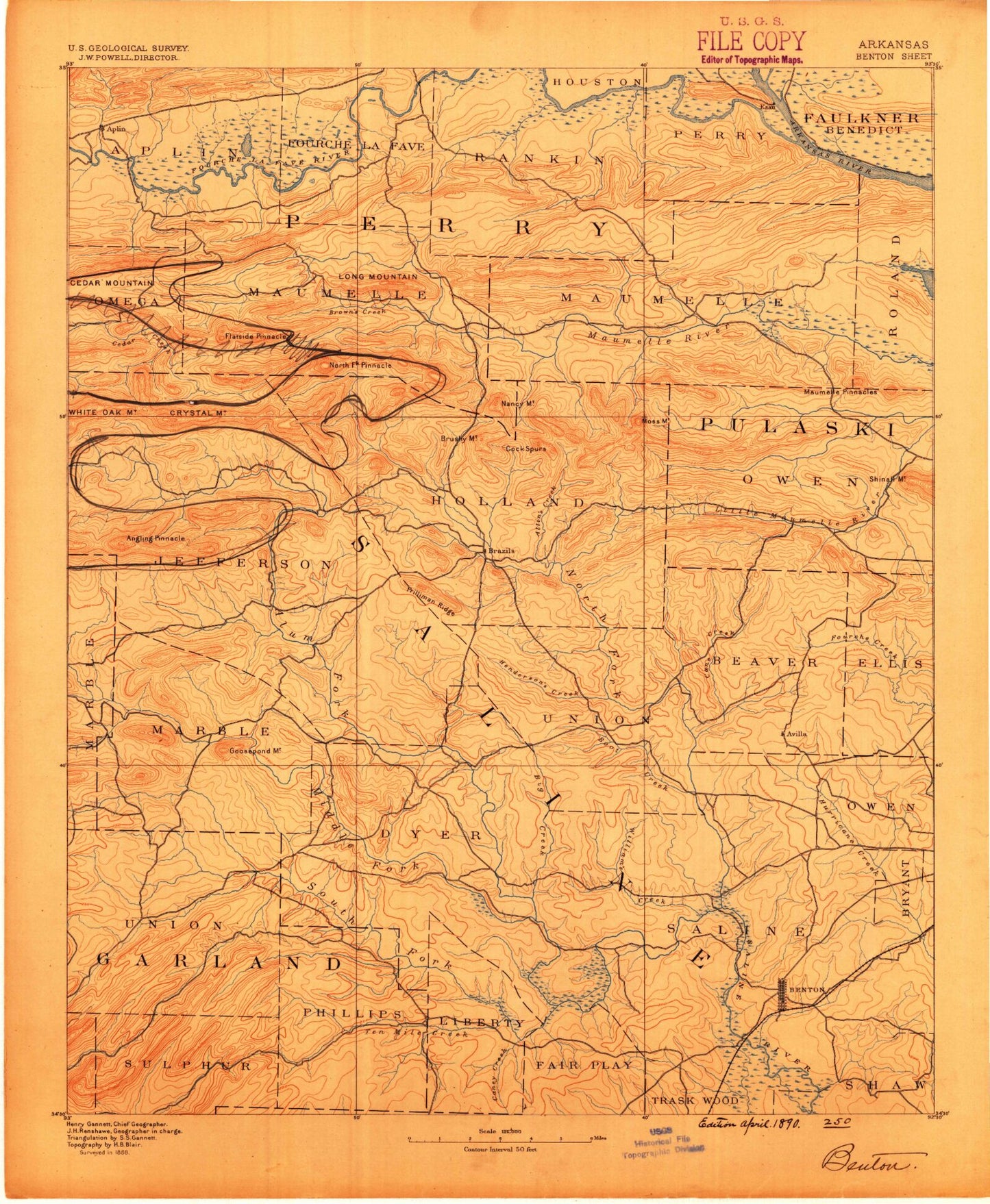
Historical USGS topographic map of Benton in the state of Arkansas. Scale: 1:125000. Print size: 17" x 24"
This map was published in 1890 and is in the following counties: Faulkner, Garland, Hot Spring, Perry, Pulaski, Saline.
The map contains contour lines, roads, rivers, towns, streams, and lakes. Printed on high-quality waterproof paper with UV fade-resistant inks.
Contains the following named places: Allens Creek, Arkansas Baptist Camp, Benton, Big Branch, Big Creek, Big Ridge, Boardtree Branch, Boot Creek, Bringle Creek, Brushy Creek, Call Hollow, Caney Creek, Caney Creek, Caney Creek, Cave Creek, Cock Spurs, Cole Mountain, Crows, Crystal Mountain, Deerlick Creek, Depot Creek, Devils Hollow, Dobbs Creek, Dog Creek, Dry Branch, Dry Creek, Easterwood Mountain, Fall Mountain, Ferncliff Camp, Flat Mountain, Fletcher Creek, Fourche, Grapevine Mountain, High Point, Hog Creek, Holliday Creek, Holliday Mountain, Holly Creek, Holmes Hollow, Kenney Mountain, Kryer Mountain, Lamb Creek, Little Hurricane Creek, Little Italy, Lockett Creek, Logan Creek, Long Hollow, Lonsdale, Lyle Park, Martindale, Maumelle Harbor, Maxwell Hollow, McNeil Creek, Mill Creek, Mill Creek, Mill Creek, Moccasin Creek, Moore Branch, Moss Mountain, Moss Mountain, Mud Hole Branch, Neal Creek, Nowlin Creek, Owensville, Pfeifer Camp, Pigeon Roost Mountain, Pilot Knob, Pleasant Run Creek, Pleasant Valley, Rankin Creek, Reece Creek, Rock Creek, Ross Hollow, Rush Hollow, Salem, Salt Creek, Shockley Branch, South Fork Saline River, South Tenmile Creek, Spring Branch, Stillhouse Hollow, Taylor Creek, Taylor Creek, Turkey Creek, Turkey Swamp, Tyndall Park, Wilhite Hollow, Williams Creek, Winford Brake, Worthen Creek, Wye Mountain, Avilla, Ledwidge, Lundsford Corner, Wye, Bauxite, Bauxite Junction, Bullard Mountain, Cold Spring Mountain, Congo, Ferndale, Fountain Lake, Goodson Mountain, Grindstone Mountain, Haskell, High Point, Horseshoe Mountain, Jennings Mountain, Ketchel Mountain, Morning Star, Nance, Rattlesnake Mountain, Round Mountain, Rubicon, Schoolhouse Mountain, Whittington, Balboa Golf Course, Cortez Golf Course, Busby Shoals, Graytown, Harris Brake State Wildlife Management Area, Houston Creek, Lake Sylvia Recreation Area, Lee Shoals, May Shoals, The Narrows, Oak Grove, Rock Creek Lake, Tyler Shoals, West Aplin, Benton Square Shopping Center, Bernard W Holland Park, Bland, Dotson Branch, Edgewood, Ferguson Plaza Shopping Center, Blocher, Coronado Golf Course, Grape, Hickory Flats, Kentucky, Lena, Lewis Stadium, Lincoln Square Shopping Center, Longhills Golf Course, Masoner Lake, Military Plaza Shopping Center, Niloak Shopping Center, Richardson Place, Saine County Fairgrounds, Sherwood Estates, Township of Benedict, Township of Whittington, Goosepond Mountain, Township of Bauxite, Township of Beaver, Township of Dyer, Township of Fairplay, Township of Haskell, Saline County, Ball Mountain, Bland Hollow, Camp Grundy, Camp Okatoma, Dead Horse Branch, Jolly Roger Landing, Moyer Mountain, Northpoint, Patterson Branch, Slaty Branch, Stillhouse Branch, Wilford Peak, Wilhite Branch, Wolf Hollow, Beauchamp Branch, Hamma Branch, Holly Springs, Township of Aplin, Township of Cherry Hill, Township of Kenney, Township of Maumelle, Township of Rankin, Township of Union Valley, Township of Wye, Township of Holland, Township of Jefferson, Township of Kentucky, Township of Liberty, Township of Marble, Township of Newcomb, Township of Salem, Township of Union, Perry County, Alum Fork Saline River, Angling Creek, Angling Pinnacle, Antioch, Aplin, Beaver Pond Mountain, Bell Branch, Big Branch, Big Branch, Big Huston Creek, Bills Branch, Bob Neal Branch, Bread Creek, Bread Creek Pinnacle, Brown Creek, Brushy Creek, Brushy Mountain, Bull Lake Slough, Calfneck Bend, Camp Ouachita, Cedar Creek, Cedar Creek, Chinquapin Mountain, Clayton Branch, Coffee Creek, Cove Creek, Crystal Mountain, Crystal Prong, Cypress Creek, Flatside Pinnacle, Gillis Branch, Greathouse Creek, Grindstone Mountain, Horsely Branch, Horseshoe Bend, Hot Springs Village, Little Alum Fork, Little Huston Creek, Long Mountain, Love Creek, Lyons Branch, Middle Fork Saline River, Mill Creek