
MyTopo
Historic 1890 Bessemer Alabama 30'x30' Topo Map
Couldn't load pickup availability
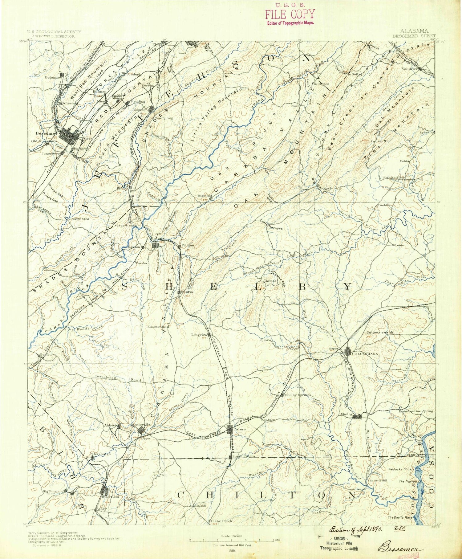
Historical USGS topographic map of Bessemer in the state of Alabama. Scale: 1:125000. Print size: 17" x 24"
This map was published in 1890 and is in the following counties: Bibb, Chilton, Coosa, Jefferson, Shelby, Talladega.
The map contains contour lines, roads, rivers, towns, streams, and lakes. Printed on high-quality waterproof paper with UV fade-resistant inks.
Contains the following named places: Nabors Branch, Thomas Branch, Acton, Acton, Acton Creek, Acton Lake, Aiken Creek, Alabaster, Aldrich, Allen Brook, Almont, Alpines Lakes, Anders Branch, Avalon Park, Bailey Brook, Bailey Brook, Bailey Gap, Baker Point, Batson Lake, Beaver Creek, Bee Mountain, Bee Ridge, Beech Branch, Beeswax Creek, Belcher Lake, Belle Haven, Belwood, Berney Points, Bessemer, Bessemer Gardens, Bessemer Homestead, Beverly Station, Big Branch, Big Branch, Big Creek, Murry Creek, Big Narrows, Big Sucker Brook, Black Branch, Black Creek, Blue Lake, Blue Pond, Bluff Park, Bluff Ridge, Bob George Branch, Bob Hood Branch, Bolivar Creek, Bon-Air, Boothton Station, Bounds Lake, Boyden Lake, Brasher Branch, Brighton, Brooklane Place, Brown Branch, Brownville, Buena Vista Highlands, Bulley Creek, Bush, Butler Hollow, Lake Byram, Cahaba Heights, Cahaba Lake, Cahaba River Estates, Cahaba Valley Creek, Camp Branch, Camp Branch, Camp Branch, Camp Horne, Cedar Lake, Central Park, Central Park Highlands, Chapel Hill, Charob Lake, Chelsea, Chelsea Game Preserve Lake, Cherokee Forest, Chestnut Ridge, Clear Branch, Clear Branch Gap, Clear Creek, Clear Prong, Coagie Branch, Coal Branch, Coales Branch, Coalmont, Cobb Creek, College Lake, Columbiana Mountain, Cooper Branch, Coosa Mountain, Coosa Tunnel, Cottage Hill, Cow Gap, Cox Creek Point, Crawford Branch, Crescent Heights, Crystal Lake, Dargin, Davis Creek, Davis Falls, Devils Gap, Dividing Ridge, Lake Dixie, Dodd Branch, Dogwood, Dolly Brook, Dolly Ridge, Dolomite, Double Mountain, Double Mountain Branch, Double Oak Mountain, Dry Brook, Dry Creek, Dry Creek, Dry Creek, Dry Valley, Duck Branch, Dunavant, East Brighton, Eastern Valley, Edgemont, Edgemont Park, Edgemoor Estates, Edgewood, Elliott Yard, Elmore Lake, English Village, Enon Gap, Fairfield, Fairfield Highlands, Fairfield Village, Falling Rock, Finger Lake, Fleming Branch, Flint Ridge, Forest Hills, Four Wing Lake, Fourmile Creek, Fowler Lake, Fuller Creek, Fungo Hollow, Fungo Valley, Furnace Branch, Garnsey Number 2, Garywood, Genery, Germania, Lake Gizella, Glade Branch, Glen Carbon, Glen Hills, Glen Oaks, Glenview, Goat Island, Gold Ridge, Gordon Heights, Great Pine Lake, Green Acres, Greenacres Park, Greenwood, Griffin Brook, Grove Park, Gumsuck Branch, Gurnee, Halls Creek, Hancock Creek, Hardy, Harlem Heights, Harrison Park, Lake Helen, Hickory Grove, Hillman, Hillman Gardens, Hillman Park, Hogpen Creek, Hollywood, Holmes Branch, Holtzclaw Lake, Homewood, Honeysuckle Hills Park, Hooker Point, Hoover, Hopewell, Huckleberry Branch, Hudson Gardens, Hudson Grove, Hueytown Crest, Hurricane Branch, Hurricane Creek, Hyde Park, Ike Pond Slough, Indian Creek, Indian Spring Lake, Industrial City, Interurban Heights, Ivanhoe, Ivy Branch, Jesse Creek, Jims Branch, Johnson Branch, Johnson Brook, Johnson Mountain, Jones Ridge, Jones Valley, Jones Valley, Kates Branch, Kerscoha Lake, Keystone, King Creek, Lacey Branch, Laceys Chapel, Brantleyville, Lake Drive Estates, Lake Shore Estates, Lakeview Estates, Lakeview Park, Lakewood Estate, Lakewood Hills, Lane Park, Laurel Point, Lay Lake, Lee Branch, Lee Brook, Lick Creek, Lime Branch, Little Beeswax Creek, Little Creek, Little Deer Lakes, Little Island, Little Narrows, Little Narrows, Little Oak Ridge, Little Shades Creek, Little Shades Creek, Little Shades Mountain


