MyTopo
Historic 1943 Bethlehem Pennsylvania 30'x30' Topo Map
Couldn't load pickup availability
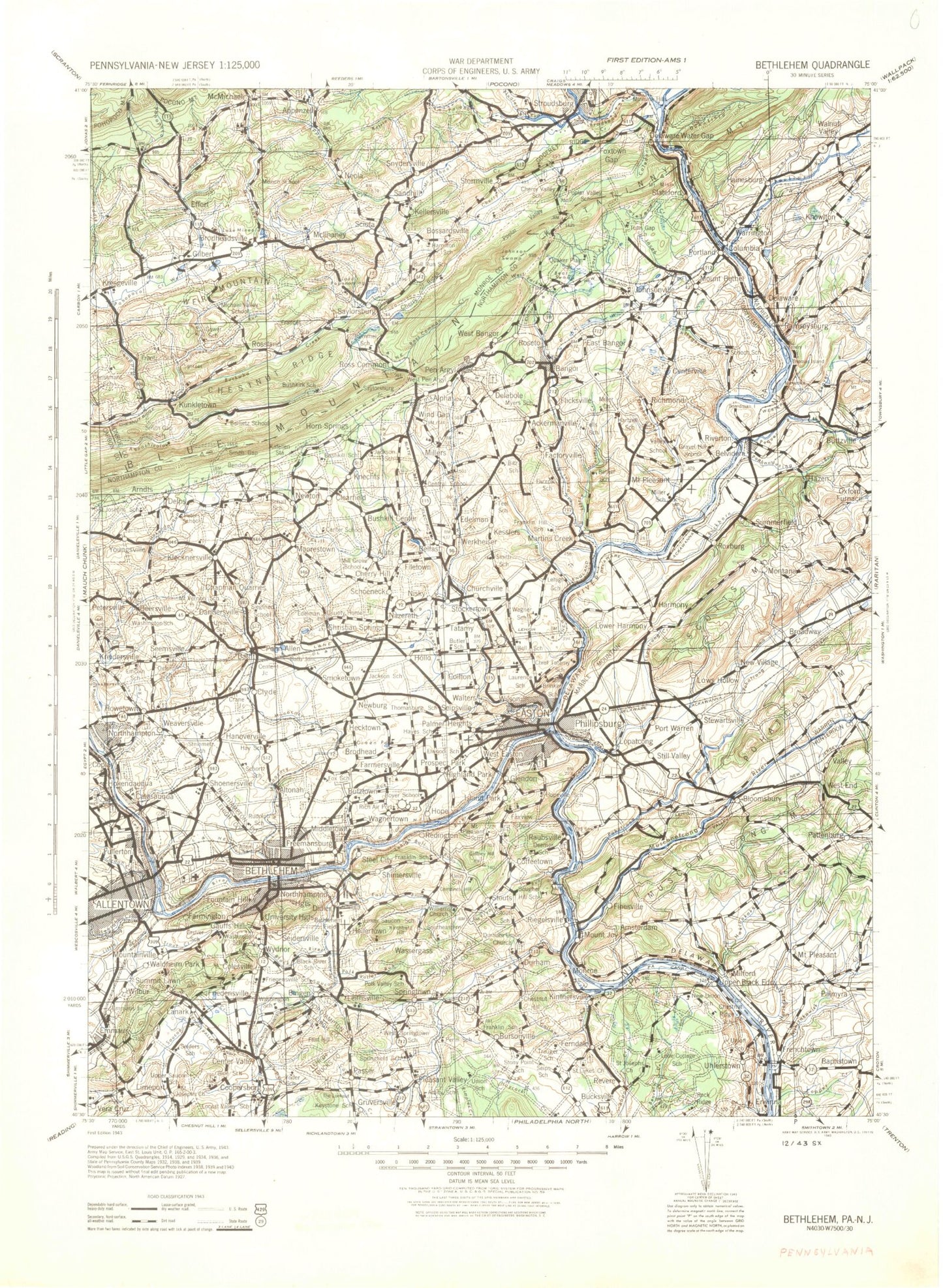
Historical USGS topographic map of Bethlehem in the state of Pennsylvania. Scale: 1:125000. Print size: 17" x 24"
This map was published in 1943 and is in the following counties: Bucks, Carbon, Hunterdon, Lehigh, Monroe, Northampton, Warren.
The map contains contour lines, roads, rivers, towns, streams, and lakes. Printed on high-quality waterproof paper with UV fade-resistant inks.
Contains the following named places: Capush Island, Foul Rift Islands, Foul Rift Falls, Ackermanville, Adams Island, Mount Airy, Lake Akiba, Allegheny Creek, Alpha, Alton Park, Amity, Appenzell, Appenzell Creek, Applebutter Hill, Arlington Heights, Arlington Knolls, Arlington Lake, Arrow Island, Attins Islands, Bangor, Bath, Bauer Rock, Bayard Park, Bear Swamp, Beersville, Belfast, Belfast Junction, Bethlehem, Bethlehem View, Bingen, Bitts Hill, Black River, Blue Mountain Pines, Bossardsville, Bougher Hill, Brainerd Center, Brodhead, Brodheadsville, Buckwampum Hill, Bursonville, Bushkill Center, Bushkill Park, Caledonia Creek, Camelhump, Camp Akiba, Camp Big Pocono, Camp Davis, Camp Dent, Camp Helena, Camp Nockamixon, Camp Trexler, Campbell Pond, Catasauqua, Catasauqua Lake, Center Valley, Chapman, Chapple Creek, Cheesebrough Pond, Cherry Creek, Cherry Hill, Cherry Ridge, Cherry Valley, Chestnut Hill, Chestnut Hill, Chestnut Hill, Chestnut Hill, Chicola Lake, Christian Springs, Christines Hill, Church Hill, Church Hill, Clearfield, Coffeetown, Coffman Hill, Coilton, Colesville, Condran Park, Cooks Creek, Coopersburg, Coplay, Coplay Creek, Cressman Hill, Crossroads, Crystal Hill, Delabole, Delaware Water Gap, Delta Manor, Dry Run, Durham, Durham Furnace, Dutch Hill, East Allentown, East Branch Saucon Creek, East Fork Martins Creek, East Hills, East Lawn, East Stroudsburg, Echo Lake, Edelman, Effort, Elephant Rock, Emanuelsville, Emmaus, Emmaus Junction, Erwinna, Evergreen Park, Eves Island, Fall Creek, Farmersville, Farmington, Ferndale, Five Points, Flagler Run, Flicksville, Flint Hill, Focht Hill, Fountain Hill, Fountain Park, Fox Gap, Foxtown Gap, Foxtown Hill, Foxtown Hill, Friedensville, Frys Run, Fullerton, Gaffney Hill, Gallows Hill, Gallows Run, Gauff Hill, Getters Island, Gilbert, Glendon, Godfrey Ridge, Grand Central, Granite Hill, Green Hill, Green Pond, Greenwalk Creek, Hackett Park, Hamilton Square, Hanover, Hanover Acres, Hanoverville, Harmony Grange, Hecktown, Heil Park, Heimple Park, Hellertown, Hellertown Reservoir, Hemlock Lake, Hexenkopf Hill, Hexenkopf Rock, Hiawatha Lake, Highland Park, Hokendauqua, Holiday Hill, Howertown, Irving Park, Island Park, Mount Jack, Jacksonville, Jacoby Creek, Jordan Creek, Jordan Park, Juniper Circle, Kaywin, Keck Park, Kellersville, Kemmererville, Kesslersville, Kettle Creek, Kingswood Estates, Kintnersville, Klecknersville, Klein Hill, Knechts, Kohlberg, Kreidersville, Kunkletown, Lake Creek, Lanark, Laurel Hill, Lehigh Mountain, Lehigh University Athletic Field, Leithsville, Limeport, Limeport Hill, Little Bushkill Creek, Little Lehigh Creek, Little Lehigh Park, Little Martins Creek, Little Pocono Creek, Lower Saucon, Lynn Island, Macada, Mack Park, Marlin Lake, Martins Creek, Masons Island, McElhaneys Island, McIlhaney, McMichael, McMichael Creek, Memorial Park, Meuser Park, Middletown, Midway Manor, Miller Manor, Miller Slate Pond, Mine Hill, Lake Mineola, Mount Minsi, Molasses Hill, Moorestown, Morgan Hill, Morgan Valley, Mount Pleasant, Mountainville, Moyers Lake, Mud Run, Nazareth, Nazareth Reservoir, Neola, Nevin Park, Newburg, Newburg Homes, North Bangor, North Catasauqua, Northwood Heights, Notre Dame Hills, Old Hound Ridge, Old Sow Island, Oughoughton Creek, Overlook Springs, Palmer Heights, Passer