MyTopo
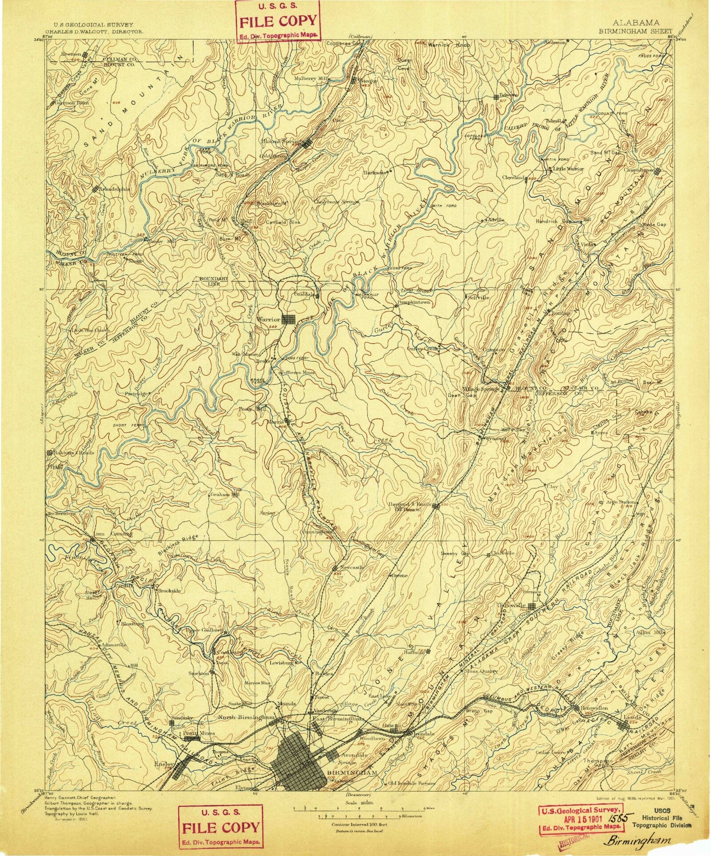
Historic 1895 Birmingham Alabama 30'x30' Topo Map
Couldn't load pickup availability
Historical USGS topographic map of Birmingham in the state of Alabama. Scale: 1:125000. Print size: 17" x 24"
This map was published in 1895 and is in the following counties: Blount, Cullman, Jefferson, Shelby, St. Clair, Walker.
The map contains contour lines, roads, rivers, towns, streams, and lakes. Printed on high-quality waterproof paper with UV fade-resistant inks.
Contains the following named places: Cornelius Mountain, Dry Creek, Abes Creek, Acipcoville, Adamsville, Adville, Airport Highlands, Alden, Allgood, Altamont Park, Altamont Park, Alton, Alton Lake, Andy Branch, Ann Johnson Mountain, Arkadelphia, Arkadelphia Mountain, Armstead, Avon Park, Avondale, Avondale Mills Park, Avondale Park, Bagley Ridge, Bains Bend, Barefoot Mountain, Barker Park, Barnisdale Forest, Barton Branch, Bartonville, Bay View, Bayview Lake, Beachwood Park, Bel Air, Bendale, Bentley Hills, Berkley Hills, Big Branch, Big Scirum Creek, Birmingham Terminal Station, Biscayne Highlands, Black Bottom, Black Creek, Black Creek, Black Creek, Black Creek, Blackburn Fork Little Warrior River, Black Oak Mountain, Blackwood Ponds, Blossburg, Blount Springs, Blount Springs Station, Blount Tunnel, Blow Gourd, Boyles Gap, Boyles Highlands, Bradford, Bremen, Brewer Creek, Brice Creek, Bridlewood Forest Estates, Brookhurst, Brookside, Browns Mountain, Brushy Mountain, Bryant Mountain, Burt Reid Mountain, Butler Mountain, Cahaba Crest, Cahaba Hills, Caldwell Park, Calvert Prong Little Warrior River, Camp Blossom Hill, Camp Branch, Camp Coleman, Camp Crosby, Camp Munger, Camp Tanglewood, Campbell Creek, Campbell Creek, Cane Creek, Cannon Mountain, Canoe Creek Lake, Cardiff, Cat Mountain, Causey Branch, Cave Hill, Cedar Springs, Center Point, Center Point Gardens, Centercrest, Centerwood Estates, Central Highlands, Chalkville, Cheney Branch, Chert Mountain, Chetopa, Chicken House Creek, Chinquapir Ridge, Chitwood Creek, Clarkton Creek, Clay, Clayton Cove, Clayton Park, Clear Branch, Clear Branch, Cloverdale, Coalburg, Coaldale, Corner, Country Estates, County Line, Cowden Gap, Creel, Crestline Gardens, Crestline Heights, Crestline Park, Crestview Hills, Crocker Hill, Crocker Mountain, Crooked Creek, Crosston, Crumley Chapel, Crump Branch, Crump Gap, Dairy Creek, Daisey City, Dallas, Danville, Dean Creek, Deavers Branch, Dillashaw Branch, Divide Station, Dollar Creek, Dorsey Creek, Double Branch, Douglasville, Downey Park, Drummond Hollow, Dry Creek, Dry Creek, Dry Creek, Dry Creek, Dry Creek, Dry Creek, Duffy Mountain, Duke Park, East Birmingham, East Haven, East Irondale, East Lake, East Lake Park, East Boyles, East Thomas, East Thomas Gardens, East Thomas Park, East Thomas Yards, Easterwood Mountain, Eastwood, Echo Lake, Edgewater, Edwards Lake, Ensley, Ensley Park, Euclid Estates, Exchange Park, Exum, Fair Haven Campsite, Fairfield, Fairview Park, Falls Junction, Farmers Market, Fernwood Estates, Fieldstown, Five Points East, Five Points South, Flat Creek, Flat Ridge, Floyd Creek, Follett Creek, Forest Acres, Forest Park, Forestdale, Foster Mountain, Fountain Heights, Fountain Heights Park, Frances Heights, Franklin Gardens, Fulton Springs, Fultondale, Gardendale, Gate City, Lake George, Gilliand Pond, Gilman Bend, Glasgow, Glencoe, Glendale, Godwin Estates, Goolsby Hollow, Gordons Dam, Gravel Ridge, Gravelly Ridge, Graymont, Graystone, Graysville, Greathouse Mountain, Greens Chapel, Greenleas Heights, Guinn Cove, Gurley Creek, Hair Bend, Halfway Branch, Hall Lake, Hall Mountain, Hallmark Creek, Hamilton Mountain, Hanover Park, Hanty Hollow, Happy Hollow, Harden Hollow, Harrell Cove, Harriman Park, Hayden, Hayden Mountain, Hayden Tunnel, Hayes Creek, Hayes Highland, Hayes Mountain, Henderson Creek, Hendrick Branch, Hendrick Mill Branch, Henry Ellen, High Rock, Highlands Park, Hobson, Hog Mountain