MyTopo
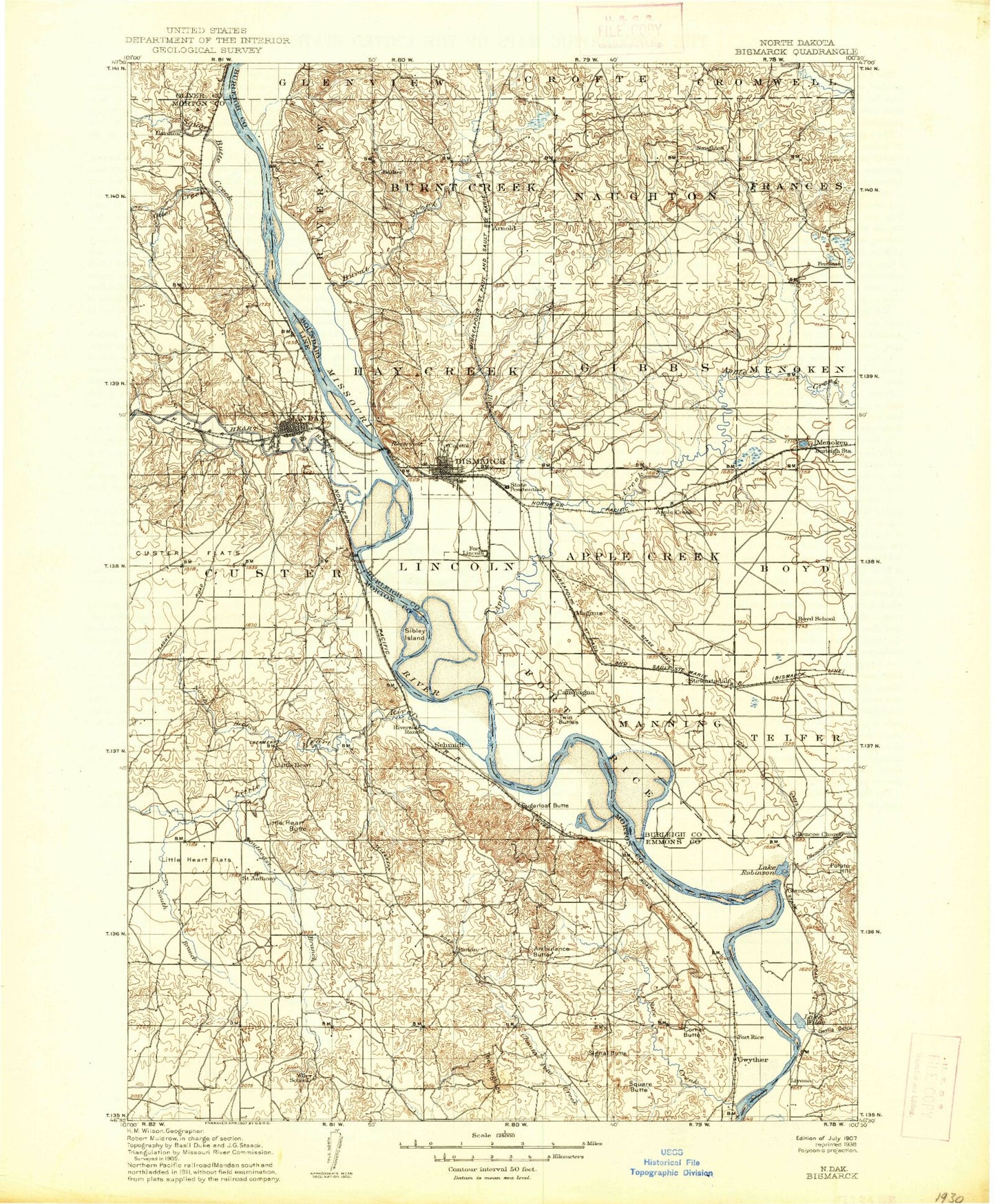
Historic 1907 Bismark North Dakota 30'x30' Topo Map
Couldn't load pickup availability
Historical USGS topographic map of Bismark in the state of North Dakota. Scale: 1:125000. Print size: 17" x 24"
This map was published in 1907 and is in the following counties: Burleigh, Emmons, Morton, Oliver.
The map contains contour lines, roads, rivers, towns, streams, and lakes. Printed on high-quality waterproof paper with UV fade-resistant inks.
Contains the following named places: Ambulance Butte, Apple Creek, Apple Valley, Arnold, Badger Bay, Badger Creek, Beaver Creek, Burnt Butte, Burnt Creek, Cave Coulee, Coal Butte, Corner Butte, Cottonwood Lake, Custer Flats, Custer Park, Cypert Park, Dakota Zoo, Dead Heart Slough, Devils Gulch, Eagles Park, Fork McKeen Historic Site, Fort Abraham Lincoln State Park, Fort Rice, Fort Rice Historical Site, Glencoe Creek, Hay Creek, Hillside Park, Huff, Keever Butte, Kiwanis Park, Little Heart River, Mandan, North Branch Little Heart River, Otter Creek, Pioneer Park, Potato Hill, Rattlesnake Butte, Rice Creek, Riverside Park, Rock Haven Creek, Saint Anthony, Schmidt, Signal Butte, Solberg Butte, South Branch Little Heart River, Southeast Branch Little Heart River, Spring Coulee, Square Butte Creek, Sugarloaf Butte, Sunny, Table Butte, The Hogback, Twin Buttes, McDowell Dam, Danielson Dam, Yegen Dam, Gateway Mall, Northbrook Shopping Center, Arrowhead Plaza, Kirkwood Plaza Shopping Center, Menoken, Lynwood, Livona, Double Ditch Indian Village, Harmon, Midway, Pierce, Rock Haven, Morton County State Game Management Area, Fort Rice Recreation Area, Hazelton Recreation Area, Wilde Lake, Carlson Lake, Litzman Ponds, Little Heart Recreation Area, Apple Creek Bottom, Sibley Nature Park, Schmidt Bottom, Kimball Bottom, Kimball Recreation Area, Sugarloaf Recreation Area, Graner Bottom, General Sibley Park Area, Heart River, Bismarck, Lincoln, City of Bismarck, City of Lincoln, Unorganized Territory of Mandan, City of Mandan, Township of Naughton, Township of Hay Creek, Township of Gibbs, Township of Apple Creek, Township of Boyd, Township of Francis, Township of Menoken, Township of Missouri, Township of Telfer, Township of Captain's Landing, Unorganized Territory of Burnt Creek-Riverview, Unorganized Territory of Lincoln-Fort Rice, Diamond R Ranch, Flying D Paint Ranch, Lazy T Diamond Ranch, Apple Creek Country Club, Pebble Creek Golf Course, Riverwood Golf Course, Mister Bs Estates, North Valley Park, Sky Way Mobile Home Park, Tatley Meadows, Colonial Estates, Hay Creek Court, Hillcrest Acres, Holiday Park, Stardust Terrace, Chance Mobile Home Park, Evas Mobile Home Court, Hi-loh Mobile Park, Parkview Estates, Terrace Heights Mobile Home Park, Bismarck Community Bowl, Frontier Homesteads, Kens Mobile Home Park, El Rancho Mobile Home Park, Twin City Estates, Wildwood Mobile Home Park, Meadow Park, Apple Creek East Bound Rest Area, Apple Creek West Bound Rest Area, Bismarck State College Aquatic and Wellness Center, Lone Star Arena, Hegeholz Field, Huff Indian Village State Historic Site, Dacotah Speedway, Huff Hills Ski Area, On-A-Slant Mandan Indian Village, Raging Rivers Waterpark, Harmon Lake