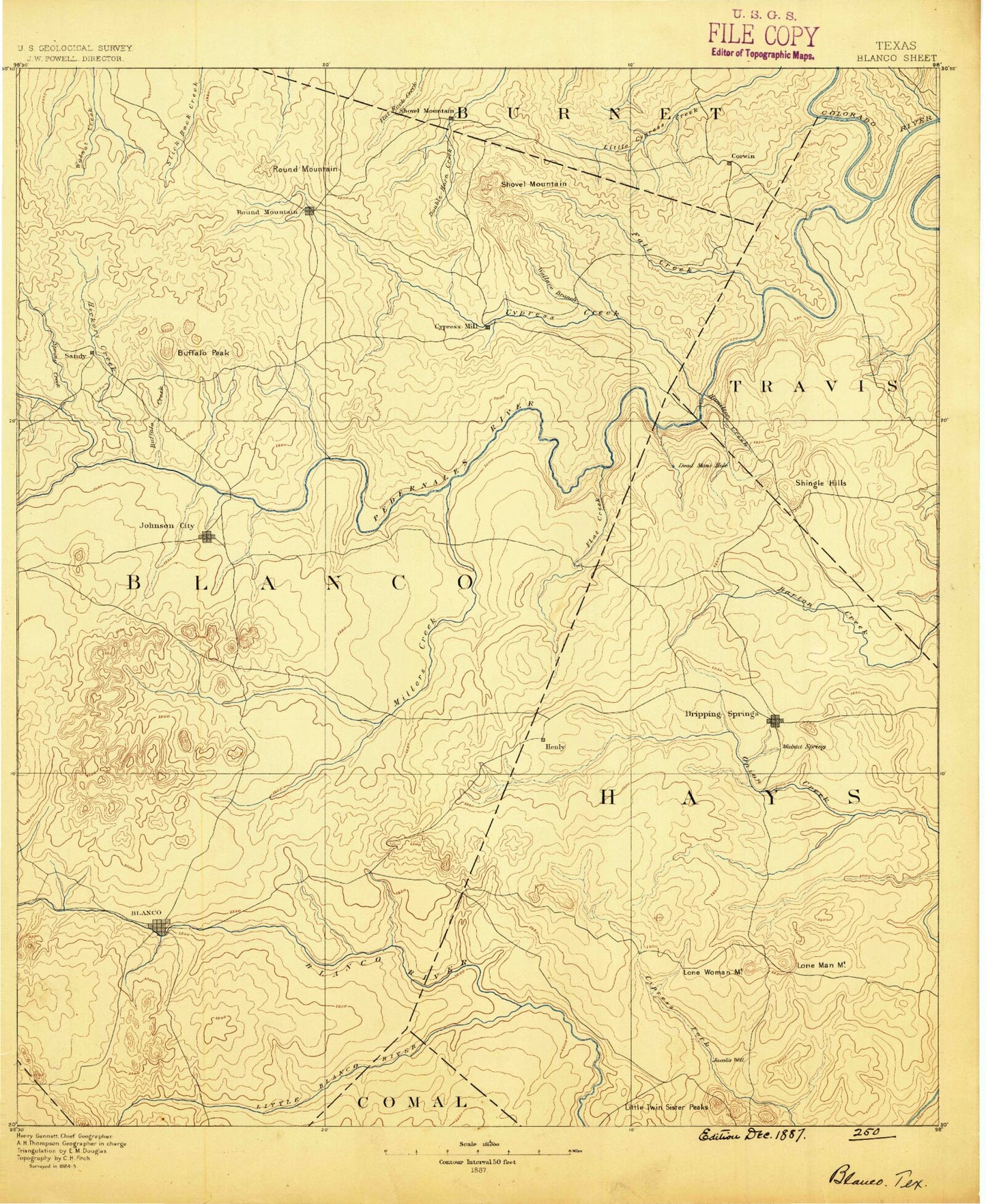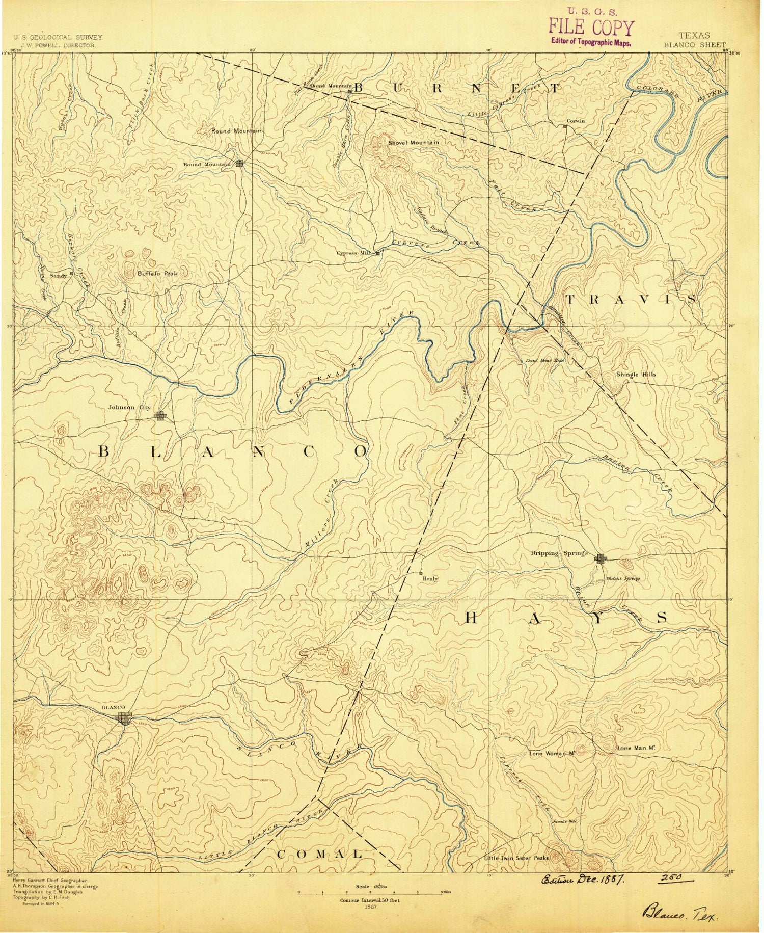
MyTopo
Historic 1887 Blanco Texas 30'x30' Topo Map
Couldn't load pickup availability
Historical USGS topographic map of Blanco in the state of Texas. Scale: 1:125000. Print size: 17" x 24"
This map was published in 1887 and is in the following counties: Blanco, Burnet, Comal, Hays, Kendall, Llano, Travis.
The map contains contour lines, roads, rivers, towns, streams, and lakes. Printed on high-quality waterproof paper with UV fade-resistant inks.
Contains the following named places: Brock Hollow, Miller Creek, Bates Creek, Bee Creek, Blanco, Blanco State Park, Blue Hole Campground, Boardhouse Creek, Brushy Top, Buffalo Peak, Cadell Branch, Calohan Creek, Camp Ben McCulloch, Cat Hollow, Cedar Fork, Chalk Bluff, Cistern Hollow, Cottonwood Branch, Cottonwood Branch, Cottonwood Creek, Cottonwood Creek, Cove Branch, Dead Mans Hole, Deer Creek, Dripping Springs, Durham Branch, Eagle Rock Ranch, East Fork Hinds Branch, Elm Hollow, Eskew Branch, Fitzhugh Creek, Flat Creek, Flat Creek, Flat Creek, Flat Creek, Freestone Branch, Gainor Mountain, Gatlin Creek, Greens Hollow, Grooms Branch, Hagerman Branch, Hamilton Creek, Hamilton Pool, Henly Branch, Hereford Hills Ranch, Hinds Branch, Hog Hollow, Jack Mountain, Jackson Branch, Joe Wimberley Mountain, Johnson City, Kentucky Branch, Koch Branch, Little Barton Creek, Little Twin Sister Peaks, Lone Man Mountain, Lone Woman Mountain, Manahan Creek, Martin Mountain, McCall Creek, McKinney Creek, Middle Creek, Millseat Branch, Millseat Branch, Monument Hill, Mustang Branch, Nagel Brothers Ranch, Newberry Ranch, North Grape Creek, Old Baldy, Peach Mountain, Pedernales Falls, Pier Branch, Rainbow Ranch, Rattlesnake Hollow, Robinson Community Hall, Rocky Branch, Rogers Branch, Rough Hollow, Rough Hollow, Roundtree Mountain, Roy Branch, Roy Creek, Russell Hollow, Salter Spring Creek, Schoolhouse Hollow, Schuetz Creek, Mount Sharp, Shingle Hills, Smith Creek, South Gatlin Creek, South Onion Creek, Sprouse Hollow, Storm Ranch, Stubbins Gap, Sycamore Creek, The Cove, The Narrows, Towhead Creek, Town Creek, Turkey Creek, Turkey Hollow, Turkey Hollow, Voyles Lazy V Ranch, Wanslow Creek, WE Four Ranch, White Branch, Yeager Creek, Camp Texlake, Carpenter Bend, Casner Gap, Cat Creek, Cedar Mountain, Cleveland Branch, Cow Creek, Flat Creek, Gloster Bend, Howell Mountain, Little Cypress Creek, Muleshoe Bend, Mustang Lake, North Cypress Creek, Pace Bend, Porter Gap, Post Oak Bend, Rattlesnake Mountain, Red Bluff Creek, Round Mountain, Round Mountain, Shovel Mountain, Shovel Mountain, Spicewood, Stribling Creek, Sycamore Creek, Taylor Lake, Therman Bend, Turkey Bend, Wallace Branch, West Ranch, Wilson Hollow, Big Mountain, Blasingame Creek, Buffalo Creek, Cottonwood Creek, Cypress Branch, Cypress Creek, Fall Creek, Hardin Russell Creek, Hickory Creek, Lick Creek, Little Blanco River, North Gatlin Creek, Rocky Creek, Spring Creek, West Fork Hinds Branch, Cambrian Creek, Pedernales River, Driftwood, Fitzhugh, Hammetts Crossing, Henly, Mount Gainor, Payton, Pleasant Valley Crossing, Sandy, Twin Sisters, Cypress Mill, Blanco County, Hays County, Woodcreek, Briarcliff, Lake Travis, Soil Conservation Service Site 1 Dam, Soil Conservation Service Site 1 Reservoir, Blanco City Dam Number 1, Blanco City Lake Number 1, Wayne Smith Dam, Wayne Smith Lake, Lake Johnson City Dam, Lake Johnson City, Reeves Lake Dam, Reeves Lake, Big Dam, Big Dam Lake, Purola Lake Dam, Purola Lake, Seven H Ranch Lake Dam, Seven H Ranch Lake, Tatum Lake Dam, Tatum Lake, Blanco Division, Dripping Springs-Wimberley Division, Johnson City Division, Southwest Travis Division, Blanco State Park, Hamilton Pool Park, Highland Lake, Pedernales Falls State Park, Pace Bend Park, Blanco Historic District, Doctor Joseph M and Sarah Pound Farmstead, Fou Mile Loop, Falls Trail, Blanco State Park Trail, Wolf Mountain Trail, Pace Bend Park Trail, Pedernales Falls State Park Equestrian Trails, Muleshoe Bend Trail, Hamilton Pool Park Trail, Grelle Recreation Area Trail, Shovel Mountain, City of Blanco, City of Johnson City, City of Dripping Springs, City of Woodcreek, Town of Round Mountain, Village of Briarcliff, Village of Point Venture, Cardium Creek, Spicewood Quarry, Love Creek