MyTopo
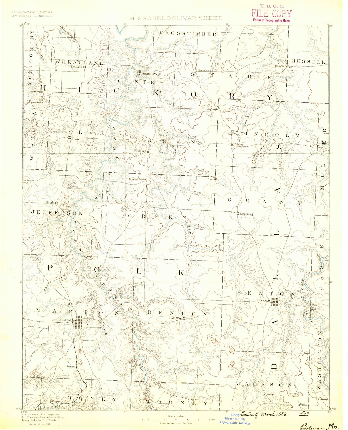
Historic 1884 Bolivar Missouri 30'x30' Topo Map
Couldn't load pickup availability
Historical USGS topographic map of Bolivar in the state of Missouri. Scale: 1:125000. Print size: 16" x 24"
This map was published in 1884 and is in the following counties: Camden, Dallas, Hickory, Polk.
The map contains contour lines, roads, rivers, towns, streams, and lakes. Printed on high-quality waterproof paper with UV fade-resistant inks.
Contains the following named places: Abels Branch, Ashlock Creek, Big Hollow, Big Hollow Branch, Bolivar, Branch, Brush Creek, Brush Creek, Buffalo, Burns, Cabbage Branch, Cahoochie Creek, Cave Spring Hollow, Cedar Hollow, Cedar Vista, Charity, Clark Branch, Claude Branch, Cliquot, Coatney Branch, Coatney Hollow, Crane Creek, Darby Branch, Davis Creek, Decker Branch, Dry Fork, Dunnegan Park, East Branch Cahoochie Creek, Elkhorn Hollow, Elkton, Flint Creek, Goodson, Gooseneck Branch, Gower Branch, Graveyard Hill, Green Branch, Hermitage, Hog Eye Branch, Horn Hollow, Huron, Jones Branch, Jordan Branch, Jordan Creek, Judge Creek, Kilburn Branch, Little Decker Branch, Little Lindley Creek, Long Branch, Louisburg, March, Mile Branch, Mill Branch, Monday Branch, Morrisville, Nemo, Negro Bend Bluff, Oak Grove Communtiy Hall, Opossum Creek, Panther Creek, Peterson Mine, Piper Creek, Pippin Branch, Pittsburg, Pleasant Hill Community Hall, Polk, Pomme de Terre Lake, Raccoon Branch, Rimby, Rondo, Rough Hollow, Sentinel, Short Branch, Slagle, Spoon Branch, Stacey Branch, Staten Creek, Steinshouer Branch, Stick Branch, Stinking Creek, Sugartree Hollow, Swede Branch, Sycamore Creek, Thomas Creek, Todd Hollow, Town Branch, Tunas, Tunas Branch, Urbana, Van, Vanderman Branch, Violet, Watson Branch, West Branch, West Branch Cahoochie Creek, West Fork Dry Fork, Wheatland, Wheatland Prairie, Whitman Branch, Wilkinson Creek, Williams Bend, Wishart, Woodall Branch, Zeewick Branch, Galmey, Mill Creek, Preston, Sunset, Elixer, Reynolds, Cloverdale, Ingalls Creek, McKinney Branch, Possum Creek, Tommie Creek, Wood Hill, Wilkinson Branch, Butcher, Blue Mound, Brushy Creek, Brushy Mound, Buffalo Branch, Coon Creek, Deer Creek, Foose, Greasy Creek, Halfway, Hankens Branch, Hominy Creek, Lindley Creek, North Deer Creek, Redtop, Schultz Creek, Wolf Creek, Blue Mounds, Carsons Corner, Huffmans Creek, Almon, Huckaby, Mathis, Adonis, Mohawk Corner, Pumpkin Center, Schofield, Spring Grove, Dam Site Public Use Area, Outlet Public Use Area, Quarry Point Public Use Area, Wheatland Public Use Area, Nemo Landing Public Use Area, Pittsburg Landing Public Use Area, Lightfoot Public Use Area, Bolivar Public Use Area, Parks Mill, Pittsburg Public Use Area, Rex, Lakes Country Planning Region, Pomme de Terre State Wildlife Management Area, Cross Timbers Public Use Area, Karlin, Boyd, Dallas County, Hickory County, Polk County, Ralph Brooks Dam, Owens Lake Section 8 Dam, Vanderford Number Two Dam, Warren Lake Dam, Gordon Lake Dam, Vanderford Number Three Dam, Pomme de Terre Dam, Maddux Lake Dam, Maddux Lake, Hawk Lake Dam, Woods Lake Dam, Carpenter Lake Dam, Sergent Lake Dam, Jensen Lake Dam, Lost Hill Island, Indian Point, Township of Grant, Township of Jackson, Township of Lincoln, Township of North Benton, Township of Sherman, Township of South Benton, Township of Center, Township of Green, Township of Stark, Township of Tyler, Township of Wheatland, Township of Cliquot, Township of Jefferson, Township of McKinley, Township of North Benton, Township of Northeast Marion, Township of North Green, Township of Northwest Marion, Township of South Benton, Township of Southeast Marion, Township of South Green, Township of Southwest Marion, Township of Wishart, City of Buffalo, City of Bolivar, City of Hermitage, Village of Preston, City of Urbana, City of Wheatland, Township of Hermitage, Village of Halfway, Village of Louisburg