MyTopo
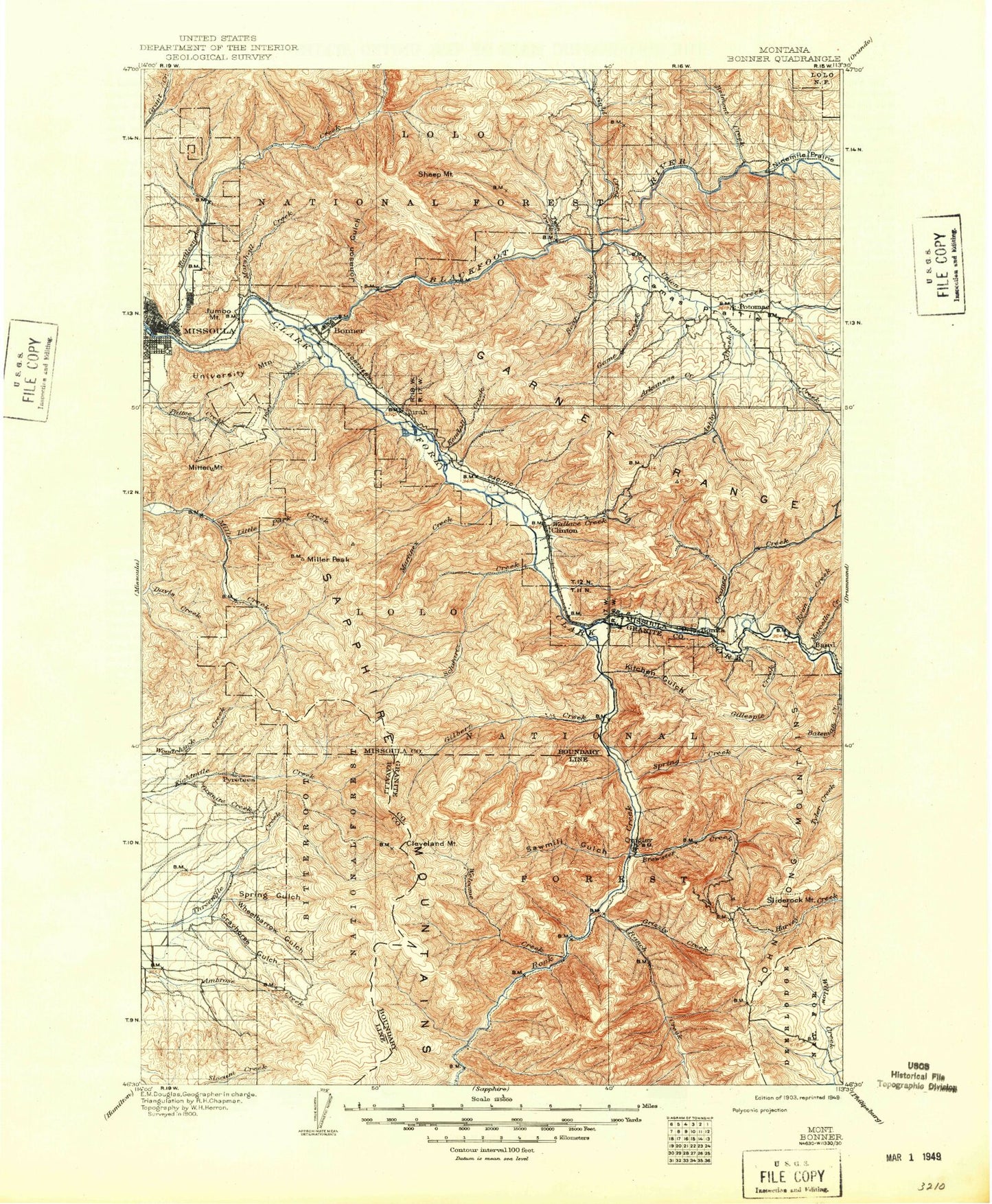
Historic 1903 Bonner Montana 30'x30' Topo Map
Couldn't load pickup availability
Historical USGS topographic map of Bonner in the state of Montana. Scale: 1:125000. Print size: 18" x 24"
This map was published in 1903 and is in the following counties: Granite, Missoula, Ravalli.
The map contains contour lines, roads, rivers, towns, streams, and lakes. Printed on high-quality waterproof paper with UV fade-resistant inks.
Contains the following named places: Ashby Creek, Linton Mine, Mineral Ridge, Smith Creek, West Fork Cramer Creek, Allen Creek, Alps Mine, Ammon Gulch, Anderson Park, Angevine Park Picnic Area, Apex Gulch, Arasta Creek, Argo Mine, Arkansas Creek, Ashby Creek, Avon Creek, Babcock Creek, Babcock Mountain, Baldy Mountain, Bandmann Flats, Bear Creek, Bear Gulch, Bear Gulch, Bear Run Creek, Beavertail Hill, Beavertail Tunnel, Beeskove Creek, Bellview Mine, Belmont Creek, Bidwell Gulch, Bitterroot Divide, Blixit Creek, Blue Point, Blue Slide, Blue Slide Campground, Bobcat Creek, Bonner, Bonner Junction, Bonner Mountain, Bonner Park, Brewster Creek, Buck Creek, Burnt Bridge Creek, Burnt Mountain, Butte Cabin Creek, Camas Creek, Camas Prairie, Campbell Park, Carron Creek, Chico Gulch, Chino Creek, Cinnabar Creek, Cinnamon Bear Creek, Cinnamon Bear Point, Cleveland Mine, Clinton, Clinton Irrigation District Canal, Colma Gulch, Colusa Gulch, Cooney Ridge, Corduroy Creek, Corona Gulch, Cow Creek, Cramer Creek, Crazy Canyon, Crystal Creek, Dagret Creek, Daigles Eddy, Dalles Creek, Danny O'Brien Gulch, Davis Point, Mount Dean Stone, Deer Creek, Diamond Mountain, Dirty Ike Creek, Dog Monument Draw, Donovan Creek, Drake Gulch, Dunnigan Gulch, East Fork Brewster Creek, East Fork Deer Creek, East Fork Grant Creek, East Fork Rattlesnake Creek, East Hill, East Missoula, East Twin Creek, Edelman Creek, Elk Draw, Elk Mountain, Elkhorn Creek, Feather Gulch, Ferret Creek, Fiddler Gulch, Flat Creek, Fourth of July Creek, Fraser Creek, Fresno Gulch, Game Creek, Gilbert Creek, Gillispie Creek, Goat Creek, Gold Creek, Gold Creek Guard Station, Golden Gulch, Golden Mountain, Goose Rock, Goose Rock Flat, Granite Creek, Gratton Gulch, Grayhorse Creek, Greenough Creek, Greenough Park, Grizzly Campground, Grizzly Creek, Hamm Gulch, Harrys Flat Campground, Harrys Gulch, Hellgate Canyon, Heyers Gulch, Hidden Treasure Mine, Highline Gulch, Holloman Creek, Howell Creek, Iris, Iris Point, Iris Point Trail, John Long Trail, Johnson Gulch, Johnsrud Park, Jumbo Mine, Mount Jumbo, Kallis Creek, Kendall Creek, Kitchen Gulch, Kiwanis Park, La Fray Creek, Laveck Creek, Leeper Gulch, Limestone Creek, Little Belmont Creek, Little Belmont Point, Little Park Creek, Lockwood Lake, Lockwood Point, Ione Gulch, Madison Park, Marcella Creek, Marco Flat Picnic Area, Marshall Canyon, Marshall Creek, Mason Gulch, Matt Gulch, McDermott Gulch, McFarland Gulch, McNamara, McQuarrie Spur, Mecca Gulch, Middle Fork Deer Creek, Middle Fork Swartz Creek, Miller Peak, Milltown, Milltown Dam, Missoula, Mitten Mountain, Mittower Gulch, Moccasin Creek, Moccasin Ridge, Moe Gulch, Morrison Peak, Nimrod Tunnels, Norman Creek, North Fork Brewster Creek, North Fork Eightmile Creek, North Fork Gilbert Creek, Northside Park, Oasis Gulch, Olson Peak, Otter Creek, Otters Hump Trail, Park Creek, Pat Gulch, Pattee Canyon, Pattee Canyon Picnic Area, Pawnee Gulch, Pilcher Creek, Piltzville, Pinegrove, Plant Creek, Potomac, Powers Creek, Quast Ditch, Quigley, Ranch Creek, Rattlesnake Creek, Ravenna, Red Rock, Red Rock Flat, Rickard Gulch, Rock Creek, Ryan Creek, Saint Lawrence Creek, Sawmill Gulch, Sawmill Gulch, Swartz Creek, Mount Sentinel, Sequoia Gulch, Sheep Creek, Sheep Flats, Sheep Mountain, Shoofly Meadows, Shylo Creek, Sliderock Mountain, Solomon Creek, Solomon Mountain, Solomon Ridge Trail, South Fork Gilbert Creek, Spartan Creek, Spink Point, Spooner Creek, Spring Creek, Spring Creek, Spring Gulch, Spring Gulch, Starvation Creek, Steves Pass, Sunflower Mountain, Tamarack Creek, Tamarack Gulch, Teton Gulch, Thibideau Rapids, Threemile Point, Tipperary Creek, Triangle Mine, Tule Gulch, Tunnel Lake, Turah