MyTopo
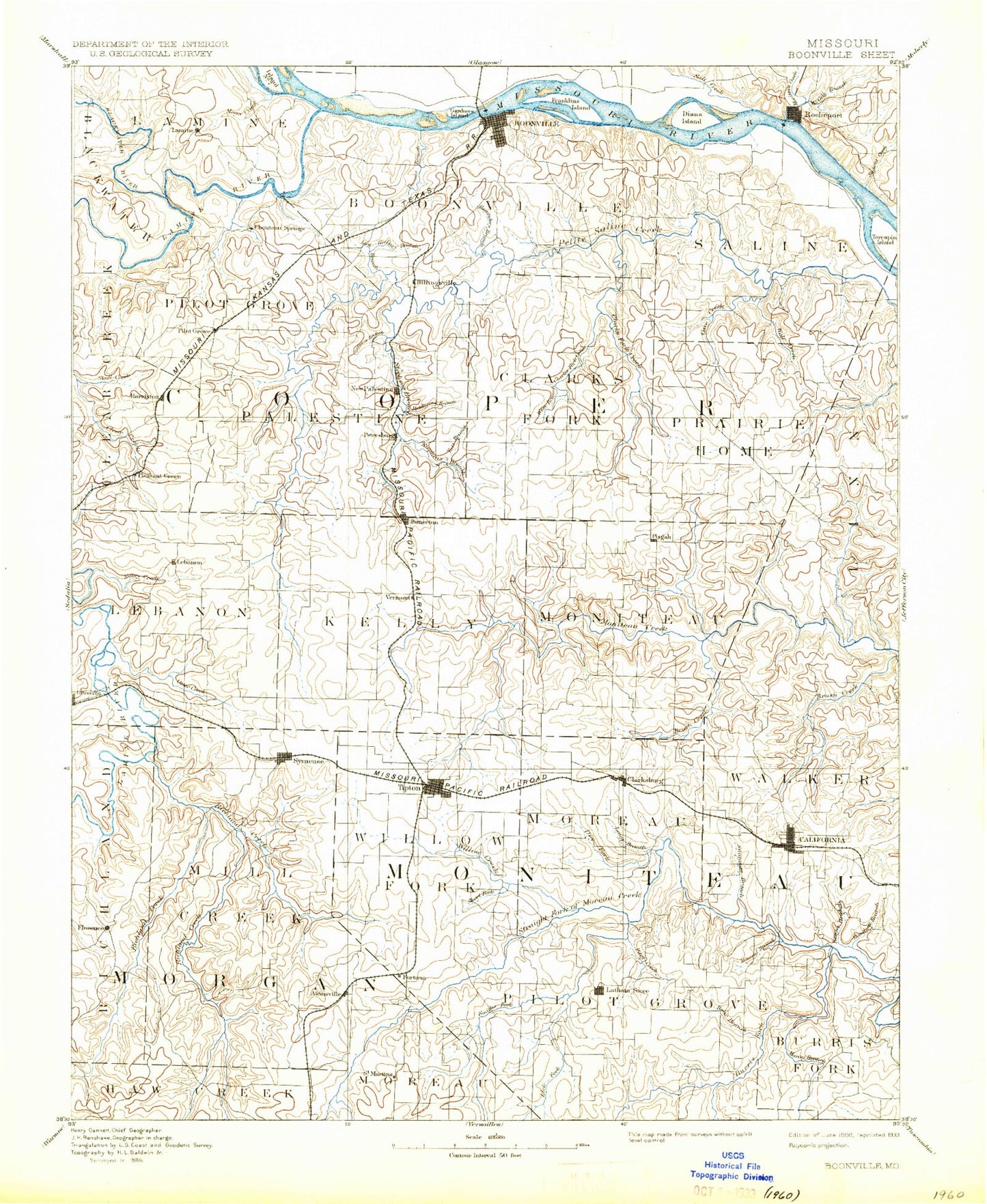
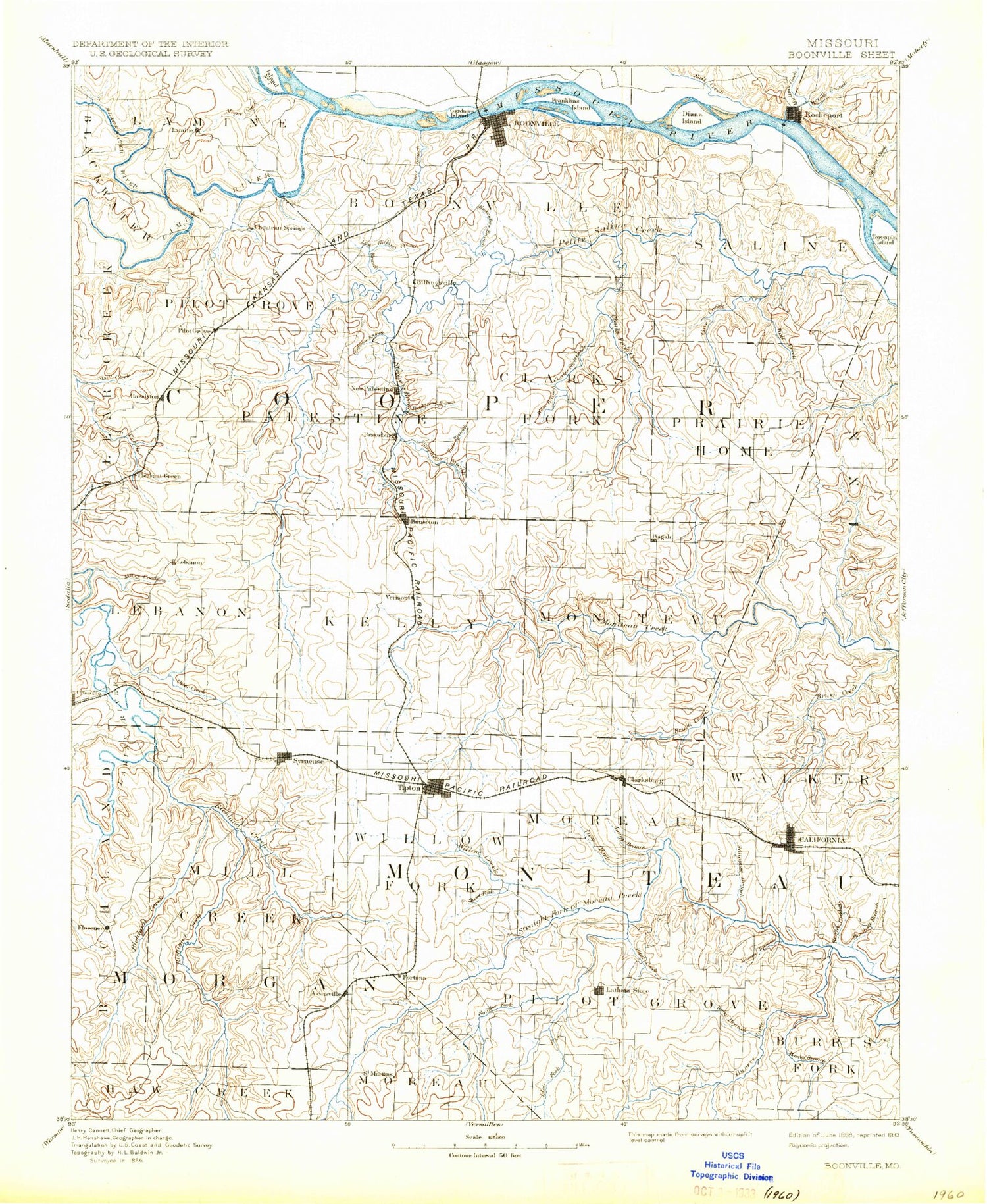
Historic 1888 Boonville Missouri 30'x30' Topo Map
Couldn't load pickup availability
Historical USGS topographic map of Boonville in the state of Missouri. Scale: 1:125000. Print size: 17" x 24"
This map was published in 1888 and is in the following counties: Boone, Cooper, Howard, Moniteau, Morgan.
The map contains contour lines, roads, rivers, towns, streams, and lakes. Printed on high-quality waterproof paper with UV fade-resistant inks.
Contains the following named places: Anderson Branch, Baslee Branch, Bear Branch, Bell Branch, Big Branch, Blackwater, Boonville, Brush Creek, Brushy Branch, Buck Branch, Bunceton, Cave Creek, Chouteau Branch, Chouteau Creek, Clarksburg, Coalbank Creek, Coon Creek, Culley Creek, Derbey Lake, Draffen Branch, Dry Fork, East Brush Creek, Flat Creek, Flat Creek, Fortuna, Franklin Island, Gabriel Creek, Gardner Island, Glensted, Gooseberry Hollow, Grassy Branch, Grassy Lake, Gump Branch, Hadley Branch, Hickory Branch, Honey Creek, Howard Creek, Howard Creek, Kelley Branch, Kelley Branch, Lamine, Lick Branch, Lilly Branch, Little Branch, Little Richland Creek, Lone Elm, Long Branch, Long Branch, Martin Branch, Martin Branch, Maxie Branch, McGill Branch, McNeal Branch, Messer Creek, Middle Richland Creek, Mineral Branch, Moniteau Creek, Moon Creek, Mount Vernon Branch, Murphy Creek, North Carolina School, Old Channel Salt Creek, Otter Creek, Panther Branch, Panther Creek, Pilot Grove, Pisgah, Pisgah Creek, Pleasant Green, Prairie Home, Ream Branch, Reno Hill, Richland Creek, Rocheport, Rocky Point School, Rupe Branch, Salt Branch, Salt Creek, Schaaf Creek, Scott Branch, Sinking Creek, Slaughterhouse Bend, Smiley Creek, Smith Creek, Speed, Spring Branch, Stephens Branch, Straight Fork, Taylor Branch, Thomas Branch, Tipton, Turkey Trot Creek, Tutt Branch, West Branch Clark Fork, West Brush Creek, West Fork Petite Saline Creek, Widel Lake, Willow Branch, Wilson Lake, Wolf Creek, Bartlett Creek, Bonne Femme Creek, Burger Creek, Burris Fork, Clark Fork, Cotton, Gooch Mill, Hutchison Branch, Kliever, Lick Creek, Marney Branch, Marshall Creek, New Lebanon, Overton, Pilot Branch, Skull Creek, Smith Branch, Willow Fork, Wooldridge, Blackwater River, Florence, Lamine River, Syracuse, Medlen Creek, Gartners Branch, Lick, Harriston, Brant, Corticelli, Cedron, Renfro, Aikinsville, Bellair, Billingsville, Chouteau Springs, Clarks Fork, Hoffman, Merna, Pleasant Grove, Prairie Home State Wildlife Area, West Central Loess Hills, Northern Ozarks, Kemper Golf Course, Latham, Short Fork, Railroad Lake, Cooper County, Moniteau County, Windmill Campground Dam, Southwest Dam Number 1, McCoy Number 1 Reservoir, Rolfling Lake Section 36 Dam, Rolfling Lake, Rolfling Lake Section 6 Dam, Number 226 Reservoir, Holtzclaw Lake Dam, Oswald Lake Dam, Trout Dam, Trout Lake, Stoelting Dam, Stoelting Lake, Schnuck Lake Dam, Smith Lake Dam, Lenz Lake Dam, Becker-Miller-Marcum Lake Dam, Zimmerman Lake Dam, Phillips Lake Dam, Fenical Lake Dam, Number 576 Dam, Number 577 Dam, Proctor Park Lake Dam, Elliott Lake Dam, R Elliott Lake, Number 742 Dam, Veulemans Lake Dam, Crews Lake Dam, Knipp Lake Dam, Porter Lake Dam, Robinsons Dam, Robinsons Lake, Windsor Place Number 2 Dam, Windsor Place Number 1 Dam, Friedrich Lake Dam, Friedrich Lake, McMenamy Lake Dam, Langkop Lake Dam, Schrader Lake Dam, Keane Lake Dam, California, Township of Boonville, Township of Clark Fork, Township of Clear Creek, Township of Kelly, Township of Lamine, Township of Lebanon, Township of North Moniteau, Township of Palestine, Township of Pilot Grove, Township of Prairie Home, Township of Saline, Township of South Moniteau, Township of Burris Fork, Township of Moreau, Township of Pilot Grove, Township of Walker, Township of Willow Fork, Township of Mill Creek, Township of Richland, Big Manitou Bluffs, Windsor Place, Lamine River Bend, Boonville Bends, De Bourgmont Access, Franklin Bend, Franklin Island Reach, Diana Bends, Rocheport Bends, Taylor's Landing Access, Overton Bottoms Conservation Area, City of Bunceton, City of California, City of Clarksburg, City of Blackwater, City of Boonville, City of Syracuse, City of Pilot Grove, City of Prairie Home, City of Rocheport, City of Tipton, Village of Windsor Place, Village of Wooldridge, Big Muddy National Fish and Wildlife Refuge