MyTopo
Historic 1935 Borah Peak Idaho 30'x30' Topo Map
Couldn't load pickup availability
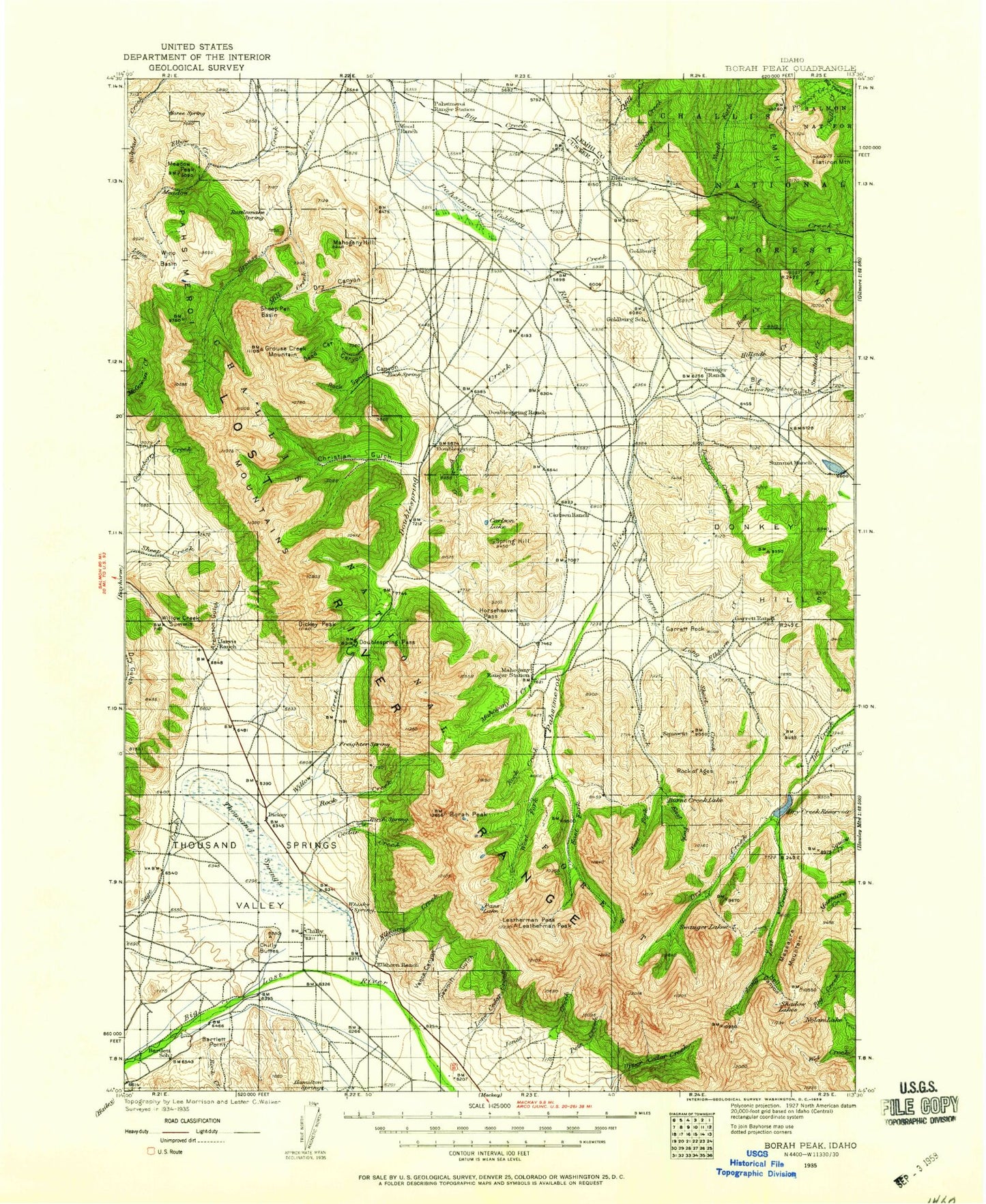
Historical USGS topographic map of Borah Peak in the state of Idaho. Scale: 1:125000. Print size: 18" x 24"
This map was published in 1935 and is in the following counties: Custer, Lemhi.
The map contains contour lines, roads, rivers, towns, streams, and lakes. Printed on high-quality waterproof paper with UV fade-resistant inks.
Contains the following named places: Rock of Ages, Leatherman Peak, Arentson Gulch, Baby Creek, Bartlett Creek, Bartlett Point, Bear Creek, Big Creek, Big Creek Peak, Big Gulch, Borah Peak, Buck Creek, Buck Creek, Burnt Creek, Burnt Creek Lake, Carlson Lake, Cayuse Canyon, Cedar Creek, Cedar Creek Bar, Chilly Canal, Christian Gulch, Climb Creek, Cooney Canyon, Dead Cat Canyon, Dickey, Dickey Peak, Ditch Creek, Donkey Creek, Donkey Hills, Doublespring Creek, Doublespring Pass, Doublespring Ranch, Dry Canyon, East Fork Burnt Creek, East Fork Pahsimeroi River, Elbow Creek, Elkhorn Creek, Elkhorn Creek, Elkhorn Ranch, Falls Creek, Flatiron Mountain, Garrett Rock, Goldburg Creek, Grant Creek, Grouse Creek Lake, Grouse Creek Mountain, Hell Canyon, Hillside Creek, Horseheaven Pass, Jones Creek, Leatherman Pass, Lone Cedar Creek, Long Creek, Long Lost Creek, Mahogany Creek, Mahogany Hill, Massacre Mountain, Meadow Peak, Mill Creek, Mill Creek, Mud Spring Canyon, Mulkey Gulch, Nolan Lake, North Fork Big Creek, Pahsimeroi Mountains, Pass Lake, Prospect Creek, Rock Creek, Rock Creek, Rock Creek, Rock Spring Canyon, Sage Creek, Sawmill Gulch, Shadow Lakes, Sheep Pen Basin, Short Creek, Snowslide Creek, South Fork Big Creek, Squaw Creek, Squawtit, Stinking Creek, Summit Ranch, Swauger Lakes, Talman Creek, Thousand Springs, Thousand Springs Creek, Thousand Springs Valley, Vance Canyon, West Fork Big Creek, West Fork Burnt Creek, West Fork Pahsimeroi River, Willow Creek, Willow Creek Summit, Wino Basin, Donaldson Peak, Earthquake Visitors Information Center, Upper Pahsimeroi Recreation Site, Dry Creek Reservoir, Barton Flats, Castle Peak, Chilly Buttes, Goldburg, Merriam Lake, Swensen Butte, Chilly, Mount Breitenbach, Spring Hill, Summit Reservoir, Big Creek Campground, Summit Dam, Wood Ranch, Big Lost River Upper Access Area, Quake Lake, Copper Lake, Borah Glacier