MyTopo
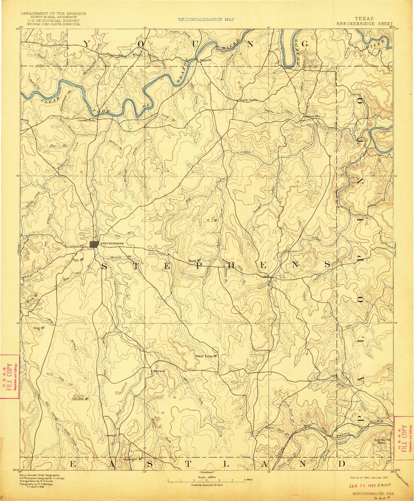
Historic 1890 Breckenridge Texas 30'x30' Topo Map
Couldn't load pickup availability
Historical USGS topographic map of Breckenridge in the state of Texas. Scale: 1:125000. Print size: 17" x 24"
This map was published in 1890 and is in the following counties: Eastland, Palo Pinto, Stephens, Throckmorton, Young.
The map contains contour lines, roads, rivers, towns, streams, and lakes. Printed on high-quality waterproof paper with UV fade-resistant inks.
Contains the following named places: Bald Mountain, Ball Mountain, Bass Island, Bear Hollow, Beaver Mountain, Bee Branch, Bee Branch Mountain, Bee Creek, Big Branch, Bills Creek, Bloomfield Branch, Bone Bend, Brad Branch, Breckenridge Oil Field, Brier Bend, Broadway Channel, Brown Branch, Brown Pen Mountain, Buck Mountain, Buffalo Branch, Bufford Creek, C J Mountain, Caddo Bay, Caddo Creek, Caudill Mountain, Cedar Spring Tank, Cemetery Point, Coal Branch, Coal Mountain, Conner Lake, Coon Mountain, Cottonwood Creek, Crooked Branch, Curry Oil Field, Lake Daniel, Davis Creek, Devils Reservation Mountain, Dillihunt Hollow, Donkey Mountain, Double mountain, Dry Branch, Dry Branch, Duff Branch, East Fork Bufford Creek, East Kings Creek, Eliasville, Elm Creek, Elm Creek, Evensville Peak, Finley Branch, Flat Rock Creek, Fluehearty Branch, Fox Hollow Creek, Gage Creek, Goat Island, Gunsolus Creek, Gore Mountain, Gourley Oil Field, Grand Lake, Gunsight Mountain, Hamilton Hollow, Hayrick Mountain, Hill Oil Field, Hitson Branch, Hitson Branch, Hog Mountain, Horse Branch, Huffstuttle Creek, Hughes Mountain, Humble Dam, Iles Oil Field, Jones Branch, La Casa Valley Boys Ranch, Lime Rock Mountain, Limestone gap, Little Caddo Creek, Little Cedar Creek, Live Oak Creek, Lone Star Lake, Long Bend, Long Branch, Long Hollow, Maloney Creek, Maxwell Mountain, McMillan Branch, Middle Fork Gunsolus Creek, Mud Spring Tank, Mulberry Creek, Lake Necessity, Norton Branch, O'Neal Oil Field, Palo Pinto Mountains, Peach Creek, Peacock Creek, Peveler Creek, Pickard Creek, Poor Bend, Possum Kingdom Lake, Possum Kingdom State Park, Post Oak Branch, Rocky Hollow, Round Mountain, Rush Branch, Russell Creek, Salem Bend, Sam Bass Hollow, Sandy Beach, Sandy Creek, Scotch Hollow, Shot Hollow, Six Shooter Creek, South Bills Creek, South Fork Gage Creek, Sow Branch, Spring Branch, Spy Mountain, Steal Easy Mountain, T P Lake, Texas Dam, Texawa Canyon, Tucker Lake, Turner Branch, Twin Lakes, Union Lake, Veale Creek, Wagon Timber Creek, Walker Branch, West Fork Bufford Creek, Yates Hill, Yellow Branch, Yellow Gap, Sink Creek, Sink Creek, Big Branch, Big Sandy Creek, Breckenridge, Cedar Creek, Cedar Creek, Cove Creek, East Fork Gunsolus Creek, East Sandy Creek, Givens Creek, Hubbard Creek, Iron Ore Creek, Kings Creek, Sandy Creek, Spring Canyon, West Fork Gunsolus Creek, Brad, Bullock, Caddo, Crystal Falls, Frankell, Gunsight, Harpersville, Ivan, La Casa, Necessity, South Hanlon, Wayland, Stephens County, Gibon Lake Dam, Gibson Lake, J S McDowell Lake Dam, J S McDowell Reservoir, Rogers Dam, Rogers Lake, Ohio Oil Company Lake Dam, Ohio Oil Company Reservoir, Kelly Lake Dam, Kelly Lake, H Graden Dye Dam, H Graden Dye Reservoir, J Dye Lake Dam, J Dye Lake, Texas Company Reservoir, Conner Lake Dam, Petroleum Corporation of Texas Dam, Petroleum Corporation of Texas Reservoir, T C Fambro Dam, T C Fambro Reservoir, Gonzales Creek Dam, Lake Necessity Dam, J M Frambo Lake Dam, J M Frambo Lake, Grand Lake Dam, Hubbard Creek Dam, Powers Dam, Powers Reservoir, Crystal Falls Dam, Crystal Falls Reservoir, Dooley Lake Dam, Dooley Lake, A A Atkins Lake Dam, A A Atkins Reservoir, Texas Company Lake Dam, Texas Company Reservoir, Stephens Company Water Company Lake Dam, Stephens Company Water Company Reservoir, Monroe Veal Dam, Tullos Lake, Union Lake Dam, Lester Clark Reservoir, Lake Tucker Dam, Double Gates Lake Dam, Double Gates Lake, Lone Star Lake Dam, Old Eureka Mill Reservoir Dam, Old Eureka Mill Reservoir, Scott Lake Dam, Scott Lake, Robbins Lake Dam, Robbins Lake, Petes Pride Lake Dam, Petes Pride Lake, Humble Lake Dam, Humble Lake, Glynn Wilson Dam, Glynn Wilson Lake, Henslee Lake Number 3 Dam, Henslee Lake Number 3, Carey Lake Dam, Carey Lake, Pitzer Lake Dam, Pitzer Lake, Taylor Hollow, Breckenridge North Division, Breckenridge South Division, Greyhound Stadium, Buckaroo Field, Joe K Boyce Park, Miller Park, Possum Kingdom State Park Trail, City of Breckenridge