
MyTopo
Historic 1895 Briceville Tennessee 30'x30' Topo Map
Couldn't load pickup availability
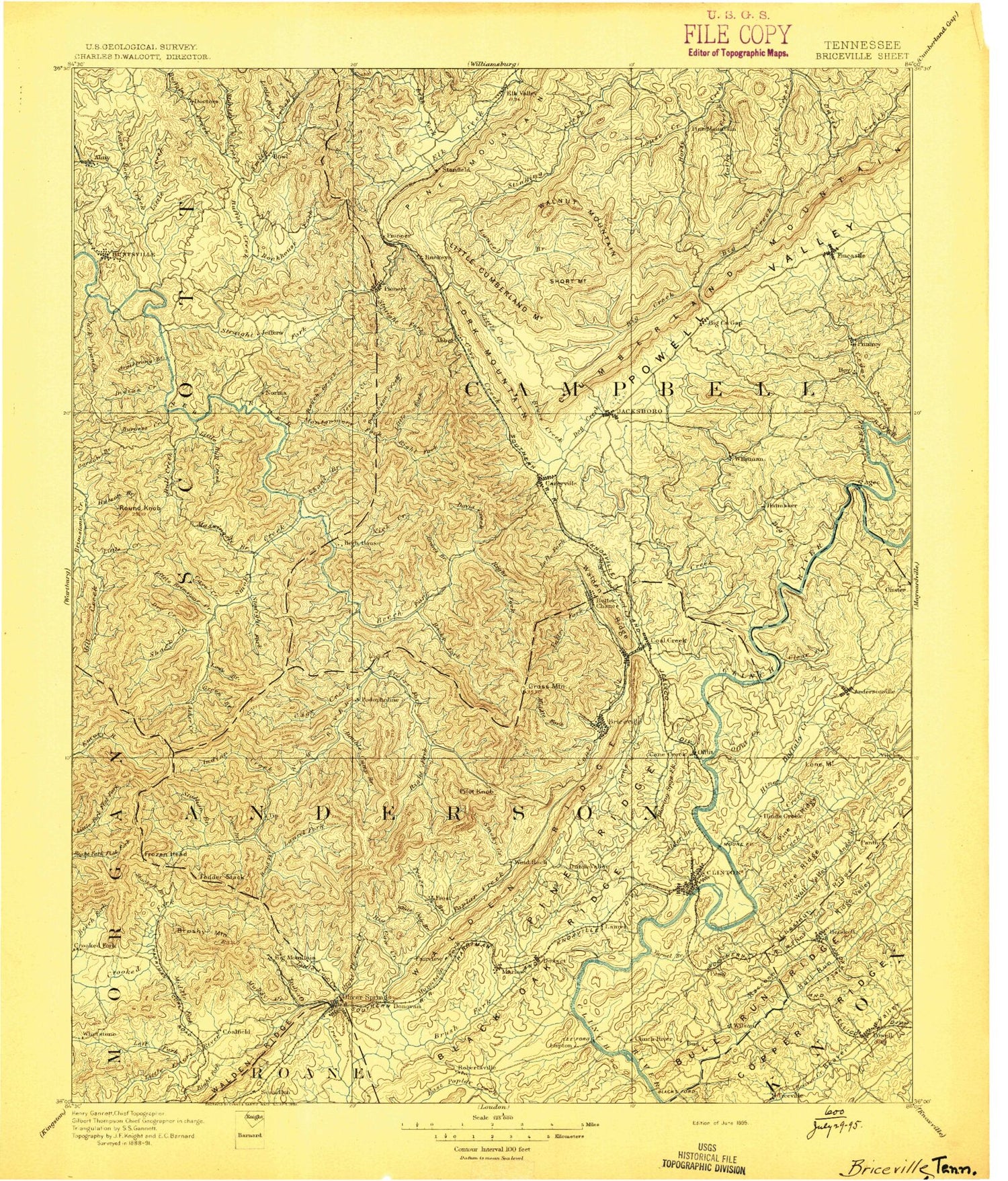
Historical USGS topographic map of Briceville in the state of Tennessee. Scale: 1:125000. Print size: 18" x 24"
This map was published in 1895 and is in the following counties: Anderson, Campbell, Knox, Morgan, Roane, Scott, Union.
The map contains contour lines, roads, rivers, towns, streams, and lakes. Printed on high-quality waterproof paper with UV fade-resistant inks.
Contains the following named places: Big Creek, Blackoak Ridge, Blazer Branch, Brushy Valley, Buffalo Mountain, Buffalo Mountain, Chestnut Ridge, Davis Creek, Flint Ridge, Fork Mountain, Hickory Valley, Jackson Branch, Jordan Hollow, Lone Mountain, Old Mac Mountain, Pine Ridge, Powell Valley, Rough Ridge, Shea, Shelton Branch, Sherwood Estates, Shoat Lick Hollow, Shoffner Branch, Short Mountain, Shown Hollow, Shug Mountain, Silas Hollow, Silcox Mountain, Simpson Branch, Skull Branch, Slatestone Hollow, Slick Rock Branch, Slick Rock Branch, Slickrock Hollow, Slide Hollow, Smith Cove, Smoky Creek, Smoky Mountain, Snake Den Branch, Solomon Hollow, South Clinton, South Fork Geise Creek, South Fork Montgomery Fork, Sparkman Hollow, Spice Lick Bottoms, Spicewood Hollow, Split Chestnut Hollow, Spring Branch, Spring Hill Hollow, Spring Rockhouse Branch, Sprucepine Branch, Squire Knob, Stallion Branch, Stallion Mountain, Stanley Creek, Steamboat Rock, Stell Branch, Stephens, Sterling Siding, Steve Ridge, Still Creek, Stillhouse Hollow, Stillhouse Hollow, Stillhouse Hollow, Stillhouse Hollow, Stockstill Creek, Stokes Hollow, Stone Coal Branch, Stony Flat, Straight Fork, Straight Fork, Straight Mountain, Strong Hollow, Su-Dennie Dock, Suck Hollow, Sugar Hollow, Sugar Hollow, Sugar Tree Gap, Sugarcamp Branch, Sugarcamp Branch, Sugarcamp Branch, Sutton Hollow, Sutton Ridge, Swamp Branch, Sweet Gum Flats, Sweeten Spring Hollow, Tackett Branch, Tanbark Knob, Taylor Creek, Tennessee Hollow, Terry Branch, Terry Creek, Terry Hollow, The Cove, The Flag Pole, The Garden Spot, The Horse Tie, The Lone, Thompson Creek, Three Forks Hollow, Thunderstruck Knob, Tidwell Hollow, Toddy Mountain, Tom Hollow, Tram Road Branch, Tram Road Hollow, Tram Road Hollow, Tunnel Hollow, Turkey Branch, Turkey Hollow, Turkey Ridge, Turkeypen Ridge, Turley Branch, Turley Mountain, Twin Cove, Union, Union Valley, Upper Fork, Ursery Branch, Valley View Heights, Vasper, Vasper Hollow, View Tree Knob, Vowell Mountain, Wagon Rock, Walden Hollow, Walnut Cove, Walnut Knob, Walnut Mountain, Ward Branch, Ward Hollow, Wash Ridge, Washington Heights, Water Branch Hollow, Waterfall Branch, Webb Branch, Welch Camp, Wells Branch, Wesley Gap, West Branch Bull Run Creek, West Prong Davids Creek, West Prong Nicks Creek, Westwood Estates, Whetstone Branch, Whetstone Mountain, Whitaker Hollow, White Gap, White Pine Point, White Schoolhouse Corners, Whitman Hollow, Wild Sow Branch, Williams Branch, Williams Creek, Willoughby Hollow, Willow Springs Gap, Wilson Branch, Wilson Hollow, Windrock Fields, Windrock Mountain, Winona, Wolf Branch, Wolf Branch, Wolf Gap, Wolf Hollow, Wolf Pen Hollow, Wolf Ridge, Wolf Ridge, Wolfpen Branch, Wolfpen Branch, Wolfpen Hollow, Woodson Gap, Worthington Branch, Wright Creek, Y Hollow, Yarnell Gap, Yellow Branch, York Branch, Zeb Mountain, Zeek Ridge, Haw Ridge Park, Adams Hollow, Adkins Branch, Adkins Branch, Adkins Mountain, Airshaft Hollow, Airshaft Hollow, Alder Branch, Alex Branch, Allen Creek, Allen Hollow, American Knob, Anderson Branch, Anderson County Park, Anderson Mountain, Andy Branch, Andy Ridge, Arch Hollow, Arch Mountain, Armstrong Branch, Ash Log Gap, Ash Log Mountain, Asher Branch, Asher Fork, Aulton Branch, Back Spur, Backbone Hollow, Backbone Ridge, Baird Hollow, Bald Knob, Bald Knob, Bald Knob Hollow, Bald Knob Hollow, Barb Hollow, Barkcamp Creek, Barley Creek, Barley Mouth Branch, Bear Branch, Bear Branch, Bear Hollow, Bear Knob, Bear Wallow Branch, Beartree Hollow, Bearwallow Branch, Bearwallow Creek, Bearwallow Hollow, Bee Branch, Bethel, Big Branch, Big Branch, Big Bruce Ridge, Big Butte, Big Cove Branch, Big Creek Gap, Big Fork Ridge, Big Fork Ridge, Big Hollow


