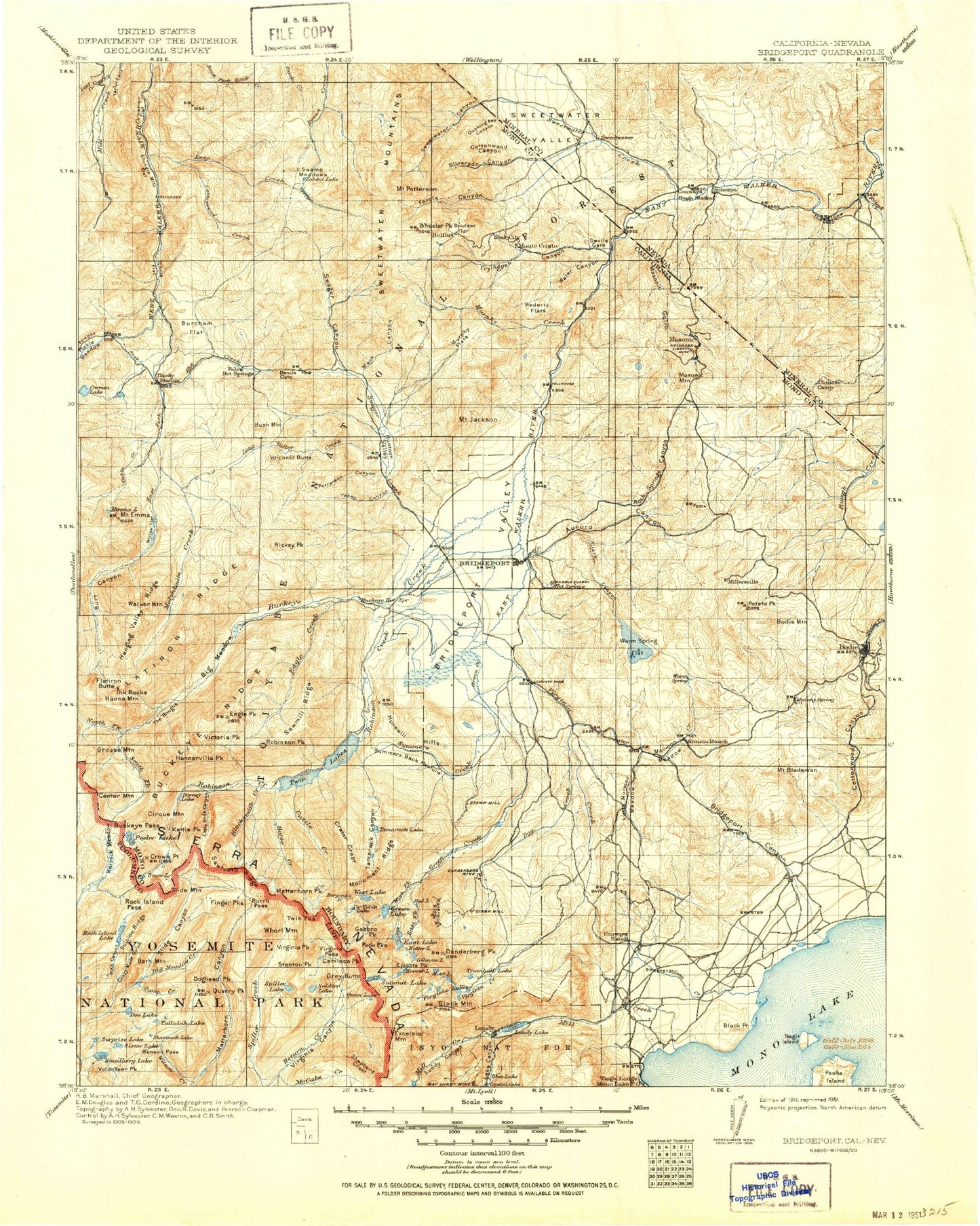
MyTopo
Historic 1911 Bridgeport California 30'x30' Topo Map
Couldn't load pickup availability
Historical USGS topographic map of Bridgeport in the state of California. Scale: 1:125000. Print size: 17" x 24"
This map was published in 1911 and is in the following counties: Lyon, Mineral, Mono, Tuolumne.
The map contains contour lines, roads, rivers, towns, streams, and lakes. Printed on high-quality waterproof paper with UV fade-resistant inks.
Contains the following named places: Barney Lake, Mount Biedeman, Big Meadow, Blacksmith Creek, Bodie Bluff, Boone Canyon, Bridgeport Ranger Station, Buckeye Creek, Buckeye Ridge, Bull Creek, Bush Mountain, By-Day Creek, Chemung Mine, Cinnabar Canyon, Cirque Mountain, Clark Canyon, Clearwater Creek, Cottonwood Canyon, Cottonwood Canyon, Cowcamp Creek, Deep Wash Canyon, Devils Gate, Devils Gate, Doe Canyon, Dry Creek, Dynamo Pond, Eagle Creek, Eagle Peak, Emma Lake, Feridell Ranch, Ferris Canyon, Finger Peaks, Flatiron Ridge, Fryingpan Canyon, Fryingpan Creek, Green Creek, Grouse Mountain, Hanging Valley Ridge, Hardy Station, Harvey Creek, Honeymoon Flat Campground, Hot Creek, Hunewill Hills, Hunewill Ranch, Huntoon Camp, Huntoon Creek, Ice Lake, Ink Rocks, Mount Jackson, Junction Creek, Junction Reservoir, Kettle Peak, Little Bodie Mine, Little Fryingpan Canyon, Little Long Valley, Little Mormon Meadow, Little Walker Cowcamp, Locomotive Point, Log Cabin Creek, Long Valley, Long Valley Creek, Long Valley Ponds, Mahogany Ridge, Maltby Lake, Masonic Mountain, McMillan Cabin, McMillan Lake, Milk Ranch Canyon, Montague Mine, Monte Cristo, Mormon Meadow, Mud Springs Canyon, Murphy Flat, New York Hill, Paramount Mine, Patterson Canyon, Perrini Mine, Pimentel Meadows, Pittsburg Liberty Mine, Point Ranch, Potato Peak, Quaking Asp Canyon, Rainbow Point, Red Cloud Mine, Rickey Cabin, Rickey Peak, Robinson Creek Campground, Robinson Peak, Rock Island Pass, Rock Springs Canyon, Rough Creek, Sario Canyon, Sario Ranch, Sawmill Creek, Silverado Canyon, Sister Lake, Huntoon Valley, Masonic Gulch, New Range, Red Wash Creek, Snow Lake, Star City, Stockade Flat, Success Mine, Sugarloaf, Tamarack Lake, Tamarack Mine, The Cleaver, The Slide, Tule Lake, Twin Lakes, Twin Lakes Campground, Upper Summers Meadows, Victoria Peak, Volcanic Butte, Walker Mountain, Walters Canyon, Water Canyon, Wedertz Flat, Wheeler Flat, Willow Flat, Yaney Canyon, Sweetwater Mountains, Bodie State Historic Park, Lower Summers Meadows, Hot Springs Canyon, Murphy Pond, Serita Mine, Rock Canyon, Horsetail Falls, Little Lake, Mule Pass, Robinson Lakes, Return Lake, Willow Springs, Buckeye Campground, Paho Campground, Sawmill Campground, Twin Lakes Campground, Trumbull Lake Campground, Matterhorn Peak, Wheeler Creek, Cameron Canyon, Cattle Creek, Crown Lake, Crown Point, Deep Canyon, Glacier Lake, Hanna Mountain, Lake Helen, Hunewill Peak, Labrosse Creek, Little Slide Canyon, Molybdenite Creek, Sawmill Ridge, Slide Canyon, Bridgeport Valley, Burt Canyon, Robinson Creek, South Fork Buckeye Creek, Summers Creek, Doe Lake, Doghead Peak, Quarry Peak, Sawtooth Ridge, Shamrock Lake, Smedberg Lake, Lower Summers Meadows, Suicide Ridge, Surprise Lake, Tallulah Lake, Big Alkali, Bridgeport Reservoir, Buckeye Pass, Burro Pass, Camp Creek, Center Mountain, Crazy Mule Gulch, Kerrick Meadow, Rock Island Lake, Virginia Peak, Volunteer Peak, Whorl Mountain, Wilson Creek, Angelo Mission Mine, Atastra Creek, Avalanche Lake, Bacon Gulch, Bath Mountain, Benson Pass, Bergona Lake, Big Meadow Creek, Black Mountain, Black Point, Blue Lake, Blue Lake, Bootles Canyon, Boulder Flat, Bridgeport Canyon, Burcham Creek, Burcham Flat, Burro Lake, Camiaca Peak, China Garden, Chris Flat, Conway Ranch, Conway Summit, Cooney Lake, Copper Mountain, Cottonwood Creek, Cottonwood Creek Meadows, Crater Crest, Crystal Lake, Danburg Beach, Dechambeau Creek, Dechambeau Ranch, Deep Creek, Deep Creek Mine, Deer Creek, Dome Hill, Driveway Creek, Dunderberg Creek, Dunderberg Peak, East Fork Desert Creek, East Fork Green Creek, East Fork Swauger Creek, East Lake, Excelsior Mountain, Flatiron Butte, Lake Frances, Frederick Mine, Frog Lakes, Gabbro Peak, Gilman Lake, Glenberry Lake, Glines Canyon