MyTopo
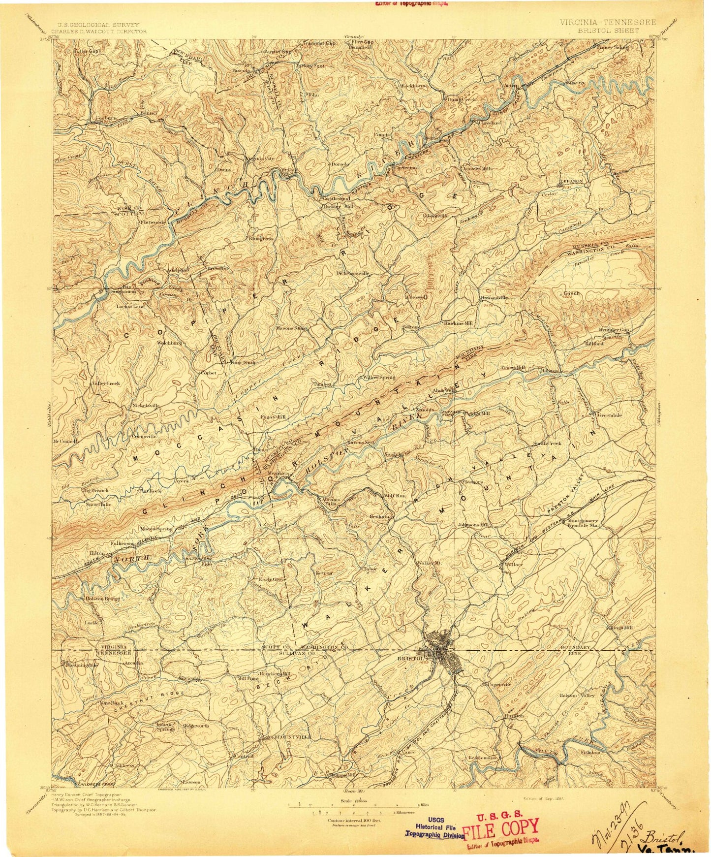
Historic 1897 Bristol Virginia 30'x30' Topo Map
Couldn't load pickup availability
Historical USGS topographic map of Bristol in the state of Virginia. Scale: 1:125000. Print size: 17" x 24"
This map was published in 1897 and is in the following counties: Bristol (city), Carter, Dickenson, Russell, Scott, Sullivan, Washington, Wise.
The map contains contour lines, roads, rivers, towns, streams, and lakes. Printed on high-quality waterproof paper with UV fade-resistant inks.
Contains the following named places: Akard Ridge, Clark Branch, Hicks Branch, Jackson Hollow, Back Creek, Deck Ridge, South Holston Lake, Steele Creek, Thomas Creek, Nicely Branch, Cove Creek, Ketron Branch, Mays Branch, Abrams Creek, Abrams Falls, Akard Ridge, Alvy Creek, Artrip, Austin Gap, Back Valley, Baker Hollow, Baker Hollow, Bakers Ridge, Bald Alley Bluff, Bear Wallow Hollow, Beaver Creek Reservoir, Bee Branch, Bee Branch, Bellamy Hollow, Bent Hole, Big Branch, Big Branch, Big Bull Tunnel, Big Cedar Creek, Big Falls, Big Jack Ridge, Big Spring Branch, Black Hollow, Blue Springs Branch, Booher Ridge, Boozy Creek, Boyd Hollow, Breezers Branch, Brickyard Gap, Bright Hollow, Broad Hollow, Browder Hollow, Brushy Ridge, Burgess Creek, Buzzard Roost Hollow, Caledonia Hollow, Callahan Spur, Caney Valley, Carr Creek, Carterton, Castle Run, Castle Siding, Cave Spring Hollow, Champ Branch, Chaney Creek, Chaney Hollow, Childers Hollow, Christy Cliffs, Cigarette Hollow, Clear Creek, Cleveland, Clover Field, Cole Hollow, Combs Valley, Lake Copper, Coulwood, Countiss Ridge, Counts, Cove Ridge, Cowpen Branch, Craigen Tunnel, Crooked Branch, Curley Hollow, Dante, Dark Hollow, Dean Branch, Detroit Cove, Dickey Mountain, Dilly Branch, Dismal Ridge, Divide Branch, Dorton Hollow, Dowell Branch, Dowell Gap, Drake Branch, Driftwood Creek, Dry Branch, Dry Fork, Dry Run, Dry Run Bend, Duff Knob, Dumps Creek, Dungeon Hollow, Dwina Hollow, Dwina Station, Eagle Nest Branch, East Fork Cove Creek, East Fork Roberts Creek, Eddington Gap, Evergreen Hills, Flat Top Ridge, Fleenor Branch, Flint Gap, Foley Gap, Fork Hollow, Fork Ridge, Fowlers Branch, Fraley Hollow, Fugate Gap, Gant Branch, Gaspard Creek, Gate Ridge, Glade Hollow, Good Branch, Goose Creek, Gose Hollow, Gouldman Branch, Gouldman Hollow, Granny Branch, Grassy Branch, Grassy Creek, Gravel Lick Creek, Grindstone Branch, Grindstone Branch, Grindstone Hollow, Grisby Hollow, Grizzles Branch, Hall Hollow, Hamilton Gap, Hamilton Gap, Hamlin Branch, Hardy Hollow, Harkleroad Hollow, Haskell Branch, Hasn Hollow, Kendrick Hollow, Hensley Hollow, Hiltons, Hiltons Creek, Hiltons Gap, Holbrook Tunnel, Holston River Mill, Honey Branch, Honey Branch, Honeycomb Branch, Hooper Ridge, Hop Hollow, Hurricane Fork, Indian Creek, Ivy Ridge, Jericho Hollow, Jessee Hollow, Jett Gap, Kilgore Creek, Kimberland Hollow, King Ridge, Kiser Bend, Krimmel Creek, Lark Branch, Laurel Branch, Laurel Branch, Laurel Branch, Lawsons Store, Left Fork Lick Creek, Leonard Hollow, Lick Branch, Lick Branch, Lick Creek, Lick Skillet Hollow, Little Bull Tunnel, Little Copper Creek, Little Creek, Little Duck Branch, Little Valley, Little Wolf Run, Livingston Creek, Lost Valley, Low Gap, Low Gap, Lower Cave Ridge, Maize Hollow, Max Hollow, McCall Gap, McGuire Hollow, Meade Branch, Meade Branch, Meade Creek, Meadows Branch, Meetinghouse Gap, Middle Cave Ridge, Mill Creek, Mill Creek, Millstone Branch, Minton Hollow, Moll Creek, Mollie Hollow, Monk Branch, Moses Branch, Mountain Creek, Muddy Branch, Muddy Branch, Muddy Branch, Muddy Hollow, Muddy Hollow, Muddy Spring Hollow, Mullins Hollow, Mullins Ridge, Nancy Ridge, Negro Hollow, Nordyke Creek, Osborne Hollow, Otter House Bluff, Pennus Hollow, Pinnacle, Porter Hollow, Possum Branch, Possum Hollow, Possum Hollow, Possum Hollow, Preston Hills, Price Gap, Pucketts Hole, Pullon Hollow, Pullontown, Pumplog Hollow, Raccon Branch, Raccoon Valley, Rattle Creek, Red Oak Ridge, Reeds Valley, Ridgeway Hollow