MyTopo
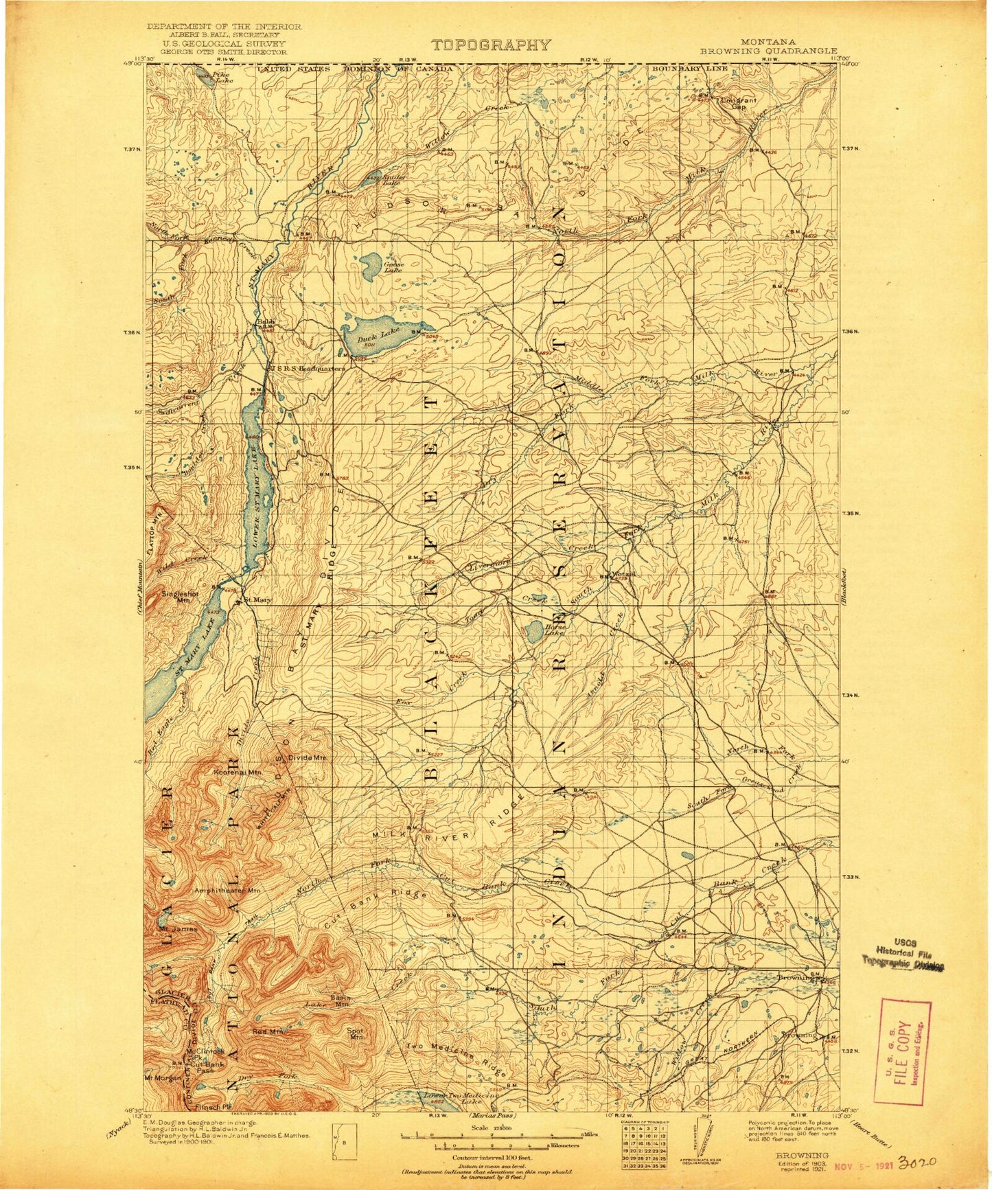
Historic 1903 Browning Montana 30'x30' Topo Map
Couldn't load pickup availability
Historical USGS topographic map of Browning in the state of Montana. Scale: 1:125000. Print size: 17" x 24"
This map was published in 1903 and is in the following counties: Flathead, Glacier.
The map contains contour lines, roads, rivers, towns, streams, and lakes. Printed on high-quality waterproof paper with UV fade-resistant inks.
Contains the following named places: Amphitheater Mountain, Arnoux Creek, Atlantic Creek, Atlantic Falls, Bad Marriage Mountain, Basin Mountain, Beaver Slide, Blackfeet Agency, Boulder Creek, Boundary Creek, Boundary Trail, Boy Lake, Browning Station, Burd Coulee, Camp Nine, Chewing Blackbones Campground, Crusher Hill, Curly Bear Mountain, Cut Bank Campground, Cut Bank Greasewood Canal, Cut Bank Pass, Cut Bank Pass Trail, Cut Bank Ranger Station, Cut Bank Ridge, Devils Slide, Divide Creek, Divide Mountain, Dry Fork Milk River, Dry Fork Trail, Dubray Coulee, Duck Lake, Eagle Plume Mountain, Emigrant Gap, Flatton Lake, Fox Creek, Freezeout Flat, Goose Lake, Greasewood Flat, Hall Coulee, Hidden Lake, Hoodoo Hill, Horse Lake, Houseman Hill, Hungry Horse Flat, Mount James, Josephine Lake, Kakitos Mountain, Katoya Lake, Kennedy Creek, Kiowa, Kupunkamint Mountain, Lake Creek, Livermore Creek, Lonely Lakes, Looking Glass Hill, Lower Saint Mary Lake, Mackinaw Bay, Mad Wolf Mountain, Madman Coulee, Malmstrom Air Force Base Recreation Area, McClintock Peak, Medicine Grizzly Lake, Medicine Grizzly Peak, Medicine Grizzly Trail, Medicine Owl Lake, Medicine Owl Peak, Middle Fork Greasewood Creek, Middle Fork Milk River, Milk River Ridge, Mount Morgan, Morning Star Lake, Murphy Coulee, Naoi Point, Napi Rock, North Fork Cut Bank Creek, Old Channel Middle Fork Milk River, Oldman Lake, Otatso Creek, Peterson Coulee, Port of Piegan, Pike Lake, Pine Ridge, Pitamakan Lake, Pitamakan Pass, Red Blanket Butte, Red Eagle Creek, Red Eagle Trail, Red Mountain, Running Crane Lake, Saint Mary, Saint Mary Campground, Saint Mary Canal, Saint Mary Lake, Saint Mary Ridge, Sand Rock Coulee, Seven Winds of the Lake, Singleshot Mountain, Sky Lake, South Fork Cut Bank Creek, South Fork Milk River, Spider Lake, Spot Mountain, Spring Coulee, Hagerty Creek, Pikuni Flat, Starr School, Starr School Flat, Swiftcurrent Creek, The Basin, Thunderbird Island, Toad Creek, Toad Lake, Twin Buttes, Two Dog Creek, Two Dog Flats, Two Medicine Ridge, Wetzel, White Calf Mountain, Wild Creek, Young Man Lake, Lower Two Medicine Lake, Pitamakan Pass Trail, Two Medicine Creek, Staples Dam, Lower Two Medicine Lake, Rossie the Fake Dam, Spider Lake Dam, Pistol Bullet Dam, Babb, Browning, Durham, Star, Columbia Grain Incorporated Elevator, Duck Lake Campground, Sleeping Wolf Campground, Leanin Tree Campground, Two Sisters Campground, Saint Mary Triple Divide Campground, Chief Mountain Junction, Aspenwood Camp, Johnsons Campground, Blackfeet Nation Historical Marker, Davis Coulee, Cow Creek, Freeze Out Creek, Old Agency 1880-1894 Historical Marker, North Browning, South Browning, Town of Browning