MyTopo
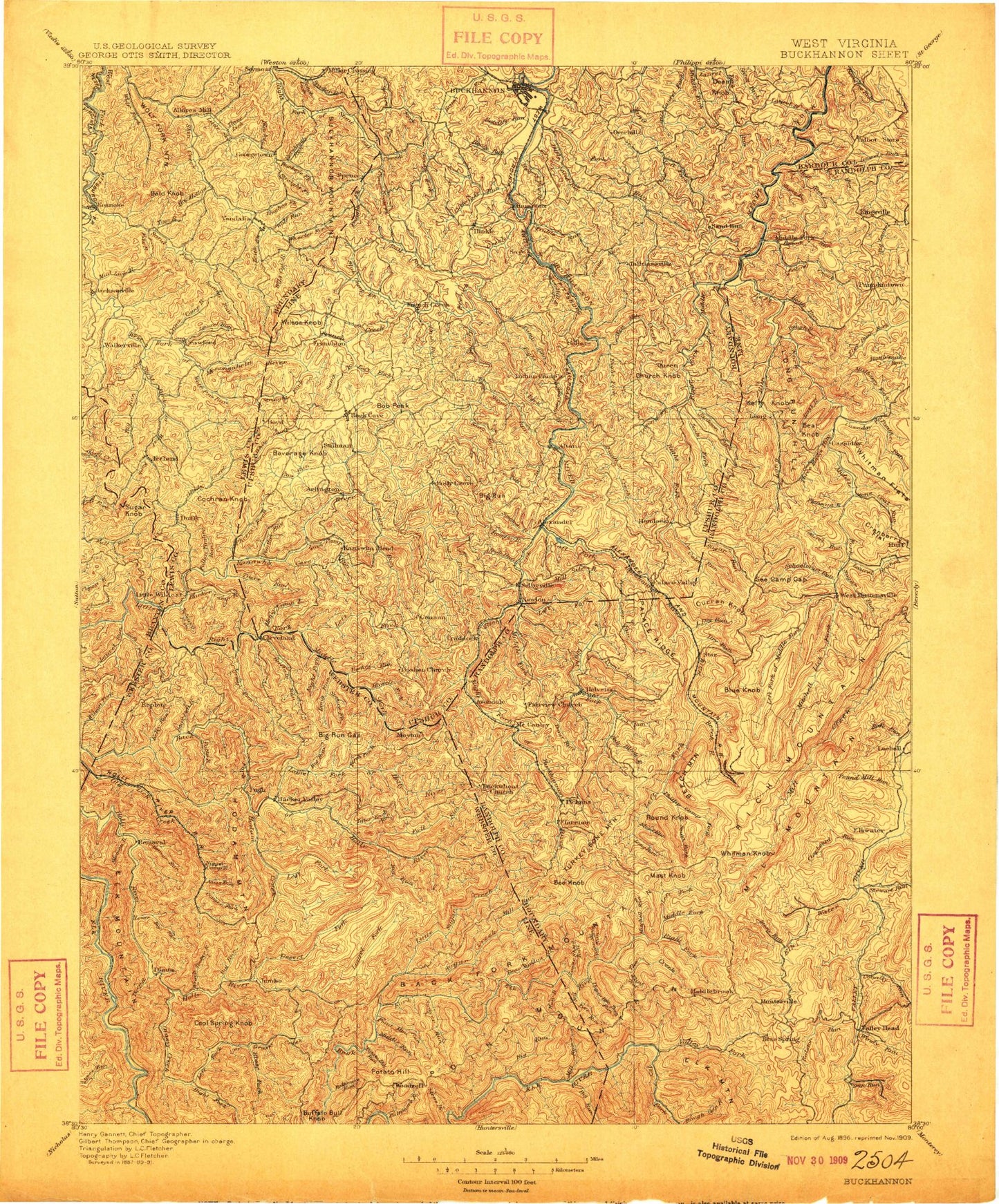
Historic 1896 Buckhannon West Virginia 30'x30' Topo Map
Couldn't load pickup availability
Historical USGS topographic map of Buckhannon in the state of West Virginia. Scale: 1:125000. Print size: 17" x 24"
This map was published in 1896 and is in the following counties: Barbour, Braxton, Lewis, Randolph, Upshur, Webster.
The map contains contour lines, roads, rivers, towns, streams, and lakes. Printed on high-quality waterproof paper with UV fade-resistant inks.
Contains the following named places: Aaron Run, Abb Run, Abrams Run, Alec Run, Amos Fork, Amos Fork, Anderson Camp Run, Andys Run, Aquilla Run, Arlington, Ash Camp, Bailey Ridge Community Center, Bald Knob, Baltimore Run, Barrenshe Hollow, Bear Hollow, Bear Knob, Bear Run, Bear Run, Bear Run, Bear Run, Bearcamp Run, Beaver Run, Beaver Run, Bee Knob, Bee Run, Beech Fork, Beech Mountain, Beech Run, Beechlick Run, Bennett Run, Bens Flats, Bens Run, Big Knob, Big Lick Fork, Big Lick Run, Big Run, Big Run, Big Run, Big Run, Big Run, Big Run, Big Run, Big Run Gap, Big Run Knob, Birch Fork, Birchpen Run, Blacklick Run, Blacklick Run, Blaze Fork, Blaze Fork, Brook Run, Brush Run, Brushlick Run, Brushy Fork, Buckhannon, Buffalo Run, Bull Run, Burnt Bridge, Buttonwood Run, Camden Hollow, Camp Mahoneqan, Canoe Run, Cap Run, Carlo Run, Carrion Run, Carter, Cave Run, Charles Run, Cherry Fork, Cherry Root Run, Chestnut Flats, Cleveland, Coal Hollow, Coalbank Run, Cochran Knob, Conrad Fork, Cougar Fork, Courthouse Rock, Cow Run, Cranberry Flat, Crane Camp Run, Crislip Run, Crooked Fork, Crooked Run, Crooked Run, Crooked Run, Cub Run, Curtis Run, Cutright Run, Deep Run, Desert Fork, Devil Fork, Devil Run, Devils Darning Needle, Dry Run, Dry Run, Dunkin Run, Easy Run, Enoch Run, Evergreen, Ezra Run, Fall Run, Fall Run, Fall Run, Fall Run, Fallen Timber Run, Fink Run, Fisher Run, Fisher Run, Fitz Run, Flat Run, Flatwoods Run, Fort Pickens Monument, French Creek, French Creek Game Farm, Frenchton, Getout Run, Glady Creek, Glady Fork, Glady Fork, Goshen, Grand Camp Run, Grandaddy Run, Grassy Creek, Grassy Creek, Grassy Run, Gravel Run, Green Hill, Grub Hollow, Guardian, Gum Run, Hacker Camp Run, Hacker Lick Run, Hacker Valley, Hanging Rock, Hartridge, Heaston Ridge, Hell Run, Helvetia, Herods Run, Hershman Run, Hickory Flat Run, Hicks Ridge, Hicks Run, Hierr Lick Run, High Knob, High Rock Trail, Highbank Run, Hinkleville, Hodam Creek, Hodam Mountain, Hog Hollow, Holly River State Park, Hollybush Run, Honey Camp Run, Hooker Run, Hooppole Run, Stonewall Jackson Lake Wildlife Management Area, Howell Fork, Hughes Fork, Ice Hollow, Indian Camp Run, Jackson Fork, Jawbone Run, Jenks Fork, Jerry Run, Joes Run, Johns Run, Jumbo, Kanawha Run, Keith Fork, Kelly Run, Kettle Run, Kittle Run, Laurel Creek, Laurel Fork, Laurel Fork, Laurel Fork, Laurel Fork, Laurel Run, Laurel Run, Laurel Run, Laurel Run, Laurel Run, Laurel Run, Laurel Run, Laurel Run, Laurel Run, Laurel Run, Laurel Run, Leatherbark Run, Leatherwood Run, Left Fork French Creek, Left Fork Laurel Fork, Left Fork Little Sand Run, Left Fork Right Fork Little Kanawha River, Left Fork Sand Run, Lick Run, Lick Run, Lick Run, Linger Run, Little Brush Run, Little Grassy Creek, Little Laurel Run, Little Laurel Run, Little Sand Run, Little Skin Creek, Little Wildcat Run, Log Hollow Run, Long, Long Run, Long Run, Long Run, Loop, Lost Run, Lower Aaron Run, Lower Big Run, Lynn Camp Run, Mader Run, Marsh Fork, McChord Run, Middle Fork Laurel Fork, Middle Fork Laurel Fork Sand Run, Middle Fork Right Fork Buckhannon River, Middle Run, Middle Run, Miller Creek, Millsite Run, Millstone Run, Millstone Run, Morgan Camp Run, Morgan Run, Moss Knob, Mudlick Run, Mudlick Run