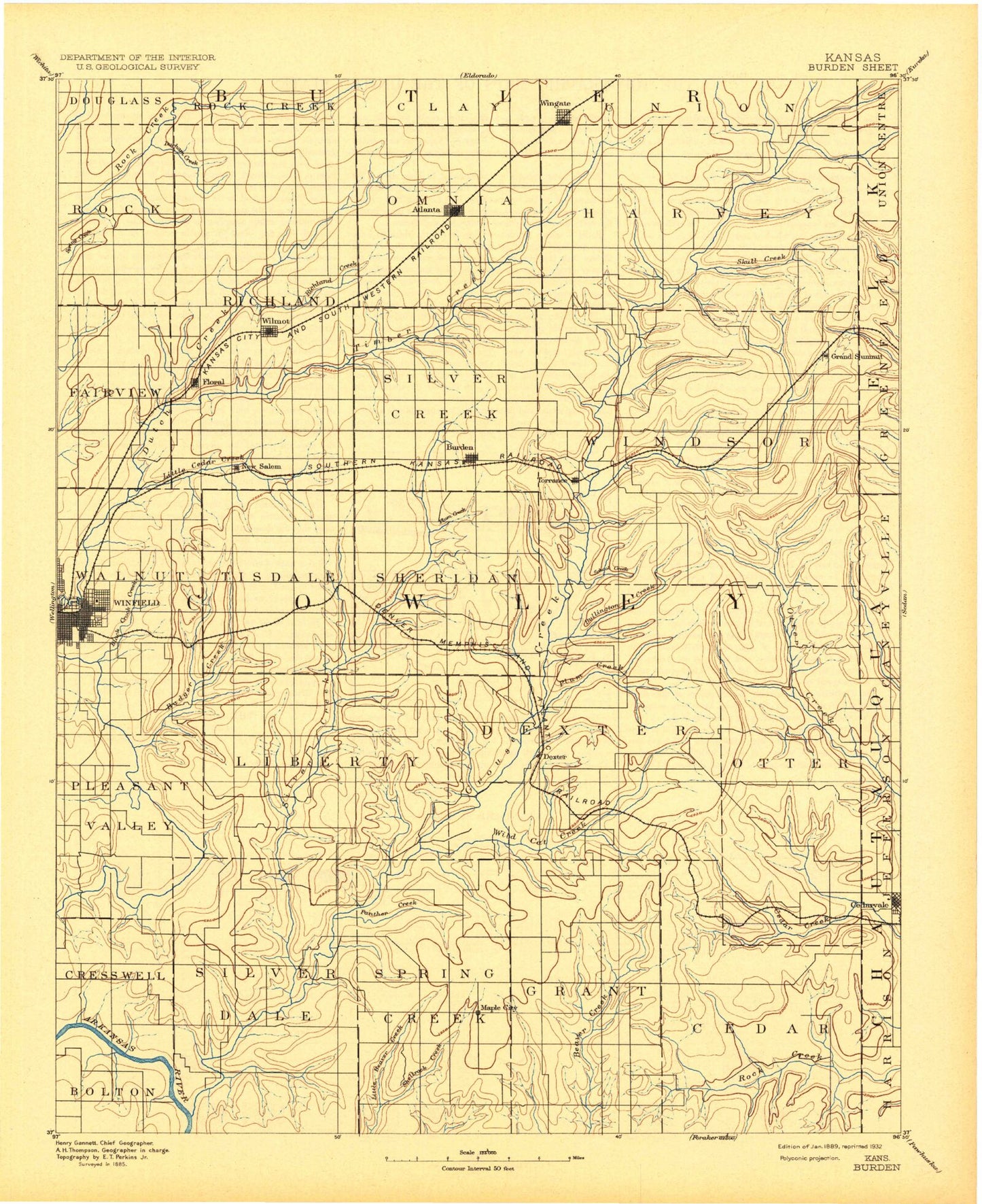
MyTopo
Historic 1889 Burden Kansas 30'x30' Topo Map
Couldn't load pickup availability
Historical USGS topographic map of Burdenin the states of Kansas, Oklahoma. Scale: 1:125000. Print size: 17" x 24"
This map was published in 1889 and is in the following counties: Butler, Chautauqua, Cowley, Elk.
The map contains contour lines, roads, rivers, towns, streams, and lakes. Printed on high-quality waterproof paper with UV fade-resistant inks.
Contains the following named places: Silverdale, Camp Ko-Ha-Me, Otter Creek, Township of Pleasant Valley, Donahue Creek, Township of Cedar, Township of Grant, Little Crabb Creek, Cowley County State Park, Panther Creek, Silver Creek, Shellrock Creek, Albright Oil Field, Rahn Oil Field, Wildcat Creek, Grouse Creek Club, Larcom Oil Field, Walnut Bend Oil and Gas Field, Township of Silverdale, Cedar Vale, Bear Creek, Spring Creek, Dog Run, Whartenby Creek, Acker Creek, Rush Creek, Branson Creek, North Cedar Creek, South Cedar Creek, Cup and Saucer Hills, Winfield South Oil Field, Big Badger Creek, Seacat Oil Field, Redd Valley, Baugh Canyon, Posey Oil Field, Posey Creek, Island Park, Winfield Oil Field, West Badger Creek, Black Crook Creek, Winfield, Township of Walnut, Albright Park, Township of Liberty, Township of Tisdale, Werner Oil Field, Maddox North Oil Field, Township of Dexter, Cabin Valley Oil Field, East Badger Creek, Deer Creek, Horse Creek, Snake Creek, Pebble Creek, Harper Creek, Turkey Creek, Township of Sheridan, Dexter, Plum Creek, Township of Spring Creek, Bullington Creek, Boone Ranch, Fulsom Ranch, Mills Ranch, Ramsey Ranch, Hogback Hill, Shafer Creek, Jim Creek, Crabb Creek, Blue Branch, Cambridge, Coon Creek, School Creek, Township of Windsor, Cedar Creek, Burden Oil Field, Shannon Oil Field, Bolack Oil Field, Turner North Oil Field, Burden, Plum Creek, Township of Silver Creek, Eastman Oil Field, Deichman Oil Field, Hittle Oil Field, New Salem, Wilmot Floral Oil Field, Biddle Oil Field, Frog Hollow Oil Field, Township of Salem, Dutch Creek, David Oil Field, Township of Fairview, Cedar Creek, Box Oil Field, Goose Creek, Lower Dutch Creek, Upper Dutch Creek, Hannah Oil Field, Wehrman Oil Field, Mahannah Oil Field, Franklin Creek, Wagoner Creek, Riley Creek, Ferguson Creek, Ferguson Ranch, Gardners Branch, Grand Summit Oil Field, Township of Harvey, Dory Oil Field, Mount Tabor Oil Field, Chigger Creek, Swisher Branch, Combs Oil Field, Durham Creek, Rock Oil Field, Township of Rock Creek, Stalter Branch, Clay Oil Field, Township of Richland, Combs Northeast Oil Field, Couch Oil Field, Atlanta, Richland Creek, Grouse Creek Oil Field, Township of Omnia, Grouse Creek, Cowley State Fishing Lake, Lake Wynds Dam, Lake Wynds, Cowley County State Lake Dam, Cowley County State Lake, Flint Hills, Glen Crouse, Timber Creek Lake, Otto, Winfield Plaza, Vinton, Cameron, Maple City, Taussig, Tisdale, Eaton, Hooser, Grand Summit, Floral, Wilmot, Wingate, Cowley County, Township of Otter, City of Winfield, Parkerfield, City of Burden, City of Cambridge, City of Cedar Vale, City of Atlanta, City of Dexter, City of Parkerfield, Prairie View Christian Camp, Burden Wastewater Plant, Winfield Wastewater Plant, Winfield Municipal Power Plant, Winfield Aquatic Center, Winfield Water Treatment Plant, Atlanta Wastewater Treatment Plant, Cambridge Wastewater Plant, Dexter Wastewater Treatment Facility, Glenview Estates Mobile Home Park, Louanns Mobile Home Park, Quail Ridge Golf Course, Fleming Feed and Grain Company Grain Elevator Number 2, Dog Run, Whartenby Creek, Acker Creek, Rush Creek, Branson Creek, Flint Hills