
MyTopo
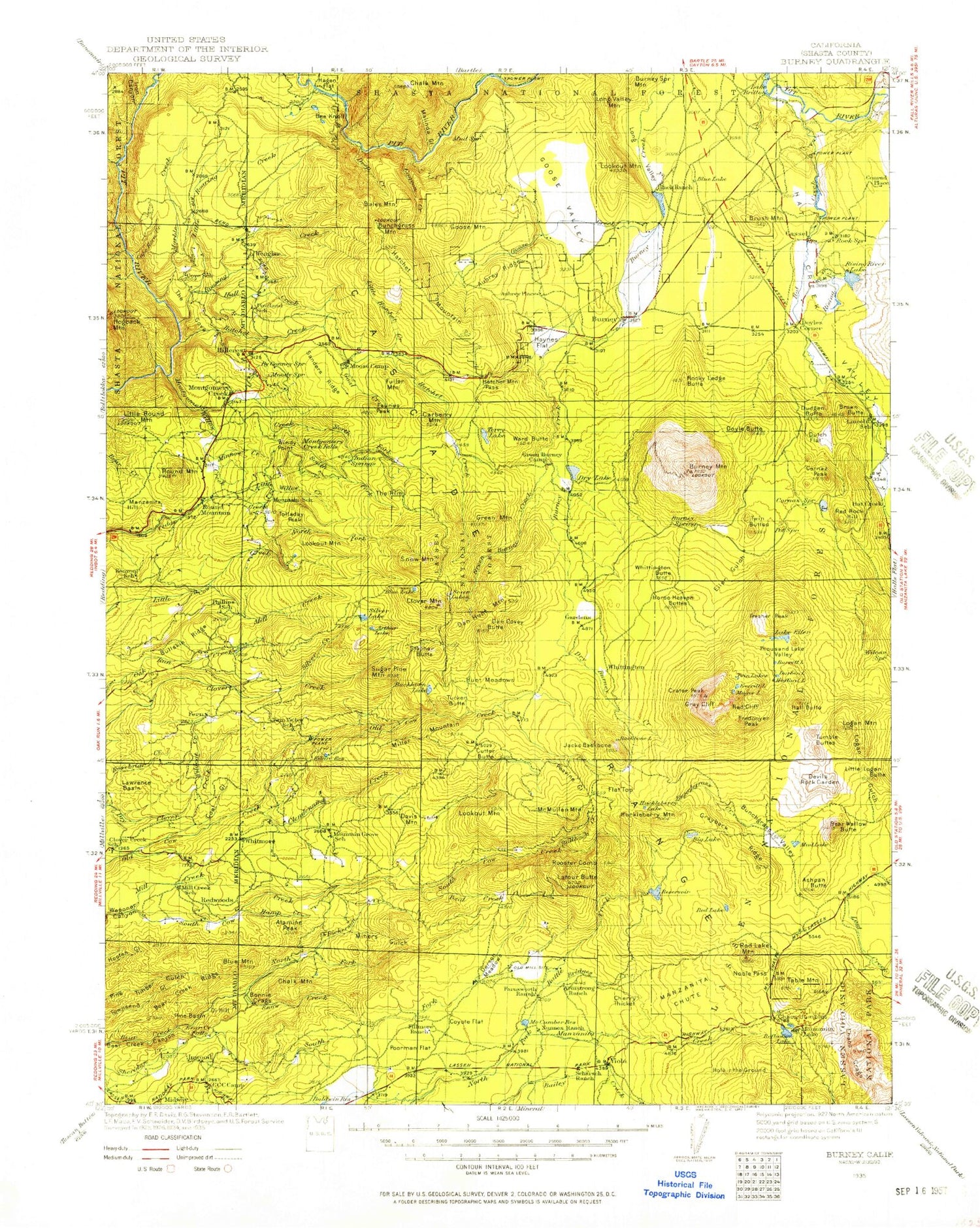
Historic 1935 Burney California 30'x30' Topo Map
Couldn't load pickup availability
Historical USGS topographic map of Burney in the state of California. Scale: 1:125000. Print size: 17" x 24"
This map was published in 1935 and is in the following counties: Shasta.
The map contains contour lines, roads, rivers, towns, streams, and lakes. Printed on high-quality waterproof paper with UV fade-resistant inks.
Contains the following named places: Alamine Peak, Armstrong Ranch, Bailey Creek Meadows, Barrett Lake, Bear Creek Falls, Bear Creek Ridge, Blue Mountain, Bonnie Craigs, Bridges Creek, Buckhorn Forest Fire Station, Bullskin Ridge, Bunchgrass Campground, Bunchgrass Creek, Bunchgrass Trail, Bunchgrass Valley, Camp McCumber, Chalk Mountain, Coal Gulch, Cottonwood Gulch, Coyote Flat, Crater Peak, Cypress Camp Trail, Cypress Campground, Dan Hunt Meadows, Deer Creek, Deer Flat, Dersch Meadows, Devils Rock Garden, Dickerson Creek, Durbin Lake, Lake Eiler, Everett Lake, Farnsworth Ranch, Fluhart Basin, Freaner Peak, Fredonyer Peak, Glendenning Creek, Gray Cliff, Hagaman Gulch, Hall Butte, Hamp Creek, Hootman Ranch, Hufford Lake, Latour Butte, Lawrence Basin, Little Logan Butte, Little Valley, Logan Gulch, Logan Mountain, Long Hollow, Lower Twin Lake, Magee Lake, Magee Peak, Magee Trail, McCumber Flat, McCumber Reservoir, Mill Creek, Miners Gulch, Mud Lake, North Battle Creek Reservoir, North Fork Bear Creek, Nunes Ranch, Pine Basin, Poorman Flat, Red Cliff, Reservoir Public Camp, Ritts Mill, Rooster Comb, Scharsch Ranch, Silver Creek, Slaughter Pole Creek, Bullhock Creek, Manzanita Creek, Snow Creek, South Cow Creek Campground, Tamarack Swale, Tamarack Swale Trail, Thatchers Meadows, Thousand Lakes Valley, Thousand Lakes Wilderness, Upper Twin Lake, Whitmore, Wilcox Trail, Wildcat Creek, Witherow Ranch, Iron Canyon Creek, Fluhart Gap, Inwood, Box Lake, Arkright Flat, Arthur Lake, Ashpan Butte, Ashpan Flat, Atkins Creek, Aubrey Ridge, Backbone Lake, Bales Mountain, Baum Lake, Beal Creek, Big Lake, Black Ranch, Blackberry Creek, Blue Lake, Braden Sand Pit, Brown Butte, Brush Mountain, Brush Patch, Buckhorn Lake, Buffum Creek, Bunchgrass Mountain, Burney Mountain, Bush Barl, Butcher Gulch, Butter Creek, Cantrell Creek, Canyon Creek, Cape Horn Creek, Carberry Flat, Cassel, Chalk Mountain, Chalk Reservoir, Chaos Crags Trail, Chaos Crater, Chaos Jumbles, Cinder Butte, Clover Mountain, Conrad Ranch, Cornaz Lake, Cove School, Old Cow Creek Meadows, Crags Lake, Crystal Lake, Dan Covey Butte, Deep Creek, Deep Creek Campground, Deep Hole, Devils Canyon, Doyle Butte, Doyles Corner, Dry Burney Creek, Dry Lake, Dudgen Butte, Dutch Flat, Dwarf Forest, Eiler Gulch, Flat Woods, Four Corners, Fox Creek, Fuller Flat, Fuller Mountain, Goat Creek, Goose Creek, Goose Mountain, Goose Valley, Goose Valley Ranch, Grayback Ridge, Green Burney Creek, Green Mountain, Hagen Flat, Hall Creek, Hat Creek, Hat Creek Forest Service Station, Hat Creek Valley, Hatchet Creek, Hatchet Mountain, Hatchet Mountain Pass, Hawk Creek, Haynes Flat, Hidden Valley Ranch, Hillcrest, Hillcrest Forest Fire Station, Hogback Creek, Hogback Mountain, Honn Creek, Honn Campground, Huckleberry Lake, Huckleberry Meadows, Huckleberry Mountain, Hunt Creek, Iron Canyon, Jackrabbit Flat, Jacks Backbone, Kilarc Reservoir, Latour Fire Station, Latour Demonstration State Forest, Latour Trail, Lee March Gulch, Lily Pond, Little Hatchet Creek, Little Roaring Creek, Little Round Mountain, Long Valley, Lookout Mountain, Lookout Mountain, Lost Creek Camp, Lost Creek Diversion Flume, Malinda Gulch, Manzanita Chute, Manzanita Lake, Marble Creek, McMullen Mountain, Mill Creek, Miller Valley, Minnow Creek, Montgomery Creek, Montgomery Creek, Montgomery Creek Rancheria, Moose Camp, Mountain School, Nobles Pass, North Fork Little Cow Creek, North Fork Montgomery Creek, Oak Flat, Old Cow Creek Campground, Old Emigrant Trail, Old Green Burney Camp, Opdyke Hill, Peavine Gulch, Pit Four Reservoir, Pit Four Dam, Pit Five Dam, Red Lake, Red Lake Mountain, Red Mountain, Red Rock Hill, Reflection Lake, Richardson Creek, Rising River, Rising River Lake, Rising River Ranch, Roaring Creek, Roaring Creek Rancheria, Rocky Ledge, Round Mountain, Ruling Creek, Sanders Ridge


