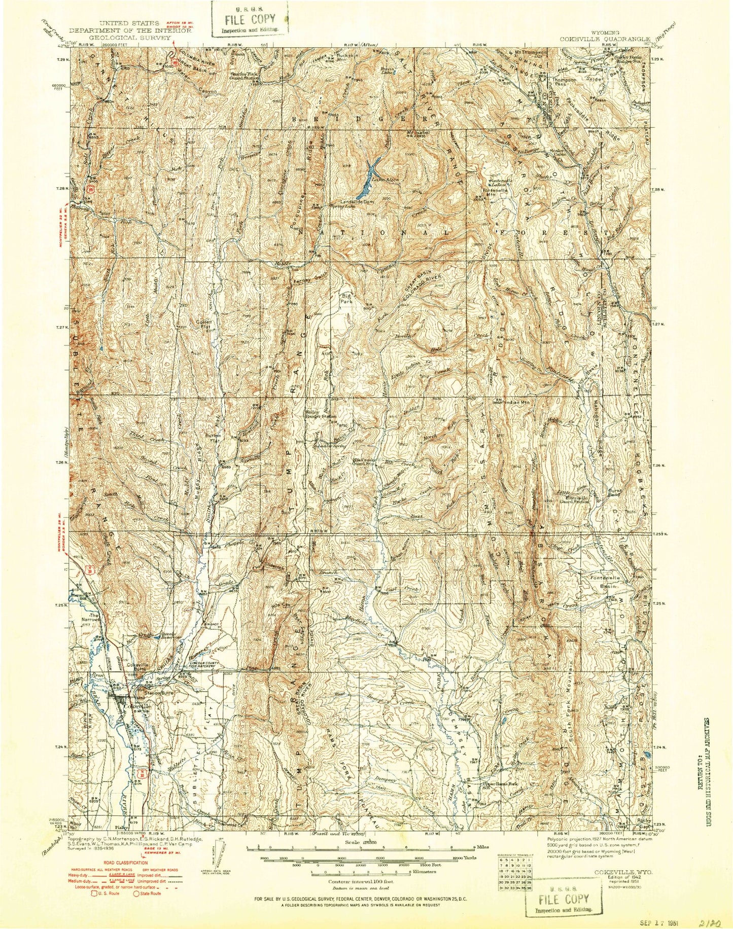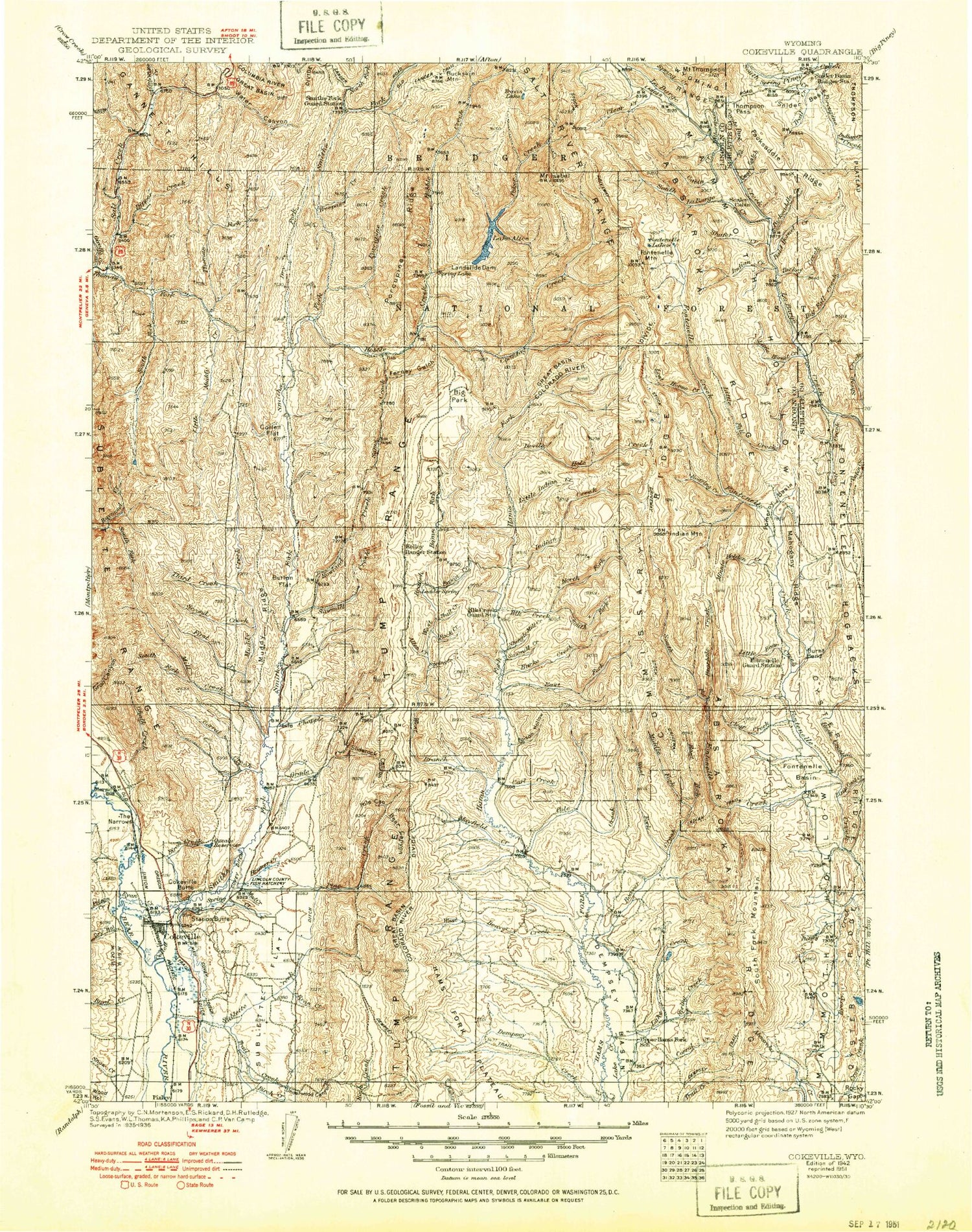
MyTopo
Historic 1942 Cakeville Wyoming 30'x30' Topo Map
Couldn't load pickup availability
Historical USGS topographic map of Cakeville in the state of Wyoming. Scale: 1:125000. Print size: 17" x 24"
This map was published in 1942 and is in the following counties: Lincoln, Sublette.
The map contains contour lines, roads, rivers, towns, streams, and lakes. Printed on high-quality waterproof paper with UV fade-resistant inks.
Contains the following named places: Boyd Hollow, Dry Hollow, Garrett Creek, Poison Creek, Potato Creek, Snow Hollow, Wood Hollow, Giraffe Creek, Aspen Creek, Bartlett Creek, Bear Gulch, Bear Trap Creek, Beaver Dam Creek, Big Hill, Birch Creek, Birch Gulch, Camp Creek, Camp Creek, Campfire Creek, Chalk Creek, Coal Branch, Coal Creek, Coke Mountain, Corral Creek, Corral Creek, D C P Ditch, Dempsey Basin, Devils Hole Creek, Devils Hole Lakes, Dixon Slough, East Stock Ditch, Emelle Ditch, Everly Creek, Fawn Creek, Fenn Creek, First Creek, Forgen Slough, Forked Creek, Fourth Creek, Fourth Creek Reservoir, Granny Peak, Huff Lake, Indian Creek, Johnson Spencer Ditch, Lake Creek, Larson Reservoir, Little Fall Creek, Little Indian Creek, Lost Creek, Lost Horse Creek, Lund Draw, Mau Ditch, Mill Creek, Mistum Creek, Moore Creek, Mud Creek, Mud Lakes, Muddy Creek, Muddy Ridge, Noblitt Ditch, North Fork Roney Creek, Oregon Trail Lander Cutoff, Pine Knoll, Pine Tree Creek, Pink Hill, Pomeroy Basin, Quealy Reservoir, Raymond Basin, Red Park, Roaring Creek, Rocky Gap, Rocky Point, Roney Creek, Rough Creek, Ryan Creek, Ryan Creek, Second Creek, Shearing Corral Hollow, Sheep Dip Creek, South Fork Hams Fork, South Fork Mill Creek, South Fork Mountain, South Fork Raymond Creek, South Fork Smiths Fork, South Fork Stoner Creek, South Fork Sublette Creek, Spring Creek, Spring Creek, Spring Gulch, Stepp Creek, Stoffer Ridge, Stoner Nelson Wheelock Ditch, Sublette Creek, Sublette Flat, Tanner Hunt Garrett, Taylor Creek, The Narrows, Third Creek, Trail Creek, Underwood Canyon, Way Creek, West Beaver Creek, West Fork Dempsey Creek, White Water Ditch, Wilkinson Creek, Windmill Draw, Wright Divide, Wyman Creek, Hams Fork Creek, North Fork Dempsey Creek, Coal Creek, Spring Branch, Marse, Pixley, Coantag Creek, La Barge Creek, South La Barge Creek, Alice Creek, Lake Alice, Allred Flat, Bald Hornet Creek, Basin Creek, Bear Canyon, Bearhole Creek, Beaver Creek, Big Fall Creek, Big Park, Bird Creek, Bloom Hollow, Bluejay Creek, Boney Canyon, Booth Creek, Bourne Creek, Bruner Creek, Buck Canyon, Buckskin Knoll, Bull Creek, Bull Mountain, Burke Creek, Burnt Bend, Button Flat, Cabin Creek, Carl Creek, Chappel Creek, Claudia Creek, Clear Creek, Clear Creek, Cliff Creek, Coal Creek, Collett Flat, Commissary Ridge, Coyote Park, Coyote Park Creek, Crystal Lake, Deadline Ridge, Deer Gulch, Dock Creek, Dry Fork Smiths Fork, East Fork Beaver Creek, East Fork Hams Fork, East Fork Pole Creek, East Fork Salt Creek, Elbow Creek, Electric Creek, Electric Peak, Elk Creek, Emigrant Trail, Ferney Gulch, Florey Creek, Fontenelle Basin, Fontenelle Hogbacks, Fontenelle Lakes, Grade Canyon, Grade Canyon Creek, Graham Peak, Green Knoll, Grindstone Creek, Hams Fork Ridge, Hawkins Creek, Hobble Creek, Hock Creek, Horse Creek, Huff Creek, Indian Creek, Indian Creek, Indian Ridge, Isabel Creek, Mount Isabel, Japanese Park, Kelley Creek, Kelley Guard Station, Lake Mountain, Lake Mountain Creek, Lander Creek, Landslide Dam, Little Bear Creek, Little Clear Creek, Little Coal Creek, Little Hornet Creek, Little Indian Creek, Little Jo Creek, Little Muddy Creek, Little Park, Little Park Creek, Little White Creek, Lost Creek, Mack Creek, Mahogany Creek, Mahogany Ridge, Mammoth Hollow, Mayfield Creek, McKay Creek, Middle Fork Beaver Creek, Minnehaha Creek, Minnie Holden Creek, Mule Meadow, Murdock Creek, Nameless Creek, North Bartlett Creek, North Chappel Creek, North Fork Elk Creek, North Fork Lander Creek, North Fork Smiths Fork, North Fork Stoner Creek, Nugent Park, Oyster Ridge, Packsaddle Creek, Packsaddle Ridge, Packstring Creek, Perkins Creek, Perry and Partridge Ditch, Pine Creek, Pine Knoll, Poison Hollow, Poker Creek, Pole Canyon