MyTopo
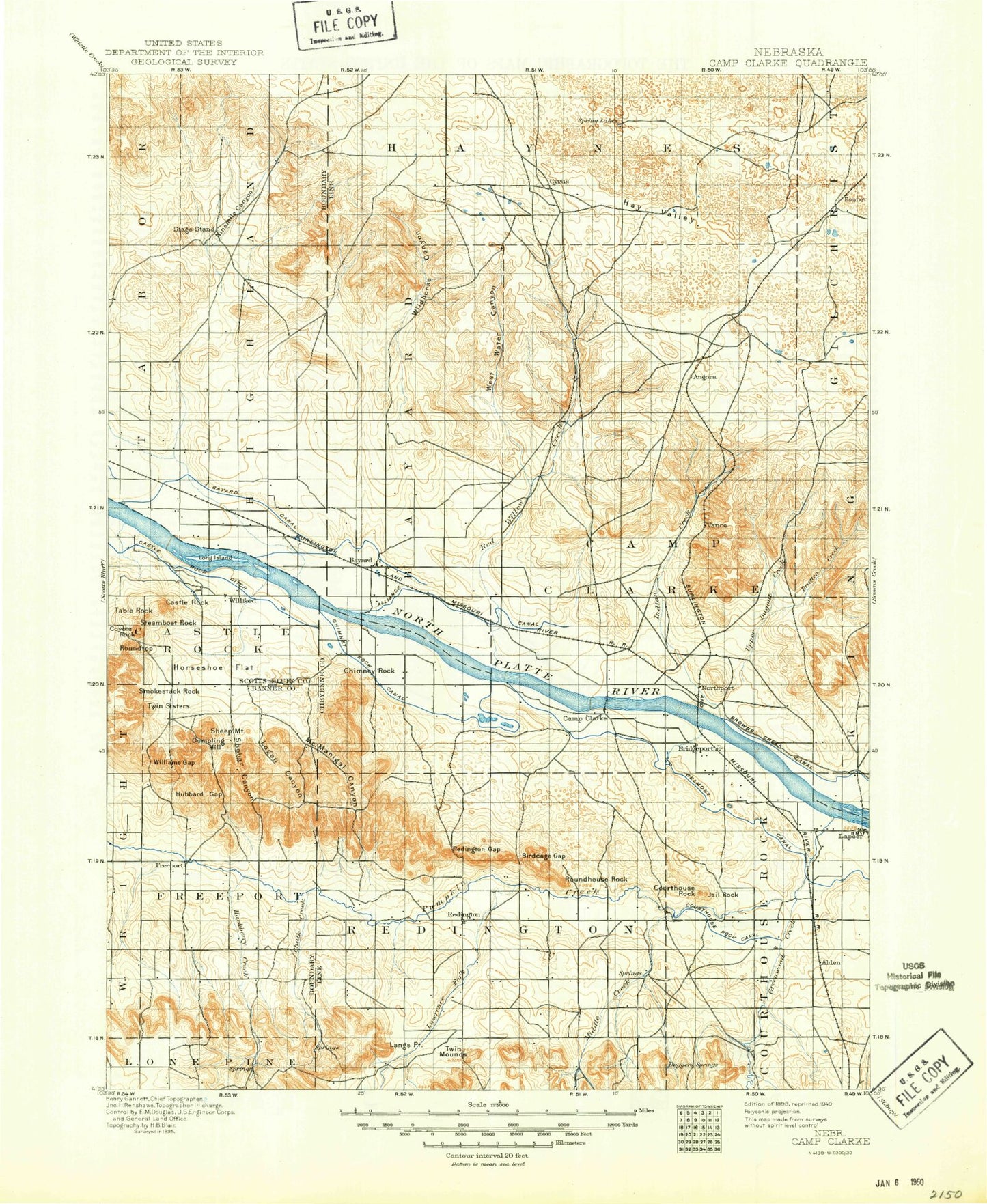
Historic 1898 Camp Clarke Nebraska 30'x30' Topo Map
Couldn't load pickup availability
Historical USGS topographic map of Camp Clarke in the state of Nebraska. Scale: 1:125000. Print size: 17" x 24"
This map was published in 1898 and is in the following counties: Banner, Morrill, Scotts Bluff.
The map contains contour lines, roads, rivers, towns, streams, and lakes. Printed on high-quality waterproof paper with UV fade-resistant inks.
Contains the following named places: Alliance Canal, Alliance Drain, Angora, Bastron Lake, Bayard, Bayard Drain, Bayard Drain, Bedding Canyon, Belmont Canal, Belmont Dam, Bighorn Gulch, Bishop Canyon, Bratten Creek, Bricker Lakes, Bridgeport, Bridgeport State Recreational Area, Browns Creek Channel, Camp Clarke Drain, Castle Rock, Castle Rock Canal, Chimney Rock National Historic Site, Chimney Rock Canal, Courthouse Rock Canal, Coyote Canyon, Coyote Rock, DeGraw Drain, Dumpling Hill, Dunlap Oil Field, East Ninemile Canyon, East Ninemile Creek, Empire Canal, Gebauer Lake, Greenwood Creek, Greenwood Oil Field, Hackberry Creek, Hart Oil Field, Hay Valley, High Line Canal, Highline Canal, Hope Creek, Horseshoe Bend, Hubbard Gap, Indian Creek, Jail Rock, Last Chance Canal, Lawrence Fork, Logan Canyon, Long Island, Langs Point, Lowline Canal, McGrew, McManigal Canyon, Meredith Ammer Canal, Meredith Canal, Middle Creek, Minatare Canal, Minatare Drain, Lake Minatare, Moffat Drain, Moomaw Corner, Ninemile Canal, Ninemile Channel, Ninemile Creek, Northport, Northport Canal, Pumpkin Creek, Rangler Canal, Red Willow Creek, Redington, Roundhouse Rock, Roundtop, Sheep Mountain, Shobar Canyon, Short Line Canal, Smokestack Rock, Steamboat Rock, Stuckenhole Drain, Table Rock, Towers, Twin Sisters, Upper Dugout Creek, West Water Creek, Wildhorse Canyon, Wildhorse Dam, Wildhorse Drain, Williams Gap, Chimney Rock, Redington Gap, Alden, Atkins, Baxter, Bonner, Bradley, Craft, DeGraw, Kemp, Mohler, Perrin, Piper, South Bayard, Tony, Vance, Morrill County, Courthouse Rock, Ross Canyon Dam, Ross Canyon Reservoir, Roberts Dam, Roberts Reservoir, Muhr Dam, Muhr Reservoir, Horn Dam 6, Horn Reservoir 6, Horn Dam 4, Horn Reservoir 4, Huffman-Grimm Dam, Huffmann-Grimm Reservoir, Wildhorse Dam 9-A, Wildhorse Reservoir 9-A, King Ranch Dam, King Ranch Reservoir, Linch Dam, Linch Reservoir, Wildhorse Dam 5-A, Wildhorse Reservoir 5-A, Wildhorse Dam 14-A, Wildhorse Reservoir 14-A, Loomis Dam, Loomis Reservoir, Hall Dam, Hall Reservoir, Blackburn Dam, Blackburn Reservoir, Birchfield Dam, Birchfield Reservoir, Horn Dam, Horn Reservoir, Jessup Dam, Jessup Reservoir, Davidson Dam, Davidson Reservoir, Linch Dam, Funk Dam, Funk Reservoir, Belmont Diversion Dam, Belmont Diversion Reservoir, Harless-Ogard Dam, Harless-Ogard Reservoir, West Water Creek Dam, West Water Creek Reservoir, Harrys RV Park, Sunrise East Campground, Butte View Campground, North Cove Campground, Nine Mile Creek State Wildlife Management Area, Trinidad Bean and Elevator Company Elevator, Kelley Bean Company Incorporated Elevator, Bayard, Bridgeport, Trinidad Bean and Elevator Company Elevator, Morrill County Sheriffs Office, Morrill County Fairgrounds, Lakeview Mobile Park, East Bayard, Scoular Company Elevator, Golden Acres Motel and RV Park, Bridgeport Camping Area, Oregon Trail Wagon Train Campground, Chimney Rock Golf Course, Courthouse and Jail Rock Golf Course, Camp Clarke Bridge and Sidney - Black Hills Trail Historical Marker, Round Rock, Twin Mounds, Chalk Mound, East Bayard Election Precinct, East Camp Clarke Election Precinct, Haynes Election Precinct, Highland Election Precinct, North Camp Clarke Election Precinct, Redington Election Precinct, West Bayard Election Precinct, West Camp Clarke Election Precinct, City of Bridgeport, City of Bayard, Village of McGrew, Darnall Feedlot, Lapaseotes Feedyard