
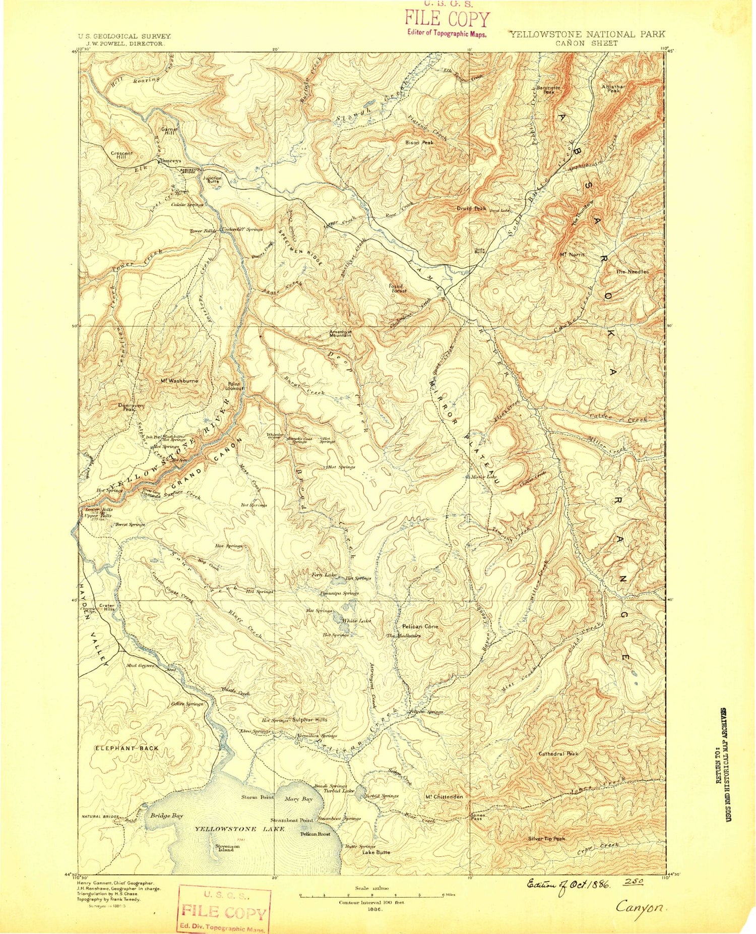
MyTopo
Historic 1886 Canyon Wyoming 30'x30' Topo Map
Couldn't load pickup availability
Historical USGS topographic map of Canyonin the states of Wyoming, Montana. Scale: 1:125000. Print size: 17" x 24"
This map was published in 1886 and is in the following counties: Park, Teton.
The map contains contour lines, roads, rivers, towns, streams, and lakes. Printed on high-quality waterproof paper with UV fade-resistant inks.
Contains the following named places: Buffalo Creek, Buffalo Plateau Trail, Hellroaring Creek, Little Cottonwood Creek, Pebble Creek, Slough Creek, Soda Butte Creek, Abiathar Peak, Agate Creek, Alum Creek, Amethyst Creek, Amethyst Mountain, Amphitheater Creek, Antelope Creek, Artist Point, Barronette Peak, Bison Peak, Bliss Pass, Bluff Creek, Bog Creek, Bridge Bay, Bridge Creek, Broad Creek, Buck Lake, Buffalo Creek, Buffalo Plateau, Buffalo Plateau Trail, Bump-Sullivan Reservoir, Bumpus Butte, Burnt Creek, Cache Creek Patrol Cabin, Calfee Creek Patrol Cabin, Carnelian Creek, Cascade Creek, Cathedral Peak, Chalcedony Creek, Clear Lake, Cody Peak, Cottongrass Creek, Coyote Creek Trail, Crater Hills, Crystal Creek, Death Gulch, Deep Creek, Dewdrop Lake, Dunraven Pass, Dunraven Peak, Elephant Back Loop Trail, Elephant Back Mountain, Elk Antler Creek, Elk Creek, Elk Tongue Creek, Fern Lake, Fern Lake Patrol Cabin, Flint Creek, Floating Island Lake, Frost Lake, Garnet Hill, Geode Creek, Giant Castle Mountain, Glacial Boulder, Glacial Boulder Trail, Gull Point, Hayden Valley, Hellroaring Ranger Station, Holmes Point, Mount Hornaday, Ice Box Canyon, Jasper Creek, Junction Butte, Lake Butte, Lake Lodge, Lake Ranger Station, Lamar Canyon, Lamar Ranger Station, LeHardys Rapids, Little Buffalo Creek, Lost Creek Falls, Mary Bay, McBride Lake, Miller Creek Trail, Mirror Lake, Moss Creek, Mount Washburn Spur Trail, Yellowstone Natural Bridge, Mount Norris, Opal Creek, Pebble Creek Campground, Pelican Cone, Pelican Roost, Hornaday Creek, Pleasant Valley, Point Sublime, Pyramid Peak, Quartz Creek, Rainy Lake, Ribbon Lake Trail, Roosevelt Lodge, Rose Creek, Rose Creek, Round Prairie, Sevenmile Hole, Sevenmile Hole Trail, Shallow Creek, Shrimp Lake, Silvertip Peak, Slough Creek Patrol Cabins, Sour Creek, Sour Creek Trail, South Cache Creek, Specimen Ridge, Specimen Ridge Trail, Stonetop Mountain, Sulphur Creek, Sulphur Hills, Surface Creek, Tern Lake, The Cut, The Narrows, The Thunderer, Tower Creek, Tower Fall, Tower Fall Campground, Tower Ranger Station, Trout Creek, Turbid Lake, Upper Falls of the Yellowstone River, Wapiti Lake, Wapiti Lake Trail, Weasel Creek, White Lake, Wrangler Lake, Wrong Creek, Yancy Creek, Yellowstone River Trail, Thunderer Cutoff Trail, Thistle Creek, Eye of the Needle, Unnamed Creek, Frederick Peak, Grand View, Mirror Fork, Mirror Plateau, Bannock Ford, Buffalo Ford, Canyon Junction, Canyon Village, Devils Den, Fossil Forest, Lake Junction, Tower Junction, Yanceys, Bear Creek, Buffalo Fork, Cache Creek, Mount Chittenden, Clover Creek, Cold Creek, Cold Creek Patrol Cabin, Crow Creek Pass, Frost Lake Trail, Hague Mountain, Jones Pass Trail, Lamar River, Lamar River Trail, Little Lamar River, Little Saddle Mountain, Lovely Pass, Miller Creek, Mist Creek, Mist Creek Pass, Mist Creek Trail, Pelican Cone Trail, Pelican Creek, Pelican Creek Trail, Pelican Springs Cabin, Raven Creek, Sedge Creek, Stonecup Lake, Tern Lake Trail, Timothy Creek, Willow Creek, Ribbon Lake, Indian Pond, Lower Falls of the Yellowstone River, Lake, Astringent Creek, Calfee Creek, Crescent Hill, Druid Peak, Hedges Peak, Inspiration Point, Jones Pass, Lost Creek, Lost Lake, Pebble Creek, Pelican Valley, Silver Cord Cascade, Steamboat Point, Stevenson Island, Storm Point, Sulphur Mountain, The Needle, Trout Lake, Mount Washburn, Grand Canyon of the Yellowstone, Soda Butte Canyon, The Needle, Red Rock, Lookout Point, Cummings Creek, Overhanging Cliff, Yellowstone National Park Division, Lamar Valley, Soda Butte Crater, Soda Butte, Buffalo Creek, Buffalo Plateau Trail, Coyote Creek, Hellroaring Creek, Little Cottonwood Creek, Pebble Creek, Slough Creek, Soda Butte Creek, Buffalo Creek, Buffalo Plateau, Buffalo Plateau Trail, Coyote Creek Trail, Yellowstone River Trail, Pebble Creek, Soda Butte Canyon


