MyTopo
Historic 1943 Cape Ann Massachusetts 30'x30' Topo Map
Couldn't load pickup availability
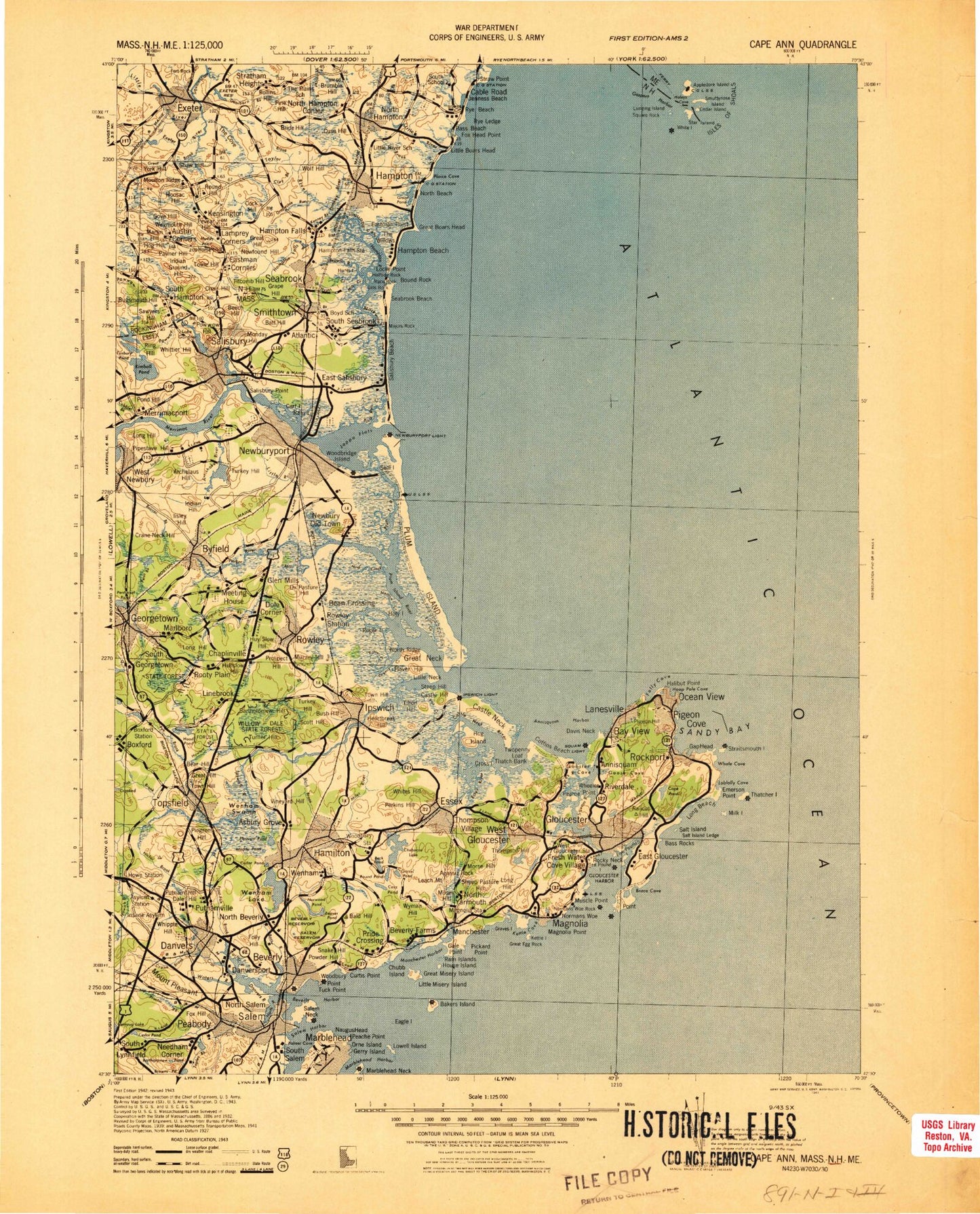
Historical USGS topographic map of Cape Ann in the state of Massachusetts. Scale: 1:125000. Print size: 17" x 24"
This map was published in 1943 and is in the following counties: Essex, Rockingham, York.
The map contains contour lines, roads, rivers, towns, streams, and lakes. Printed on high-quality waterproof paper with UV fade-resistant inks.
Contains the following named places: Nells Pond, Pleasant Pond, Lighthouse Point, Bobby Harris Pond, Old Churm, Marblehead Lighthouse, Chandler-Hovey Park, Crocker Park, Fountain Park, Patton Park, Hamilton, Annisquam River, Beverly Channel, Bow Bell Ledge, Chubb Islet, Dog Bar, Pancake Ground, Rams Horn Channel, Salem Channel, Salem Sound, Salem Willows Park, Straitsmouth Light, Cape Ann Light, Eastern Point Light, Bakers Island Light, Marblehead Light, North Pier Light, Ipswich Light, Annisquam Harbor Light, Rockport Breakwater Light, Gloucester Breakwater Light, Tenpound Island Light, Hospital Point Range Light, Derby Wharf Light, Cashman Park, Candlewood Golf Club, Cape Ann Golf Club, YMCA Camp, Iron Rail Girls Camp, Lynch Park, YMCA Camp, Salisbury Beach State Reservation, Plum Island State Park, Camp Sea Haven, Pingree Park, Liberty Tree Mall, North Shore Shopping Center, Obear Park, Forest River Park, Highland Park, Salem Common, Kernwood Park, Salem Country Club, Puritan Lawn Memorial Park, Old Newbury Golf Club, Amesbury Country Club, Atkinson Common, New Meadows Golf Club, Willowdale State Forest, Georgetown Rowley State Forest, Mount Ann Park, Salem Channel, West Gloucester Station, Gloucester Station, Rockport Station, Proctors Station, Salem Station, Newhall Station, Jones River Marshes, Farm Creek Marshes, Walker Creek Marshes, Little River Marshes, Dolliver Beach Neck Marshes, Chubb Creek Marshes, Good Harbor Beach Marshes, Mill Pond Marshes, Annisquam River Marshes, Essex Bay Marshes, Nelson Island Marshes, West Creek Marshes, Sand Creek Marshes, Eagle Hill River Marshes, Castle Neck River Marshes, Fox Creek Marshes, Ipswich River Marshes, Roger Island River Marshes, Blackwater River Marshes, Town Creek Marshes, Plum Island River Marshes, Little River Marshes, Parker River Marshes, Port Plaza, Cross Roads Shopping Plaza, Pickering Wharf, Mini Mall, Highland Plaza, Hawthorne Square Mall, Primrose Shopping Center, Kings Plaza, Endicott Plaza, Endicott Square, Danvers Plaza, Beverly Plaza, Elliot Street Shopping Plaza, Cabot Street Shopping Center / Professional Building, Ipswich Shopping Center, Burke Playground, YMCA Camp, Bass Rocks Country Club, Ravenswood Park, Tenpound Island Lighthouse, State Fort Park, Eastern Point Lighthouse, Annisquam Lighthouse, Cape Ann Lighthouse, Rockport Golf Club, Spring Pond Dam, Browns Pond Dam, Spring Pond, Sydneys Pond, Sydneys Pond Dam, Shoe Pond Dam, Mill Pond Dam, Salem Reservoir Dam, Folly Hill Reservoir, West Pond Outlet Dam, Norwood Pond Dam, Longham Reservoir Outlet Dam, Buswell Pond Dam, Putnamville Reservoir East Dike, Round Pond Dam, Putnamville Reservoir West Dike, Dykes Dam, Putnamville Reservoir Dam, Lily Pond Outlet Dam, Fernwood Lake West Dam, Wallace Pond Outlet Dam, Upper Banjo Pond Dam, Fernwood Lake East Dam, Fernwood Lake Dam, Haskell Pond Dam, Babson Reservoir Dam, Strangman Pond Dam, Mill River Culvert and Tide Gate Dam, Goose Cove South Dam, Mile Brook Reservoir, Mile Brook Dam, Goose Cove Southwest Dike, Goose Cove Northwest Dike, Goose Cove North Dam, Fish Brook Reservoir, Fish Brook Dam, Howes Pond Dam, Ipswich River Reservoir, Ipswich River Dam, Quarry Reservoir Dam, Hood Pond Dam, Lowe Pond Outlet Dam, Ipswich River Reservoir, Ipswich Mills Dam, Rantoul Pond Dam, Fourmile Pond Dam, Bull Brook Reservoir Dam, Dow Brook Reservoir Dam, Baldpate Pond Dam, Upper Millpond Dam, Lower Millpond Dam, Pentucket Pond Outlet Dam, Pentucket Pond Outlet Reservoir, Parker River Dam at Central Street, Parker River Reservoir, Parker River Dam, Parker River Reservoir, Parker River Dam, Parker River Reservoir, Artichoke River Dam, Mill Pond Dam, Lower Artichoke Reservoir Dam, Bailey Pond Dam, Lake Attitash Dam, Lake Gardner Dam, Tuxbury Pond Outlet Dam, Crowninshield-Bentley House, T-Wharf, Rocky Neck Art Colony, Fishermens Monument, Masconomo Park, Lindall Hill, Dales Hill, Ferncroft Hill, Sandy Beach, Long Point, LIttle Old Town Hill, Emersons Rocks, Little Good Harbor, Annisquam River, Ornes Hill, Powder House Hill, Little Turners Hill, Dog Bar Channel, Newburyport Harbor Light, Cushing, Ipswich Bay Yacht Club, Middle Ground, North Channel, Burnham Rocks, Saturday Night Ledge, Kettle Island Ledge, Essex County, South Channel, Blueberry Hill, B W Palmer State Park, Halibut Point Reservation, Misery Island Reservation, Front Beach, Bearskin Neck, Topsfield Station, Oakes Cove, Parker River National Wildlife Refuge, Bear Hill, Crooked Pond, Fourmile Pond, Bow Ridge, Crystal Pond, Beech Hill, Grape Hill, Lucy Brook, Cedar Pond, Prospect Hill, Allen Creek, Allen Rock, Badgers Rock, Black Rock Creek, Black Rocks, Browns Island, Browns Point