MyTopo
Historic 1942 Cape Cod Bay Massachusetts 30'x30' Topo Map
Couldn't load pickup availability
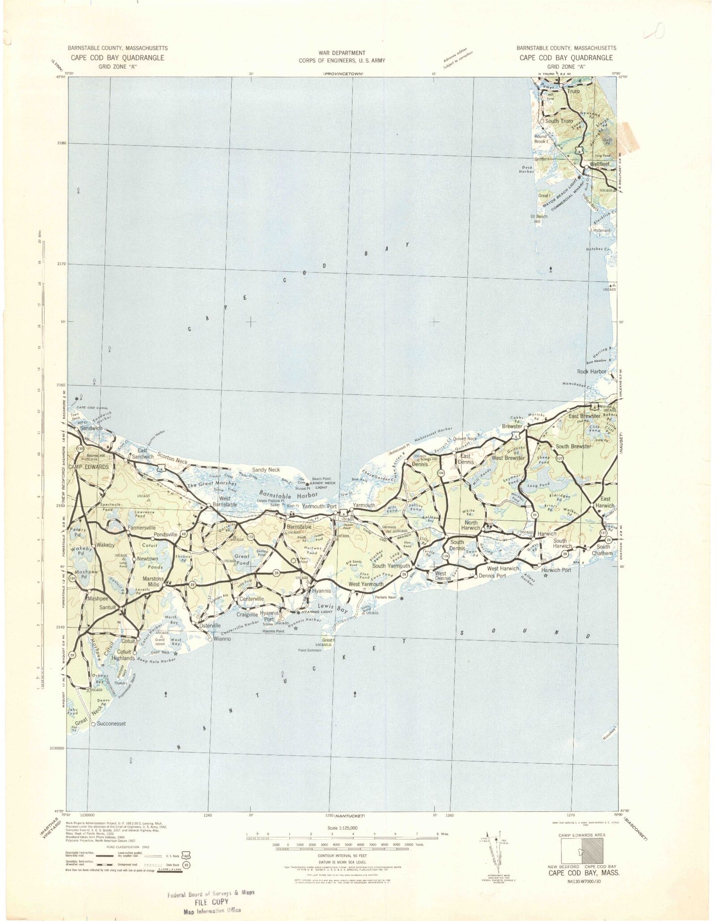
Historical USGS topographic map of Cape Cod Bay in the state of Massachusetts. Scale: 1:125000. Print size: 18" x 24"
This map was published in 1942 and is in the following counties: Barnstable, Plymouth.
The map contains contour lines, roads, rivers, towns, streams, and lakes. Printed on high-quality waterproof paper with UV fade-resistant inks.
Contains the following named places: Featherbed Swamp, Jeremy Point, Wellfleet Town Pier, Bishop and Clerks, Broken Ground, Gazelle Rock, Southwest Rock, Wreck Shoal, Cape Cod Canal Breakwater Light, Beach Point Light, Maraspin Creek Entrance Light, Sesuit Harbor West Jetty Light, Rock Harbor Range Light, Wellfleet Harbor Breakwater Light, Andrews River East Jetty Light, Wychmere Harbor Jetty Light, Allens Harbor Breakwater Light, Bass River West Jetty Light, Hyannis Breakwater Light, West Bay Entrance Light, Girl Scout Camp, Lowell Park, 4-H Club Camp, Yarmouth Campgrounds, Veterans Memorial Park, Kalmus Park Beach, Camp Hayward, Camp Lyndon, Camp Burgess, New Seabury Golf Club, Brewster County Club, Bass River Golf Club, Dennis Pines Golf Club, Sandwich Harbor Marshes, Scorton Creek Marshes, Squaw Island Marshes, Craigville Marshes, Mill Pond Marshes, Parkers River Marshes, Bass Hole Marshes, Swan Pond River Marshes, Quivett Creek Marshes, Sesuit Creek Marshes, Namskaket Creek Marshes, Little Namskaket River Marshes, Sunken Meadows Marshes, Silver Spring Brook Marshes, Indian Neck Marshes, Loagy Bay Marshes, Pamet River Marshes, Herring River Marshes, Bucks Creek Marshes, Great River Marshes, Flat Pond Marshes, Airport Shopping Center, Capetown Shopping Center, Capetown Plaza, Centerville Shopping Center, All Cape Shopping Center Picture Pond Plaza, Cape Cod Mall, Christmas Tree Plaza, South Yarmouth Plaza, Holly Plaza, Youth Forestry Camp, Hawksnest State Park, Boy Scout Camp, Massachusetts State Game Farm, Massachusetts State Fish Hatchery, Massachusetts State Fish Hatchery, Bodfish Park, Lowell Holly Reservation, Barnstable County Fairgrounds, Town of Barnstable Public Lands, Massachusetts State Game Farm, Shiverick Shipyard, Old Higgins Windmill, Sealand of Cape Cod, Stony Brook Mill, Baxters Mill, Poppenesset Bird Sanctuary, Sampsons Island Sanctuary, Benjamin Marstons Mill Site, Sandy Neck Beach, Mashpee River Dam, Baxter Grist Mill Dam, Lower Mill Pond Dam, Kennedy Compound, Old Briar Patch Trails, Mayos Beach Light, Winslows Narrows, Clarks Point, Cobbs Point, Bells Neck, Silver Spring Harbor, Kolb Rock, Sand Pond, Grass Pond Bog, Grassy Nook, Tawasentha Hill, Hatches Creek, Audubon Bird Sanctuary, Cape Cod Rail Trail, Great Island Trail, Duck Harbor Beach, Hallets Rock, Senator Shoal, Barnstable Municipal Airport Aero Light, Nickerson State Forest Park, North Pond, Anns Cove, Abigails Brook, Simons Narrows, Washburn pond, Combs Pond, Naomi Pond, Springhill Beach, Shoestring Bay, West Pond, Mill Pond, Sunken Meadow Beach, Hatch Beach, Cape Cod National Seashore, Cape Cod, Barnstable County, John F Kennedy Memorial, Herring River Marshes, Eastham Dunes, Sandy Neck Dunes, Kelleys Bay, Amos Pond, Baxter Neck, Bluff Point, Bog Pond, Cotuit, Cotuit Anchorage, Cotuit Bay, Cotuit Highlands, Crocker Neck, Dam Pond, Daniels Island, Dead Neck, Dean Pond, Eagle Pond, Flat Pond, Fullers Marsh, Gooseberry Island, Great Neck, Handy Point, Holly Marsh, Point Isabella, Jehu Pond, Jim Pond, Joshua Pond, Lewis Pond, Lily Pond, Little Island, Little River, Little Thatch Island, Lone Rock, Lovells Pond, Lumbert Pond, Marstons Mills, Mashpee, Mashpee Neck, Mashpee River, Maushop Village, Meadow Point, Micah Pond, Neck Pond, Noisy Point, North Bay, Ockway Bay, Osterville, Osterville Grand Island, Oyster Harbors, Oyster Harbors Beach, Parker Pond, Pattys Pond, Pine Island, Pine Tree Corner, Pocknett Neck, Popponesset Bay, Popponesset Beach, Popponesset Beach, Popponesset Creek, Popponesset Island, Punkhorn Point, Quaker Run, Rock Landing, Rushy Marsh Pond, Ryefield Point, Saint Marys Island, Sam Pond, Sampsons Island, Santuit, Santuit Pond, Santuit River, Seapuit River, South Mashpee, Succonnesset Point, Succonnesset Shoal, Thatch Island, Tims Point, West Bay, Wills Hill, Witch Pond, Wianno, Aunt Bettys Pond, Barnstable, Bass Creek, Bass Creek, Beach Point, Bearse Pond, Blish Point, Boat Cove Creek, Brickyard Creek, Bridge Creek, Broad Sound, Calves Pasture Point, Centerville, Centerville Harbor, Centerville River, Channel Rock, Barnstable Harbor, Clay Hill, Cobbs Hill, Cobbs Village, Hayes Point, Coleman Pond, Colonial Acres, Craigville, Craigville Beach, Craigville Beach, Crystal Lake, Cummaquid, Dennis Pond