
MyTopo
Historic 1891 Carnesville Georgia 30'x30' Topo Map
Couldn't load pickup availability
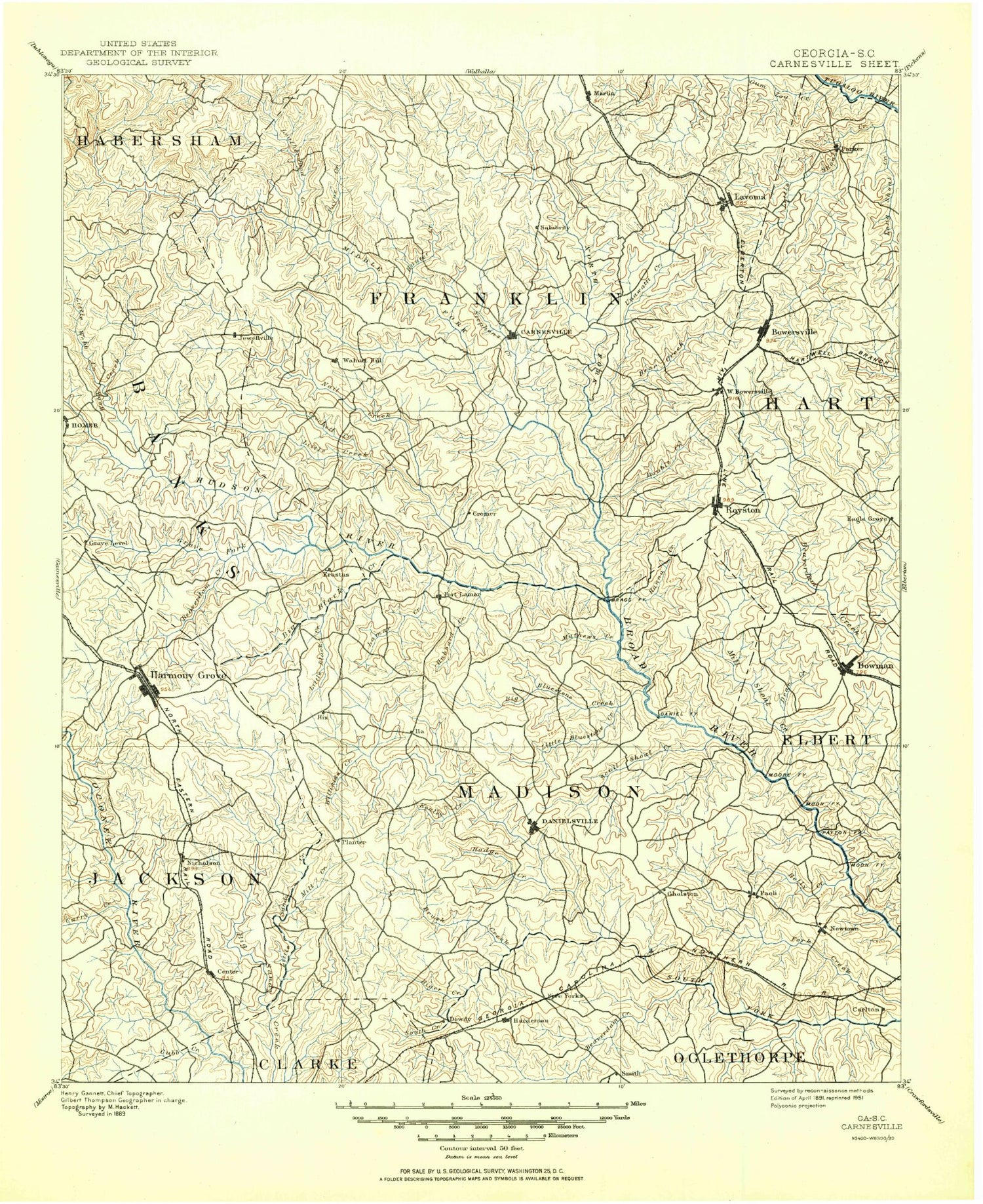
Historical USGS topographic map of Carnesville in the state of Georgia. Scale: 1:125000. Print size: 18" x 24"
This map was published in 1891 and is in the following counties: Banks, Clarke, Elbert, Franklin, Habersham, Hart, Jackson, Madison, Oconee, Oglethorpe, Stephens.
The map contains contour lines, roads, rivers, towns, streams, and lakes. Printed on high-quality waterproof paper with UV fade-resistant inks.
Contains the following named places: Adams Lake, Bear Creek, Beaver Creek, Beaverdam Creek, Black Creek, Bluestone Creek, Borders Creek, Brays Lake, Brooks Lake, Brooks Lake, Brush Creek, Butler Creek, C C Hall Monument, Camp Maranatha, Caney Branch, Carnesville, Clarks Creek, Clouds Creek, Comer, Crawford Creek, Crockett Creek, Crooked Creek, Cubb Creek, Deans Lake, Deep Creek, Double Branch, East Sandy Creek, Fork Creek, Furnace Creek, Hardeman Creek, Hickory Level Creek, Hills Lake, Hog Branch, Holly Creek, Hubbard Creek, Hull, Ila, Lake Jarekit, Kelly Creek, Lake Yamacutah, Lamar Creek, Lavonia, Little Bear Creek, Little Black Creek, Little Crawford Creek, Little Curry Creek, Little Sandy Creek, Little Scull Shoal Creek, Little Shoal Creek, Long Branch, Long Branch, Martin, Masons Mill Creek, Mill Shoal Creek, Mill Shoal Creek, Minishs Lake, Molder Camp, Muddy Branch, Muddy Branch, Mule Branch, North Fork Double Branch, Nowhere Branch, Parks Creek, Pleasant Grove Community Center, Pocataligo, Pooles Creek, Poplar Springs Campgrounds, Pruitt Creek, Rice Creek, Rocky Branch, Rocky Shoals Creek, Royston, Sacred Heart Camp, Scull Shoal Creek, Lake Seagraves, Seymours Lake, Shady Lake, Shankles Creek, Shiloh Creek, Shoal Creek, South Creek, South Fork Double Branch, Starr Bridge Lake, Stephens Creek, Strickland Branch, Turkey Creek, Victoria Bryant State Park, Vineyard Creek, Walton Creek, Watson Mill State Park, Webb Creek, Whitworth Creek, Wilders Pond, Williams Creek, Wolf Branch, Wrights Branch, Attica, Brockton, Carlan, Eagle Grove, Erastus, Five Points, Jewelville, Patterson, Planter, Rogers, Sandy Cross, Shiloh, Smithonia, Whitworth, Anderson Pond, Andrews Pond, Ayers Pond, Ayers Pond, Ayers Pond, Bear Creek, Big Leatherwood Creek, Brady Creek, Bug Branch, Cash Creek, Cash Lake, Cash Pond, Clarks Creek, Eaveson Pond, Fulbright Pond, Gailey Pond, Garrison Creek, Garrison Pond, Goolsby Pond, Gum Log Creek, Hicks Swamp, Holbrook Creek, Hudson River, Hunters Creek, Indian Creek, Irvin Pond, Kirby Pond, Lawson Creek, Leatherwood Creek, Little Leatherwood Creek, Mag Creek, Mag Creek Pond, Martin Pond, McFarlin Pond, Mill Creek, Nancy Town Creek, North Fork Broad River, Odis Crossroads, Payne Creek, Pritchett Swamp, Pruitt Lake, Ragsdale Creek, Rocky Branch, Rushie Branch, Lake Russell, Shady Grove Pond, Soapstone Mountain, Sosby Pond, Tates Creek, Teasley Lake, Thurmond Pond, Toms Creek, Walters Pond, Whitehouse Creek, Whiten Creek, Whiten Pond, Wilbanks Pond, Wofford Shoals, Lake Russell Campground, Lake Russell Recreation Site, Allen Mountain, Alvin, Ashland, Barretts Mill, Bond, Bowersville, Bowman, Brady Hill, Danielsville, Diamond Hill, Fairview, Farmer Mountain, Franklin Springs, Goldmine, Grove Level, Hebron, Hix, Homer, Kelley Mountain, Mize, Mount Pleasant, Neese, Nickville, Norton Hill, Paoli, Parhams, Parkertown, Parkertown Mill, Pinefield Crossroads, Plainview, Red Hill, Ross, Sanford, Shoal Creek, Toms Creek, Unity, Vandiver, Vanna, Wells Mountain, Whitehouse Hill, Match, Jeptha, Madison Springs, Barnett Branch, Bluestone, Cedar Grove, Dalton, Dogsboro, Dove Branch, Fortson Branch, Haggards Crossroad, Lindsey Branch, Minish, Newtown, Otter Run Lake, Phillips, Porterfield, Sanford Lake, Seagraves, Smiths Store, Transco, Velpoe, Vineyard Creek, Ward Branch, Bowersville Historic District, Fred E Lee Memorial


